
GMES Service Elements: 3rd collocation meeting findings - PowerPoint PPT Presentation
1 / 20
Title:
GMES Service Elements: 3rd collocation meeting findings
Description:
GMES is part of the EC-ESA European White Paper on Space ... Access Models (Hind/now/forecast) Transfer Algos & Software (IPR) Validate Products ... – PowerPoint PPT presentation
Number of Views:89
Avg rating:3.0/5.0
Title: GMES Service Elements: 3rd collocation meeting findings
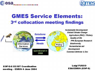
1
GMES Service Elements3rd collocation meeting
findings
Sustainable Development Global Climate
Change Agriculture (PAC) / Fishery
Quality of life FP6 European
Research Biodiversity
Humanitarian aid Development Common
Defense Sec
Solutions
Needs
Information Services
Policy
operational in 2008
Luigi FUSCO ESA/ESRIN (EOP-S)
EOP/G-S EC/IST Coordination meeting ESRIN 4
June 2004
2
GMES Concept
- GMES Global Monitoring for Environment and
Security - GMES is part of the EC-ESA European White Paper
on Space - This initiative responds to the emerging needs to
protect and monitor the environment at global,
regional and local scale. - Key actions are
- Provision of services
- Access Space observing systems and additional
in-situ observations systems - Data integration and information management
- Research Technology Development
- ESA prime focus is on
- The Space elements
- Development of Operational Services (GMES Service
Element)
3
GMES Concept
- GMES is the European contribution to the
International effort in preparing GEO (Global
Earth Observing System) to - Sustainable development
- Environmental treaty monitoring and international
conventions - Enhancing the security of citizens
- Preserving peace through transparency of
information - GMES is in line with the ESA Living Planet
Programme - Maintain Europe at the leading edge of Earth
Sciences - Formulation, implementation and monitoring of
public policies and in the provision of public
services - Forster the development of commercial services
using Earth Observation
4
Link with ESA EO programmes
EO exploitation (earth.esa.int) from Science to
Applications
Science
Research Path
Industry Path
User Path
Applications Demonstration
New Techniques
New Users
New Providers
Global Monitoring for Environment Security (GSE)
Market
Future EO missions
5
GMES plan
Autonomous Operational European capacity for
GMES
GMES Action plan endorsed by EC ESA
council (Nov 01)
ESA council Decision on implementation plan
Deployment of GMES space component (Earth Watch
Sentinels)
Baveno Manifesto (Oct 98)
GMES Forums
GMES Report
00
01
02
03
04
05
06
07
08
09
10
11
12
Implementation Period (stage 2)
Initial Period
Sustainability
GMES requires a space component insuring EO data
continuity
3nd GSE colocation
Total Budget 83M, 5yrs Initial Phase 10
projects 1.5M 20months
GSE Consolidation
GSE Full operationalisation
servicereviews
programmereview
6
GSE objectives
Services
End-users
Information
Geo Data
EO Met RD satellite data, remote
sensing, in-situ networks
Operational Earh System Monitoring Forecasting
GIS, Processing Data Fusion, Forecast Model
Citizens EU Policy Regulation body Env agency
Value chain
- GSE aims to make the end-to-end EO value chain
more effective by - Delivering information (not data) to end-users
(e.g. tactical / strategic) - Organising the supply (e.g. developing the
necessary infrastructure) - Federating the demand (e.g. user-pull, not
technology pushed) - Establishing a sustained dialogue with end-users
(e.g. policy body) - GSE aims to close the loop between operational
results and - definition of future systems such as Earth Watch
missions.
7
GSE methodology
- Key questions of consolidation
- What information is needed?
- What services can be provided?
- What are the benefits for Europes Citizens?
- Do the benefits justify the costs?
- Specific GSE mechanisms
- Precursor services
- Service Level Agreement
- Associated projects (links with
RD initiatives) - Open service partnership
- Strategy group / plan
Iterative Service cycle
User Consultation
Service Adjustment
Product Design
Promotion
Feedback Analysis (utility Report)
SLA
Delivery
Testing by users (validation report)
Training
- Geographic scope from global to regional to
local - Time scale present10y
8
3rd GSE Collocation meeting scope
- Critical review of each service in terms of
public benefits, user acceptance, scenarios for
implementation, milestones for sustainability - Coordination options between existing consortia
and identification of needs for additional
activities - Indications and requirements for future EO
operational capacity in Europe - Infrastructure requirements for in-situ data
gathering and data access, modelling and data
assimilation, data processing and fusion, service
delivery and user exploitation - Actions to be completed relating to service
validation and standardisation including
compliance with user standards
9
3rd GSE Collocation focus groups organisation
- Critical review of existing (48) GSE services by
partner organisations - GSE validation and standards
- User communities, federation
- GSE Supply side synergy and overlaps
- Service benefits impacts and costs
- Infrastructure requirements from different
service portfolios - availability of data sets and access
- Key infrastructure and issues
- Service partnership and agreements
- Service sustainability
10
3rd GSE Collocation space segment priorities
- Issue Continuity of key data sources is not
presently guaranteed and this impacts on the
credibility and acceptance of the service
portfolio - Findings
- Key sensors have been identified their
continuity must be assured - Marine priorities
- C band SAR - wideswathapol
- MODIS/MERIS type and ocean colour
- Land priorities
- High resolution optical (LandSAT-7 type)
- C band INSAR
- Atmosphere priority Post-ENVISAT combination of
atmospheric composition sensors
11
3rd GSE Collocation selected key messages
- Priority Services identified for progressive
implementation - During next stage significant effort needs
devoted to - service validation,
- standardisation and certification
- Users key service models are
- User generates information in-house using
licenced capability - User procures services from external provider
- Partnerships must be open and inclusive
- SLA is a key mechanism to facilitate move from
ESA funded activities to sustainable service
provision - Infrastructure requirements not detailed or
finalised. Follow-on funding options must be
better defined early in next stage of GSE
12
3rd GSE Collocation service user
infrastructure
- Users and their infrastructures are distributed
broadly with diverse service needs - Distributed service infrastructures must be
implemented rather than major centralized
developments - GSE stage 2 activities need to draw on
infrastructures developed by other organizations,
e.g. EC and EEA. - Service expansion requires some investment.
- Product improvement
- New and enhanced models, with increased
assimilation of EO and in situ data (e.g.
forecasting) - Create synergies between European service
providers - Commonly accessible data-pools (e.g. elevation
models) - Basic, common value-adding processing
- Communications networks (distributed networks,
centralization not foreseen) - Backup and redundancy
- Enhance productivity by automation of service
supply chain - Online archive facilities, catalogues, etc.
- Automatic feature detection algorithms (e.g. oil
spills) - Broker systems, improving user interface to
services
13
GMES challenges
Building blocks for Earth Information Monitoring
Forecasting services
- Exciting scientific research
- Validation / Certification
- Better EO algorithms Exploitation of new
information (Polarisation / Multi-angle) - Use state-of-the-art Earth System models
(biological, chemical component) - Need Error statistics for assimilation
Certification - Transfer of RD to operations
Models
Assimilation
In-situ
EO
BUT need for EO Data continuity!! Sentinel 1
C-band SAR Sentinel 2 MR WS superspectral
optical Sentinel 3 Ocean Altimeter
Colour Sentinel 4 Atmospheric GEO Sentinel 5
Atmospheric LEO
14
Coordination mechanisms
- Exchange Information
- Align Schedules
- Joint Meetings or reviews
- Access Models (Hind/now/forecast)
- Transfer Algos Software (IPR)
- Validate Products
- Test New Services
- Agree Common Standards
- Common Approach to users
Project Level
IP Integrated Project (RD demo)
G S E
Definition of common terminology Services
Portofolio
Operational Service Provision
Research methods and demonstration
15
GSE portfolio
- Forest Monitoring GAF (De)
- SAGE Infoterra (De)
- GMFS Vito (Be)
- URBAN Indra (Es)
- TERRAFIRMA NPA (Uk)
- RISK-EOS Astrium (Fr)
- RESPOND Infoterra (Uk)
- ROSES Alcatel (Fr)
- CoastWatch EADS (Fr)
- Northern View C-Core (Ca)
- ICEMON Met No (No)
- PROMOTE KNMI (Nl)
USER in the DRIVING SEAT
Right info, at the right time, at the right place
Delivered to International / Regional / Local
users such as EU institutions, Environment
Agencies, Regulatory bodies, Statistical
agencies, natural resource, mapping agencies
16
Proposal for progressive implementation
- European scale services
- Marine and coastal environment information
service - Land information service
- Polar environment information service
- Regional scale services
- Forest Monitoring
- Fire and Flood Risk Management
- Geophysical Hazard Monitoring
- Global Monitoring for Food Security
- Continuation of consolidation activities
- RESPOND (humanitarian aid)
- PROMOTE (atmosphere)
- Progressive implmentation to be continued but
full implications for next phase of GSE not fully
defined,e.g. - 15000 ScanSAR scenes per year in near real time
for European oil spill surveillance - Complete analysis of landslide risk on monthly
basis
17
Marine and CoastalEnvironment Surveillance
Monitoring
18
Marine Coastal services big picture
Intl conventions secretariats OSPAR, Helsinki,
MAP
EMSA
EEA
EU DGs
Health safety agencies
Coast guards
environment agencies
Food/ fisheries agencies
Portauthorities
Coastal Environment
Systematic monitoring and detection for ALERT
Decision support information
Reference DB administration
Coastal Management information
In-situ datacollectionnetworks
VTMSoperators
NRTradarimagery
NRToptical imagery
Ocean state forecast
Meteo forecast
Airborne surveillance operators
GSoperators
Satelliteoperators
Ocean modeloperators
Meteo models operators
19
Marine Coastal services
- The service portfolio is articulated around three
levels of information - Oil spill detection, drift forecast and impact
assessment. - Water quality
- Monitoring and Assessment
- Algae Bloom alert service
- Coastal Habitat mapping
- Coastal Vulnerability and risk assessment
- Coastal indicators
- Geophysical information mapping
- Near-shore wave and wind
to Recommendations
20
Conclusions
- Formal definition of infrastructure requirements
not yet finalised - First priority services for progressive
implementation identified these have
significant implications wrt infrastructure - NRT availability
- European wide coverage
- Large number of local customised models
presently with little or no assimilation of EO
based information - Widely distributed user base to be satisfied by
service infrastructure
Recommended
CrystalGraphics Presentations


