
Geostationary Sounders - PowerPoint PPT Presentation
Title:
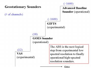
Geostationary Sounders
Description:
(~1600) Geostationary Sounders (# of channels) Advanced Baseline Sounder (operational) (~1600) GIFTS (experimental) (18) GOES Sounder (operational) The ABS is the ... – PowerPoint PPT presentation
Number of Views:144
Avg rating:3.0/5.0
Title: Geostationary Sounders
1
(1600)
Geostationary Sounders ( of channels)
Advanced Baseline Sounder (operational)
(1600)
GIFTS (experimental)
(18)
GOES Sounder (operational)
The ABS is the next logical step from
experimental low spectral resolution to finally
operational high-spectral resolution sounders.
(12)
VAS (experimental)
time
2
GOES Sounder Spectral Coverage Current
instrument has 18 infrared bands.
3
ABS Prime (ABS) -- consider using the shortwave
side of the water vapor band.
4
Low vs High Spectral Resolution Retrieval
Simulations
Future GOES -- simulating the Advanced Baseline
Sounder (ABS) performance
Temperature
Moisture
Geo-I gets lt1 K rms for 1 km T(p) and lt10 rms
for 2 km RH(p)
5
ABS/CrIS vs GOES retrieval for low level
temperature inversion
6
100
100
Advanced Sounder (3074)
GOES (18)
Pressure (hPa)
Pressure (hPa)
1000
1000
Moisture Weighting Functions
High spectral resolution advanced sounder will
have more and sharper weighting functions
compared to current GOES sounder. Retrievals will
have better vertical resolution.
UW/CIMSS
7
These water vapor weighting functions reflect the
radiance sensitivity of the specific channels to
a water vapor change at a specific level
(equivalent to dR/dlnq scaled by dlnp).
Moisture Weighting Functions
Pressure
Weighting Function Amplitude
Wavenumber (cm-1)
UW/CIMSS
The advanced sounder has more and sharper
weighting functions
8
Spatial Coverage
Areas within 62 degrees local zenith angle from
GOES-East and GOES-West sub-satellite points are
indicated. Threshold coverage rate calls for the
62 arc region, excluding half of over-lap, to be
scanned each hour. Current GOES -E and -W sounder
hourly coverage is also shown.
UW-Madison/CIMSS
9
Geo-Interferometer Nears Raob-like Depiction of
Atmosphere while Providing an Order of Magnitude
Increase in Temporal Resolution
Information Content for Moist Atmospheres
interferometer
current
Number of channels
RAOB (USA) - over land - 1 hour ascent -
300 km separation - 12 Z and 00Z only
Geo Interferometer (USA) - land and coastal
waters - nearly instantaneous obs - 10-50 km
separation - hourly repeat
A doubling of the critical low-level moisture
information (from the current sounder)
10
Cloud-Top Information
Future GOES -- simulating the Advanced Baseline
Sounder (ABS) performance
11
Detection of Temperature Inversions Possible with
Interferometer
GOES
GOES
Wavenumber (cm-1)
The detection of inversions is critical for
severe weather forecasting. Combined with
improved low-level moisture depiction, critical
ingredients for night-time severe storm
development over the Plains can be monitored.
Knowing if there is an inversion can also help
improve the profiles estimates.
12
Potential ABI
Plus a 0.9 um band
13
MODIS (1 km)
ABI (2 km)
UW-Madison/CIMSS
Severe convection IR windows 25 February 2001
GOES-8 (4 km)
The simulated ABI clearly captures the
over-shooting (cold) cloud tops, while the
current GOES Imager does not. Images shown in
GOES projection.
14
Visible
15
(No Transcript)
16
ABI spatial coverage rate versus the current
GOES Imager
The ABI may take full disk images every 15 min.
CONUS images every 5 min.
17
Visible
18
linden_haze_0.439_0.498
Smoke
Recommended
CrystalGraphics Presentations


