
The Four Major Regions of Texas - PowerPoint PPT Presentation
1 / 17
Title:
The Four Major Regions of Texas
Description:
The Four Major Regions of Texas Great Plains Region Central ... (irrigation from wells) Ranching - cattle, sheep, goat Oil and gas in the Permian Basin Natural ... – PowerPoint PPT presentation
Number of Views:263
Avg rating:3.0/5.0
Title: The Four Major Regions of Texas
1
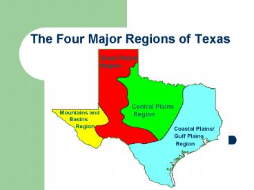
The Four Major Regions of Texas
Great Plains Region
Central Plains Region
Mountains and Basins Region
- Coastal Plains/
- Gulf Plains
- Region
2
Coastal Plains/Gulf Plains Region
- Location
- Covers 1/3 of the land of Texas
- Northeast border is the Sabine River
- Southeast border is the Gulf of Mexico
- West border is the Balcones Escarpment
- Climate
- Hot and damp, humid
- Tornadoes, hurricanes
- 30-55 inches of rain per year
3
Coastal Plains/Gulf Plains Region
- Natural Resources
- Plants - pine trees, hardwood trees (elm, oak,
cottonwood, pecan) - Various Animals
- Minerals
- Bodies of water
- Economic Resources
- Farming
- Fishing
- Ranching
- Tree farms - lumber businesses
- Oil and gas (1901)
- Factories
- Ports
4
Coastal Plains/Gulf Plains Region
- Geographic Subdivisions
- Gulf Coast Plain
- South Texas Plain
- Piney Woods
- Post Oak Belt
- Blackland Prairie
5
Coastal Plains/Gulf Plains Region
- Pictures
6
Central Plains Region
- Location
- Part of the Great Central Plains of the US and
Canada - East border is the Coastal Plains
- South border is the Colorado River
- North border is the Red River
- West border is the Cap Rock Escarpment
- Climate
- Dry air
- Tornadoes
- 20-30 inches of rain per year
7
Central Plains Region
- Natural Resources
- Limestone
- Minerals
- Streams
- Fertile lands for crops
- Economic Resources
- Farming - fruits, vegetables, watermelons, oats
- Ranching - cattle, angora goats (mohair)
- Cedar trees - fenceposts
- Oil and gas
8
Central Plains Region
- Geographic Subdivisions
- Cross Timbers
- Grand Prairie
- Rolling Plains
9
Central Plains Region
- Pictures
10
Great Plains Region
- Location
- Part of the Great Plains of the US and Canada
- Most of the Panhandle and Edwards Plateau
- East South borders are escarpments
- Southwest border is the Mountains and Basins
Region
- Climate
- Dry air
- Hot summers
- Cold winters
- Dust storms
- 16-20 inches of rain per year
11
Great Plains Region
- Natural Resources
- Natural Resources
- Short grasses
- Mesquite, cedar, pecan, and oak trees in Edward
Plateau area - Deer
- Wild turkeys
- Economic Resources
- Farming - cotton, wheat (irrigation from wells)
- Ranching - cattle, sheep, goat
- Oil and gas in the Permian Basin
12
Great Plains Region
- Natural Resources
- Geographic Subdivisions
- High Plains
- Edwards Plateau
- Llano Basin
13
Great Plains Region
- Natural Resources
- Pictures
14
Mountains and Basins Region
- Location
- Far west Texas
- East border near Pecos River
- South border is the Rio Grande
- North border is New Mexico
- Climate
- Driest part of state
- 8 inches of rain per year, 20 in mountains
- Hot days, cool nights
15
Mountains and Basins Region
- Natural Resources
- Plants - short grasses, shrubs,
- desert plants in plateaus and basins
- pine forests in mountains
- Economic Resources
- Ranching - cattle, sheep, goat
- Farming - cotton, fruits, vegetables, cantaloupes
- (irrigation in El Paso and Pecos River
Valley) - Oil and gas - part of Permian Basin
16
Mountains and Basins Region
- Geographic Features
- 150 mountains in the mountain ranges
- Plateaus and basins
- Deserts
- Pecos and Rio Grande Rivers
- Big Bend National Park
17
Mountains and Basins Region
- Pictures
Recommended
CrystalGraphics Presentations


