
Chris Raymond - PowerPoint PPT Presentation
1 / 18
Title:
Chris Raymond
Description:
Mapping spatial attributes in survey research for natural resource management: ... Journal of Sustainable ... GIS Information Map Layer **LANDSCAPE VALUES ... – PowerPoint PPT presentation
Number of Views:88
Avg rating:3.0/5.0
Title: Chris Raymond
1
Mapping landscape values for natural resources
management planning
- Chris Raymond
- Land and Biodiversity Services Division, DWLBC
2
Outline
- What are landscape values?
- Why map them?
- How do you map them?
- What do the results look like?
- What are the implications for NRM planning?
3
What are landscape values?
- Attachment or emotional bond that people develop
with place - Use value (places that provide tangible benefits)
- Economic Value
- Recreation Value
- Non-use value (places that represent ideas)
- Spiritual Value
- Future Value
4
Map Layer
GIS Information
LANDSCAPE VALUES
Government assets
Commercial activity
Wildfire threat
Salinity
Threatened species
Water quality
Soil type
Towns and suburbs
Planning Study Index Reference
5
Why map landscape values?
- Lack of systematic methods for identifying and
integrating community values into NRM - Values are linked to political acceptability of
land-use decisions - Integral to Goal 3 of the State NRM Plan (Peoples
and Communities) - 3.4.4 Seek and value the knowledge, skills and
expertise of local people, including Aboriginal
landholders, in planning and on-ground delivery - Identify place-specific priorities for NRM
investment.
6
How do you map landscape values?
- Sample
- Survey Instrument
- Map
- Landscape Values Typology
- Survey Mail Out (Dillman TDM)
- Data Entry
- Results Analysis
7
(No Transcript)
8
(No Transcript)
9
Title is typed in Blue
10
(No Transcript)
11
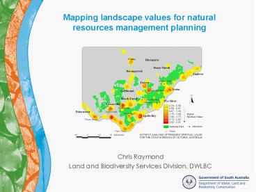
What do the results look like?Case Study 1
Otways Region of Victoria
12
Hotspot analysis of aesthetic value
13
Hotspot analysis of spiritual value
14
Hotspot analysis of tourism developmentpreference
s
15
West Central Alberta, Canada
16
(No Transcript)
17
Implications for NRM planning
- Systematic and representative process
- Transparent
- Identify areas of values conflict and special
management concern - Overlay with other land attributes for integrated
resource management - Recognises the role of non-use values in resource
decision making - Provides a baseline for monitoring and evaluation
18
References
- Brown, G. 2005. Mapping spatial attributes in
survey research for natural resource management
Methods and applications. Society and Natural
Resources 18(1)17-39. - Brown, G., and Raymond, C. (2007) The
relationship between place attachment and
landscape values Toward mapping place
attachment. Applied Geography 27(2)89-111. - Raymond, C., and Brown, G. (2006) A method for
assessing protected area allocations using a
typology of landscape values. Journal of
Environmental Planning and Management
49(6)797-812. - Raymond, C., and Brown, G. (2007). A spatial
method for assessing resident and visitor
attitudes toward tourism growth and development.
Journal of Sustainable Tourism. Anticipated
publication in Volume 15, issue 4 or 5..