
Maps and Scale Drawings - PowerPoint PPT Presentation
Title:
Maps and Scale Drawings
Description:
Maps and Scale Drawings ... of the drawing. scale length actual length 4 260 = 1 65 Divide each measure by the ... actual distance for a map distance of 6.2 cm ... – PowerPoint PPT presentation
Number of Views:145
Avg rating:3.0/5.0
Title: Maps and Scale Drawings
1
Maps and Scale Drawings
COURSE 2 LESSON 5-7
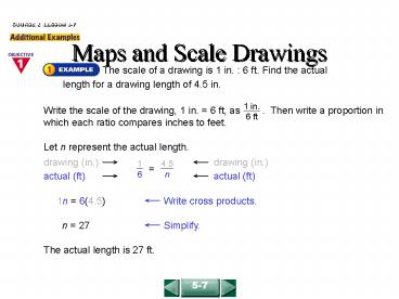
The scale of a drawing is 1 in. 6 ft. Find the
actual length for a drawing length of 4.5 in.
Let n represent the actual length.
The actual length is 27 ft.
5-7
2
Maps and Scale Drawings
COURSE 2 LESSON 5-7
On a map of North Carolina, the map distance
from Asheville to Raleigh would be about 4.4 cm.
Find the actual distance from Asheville to
Raleigh. The scale on the map is 1cm 75 km.
The actual distance from Asheville to Raleigh is
about 330 km.
5-7
3
Maps and Scale Drawings
COURSE 2 LESSON 5-7
The actual length of the wheelbase of a mountain
bike is 260 cm. The length of the wheelbase in a
scale drawing is 4 cm. Find the scale of the
drawing.
The scale is 1 cm 65 cm.
5-7
4
Maps and Scale Drawings
COURSE 2 LESSON 5-7
1. The scale of a map is 1 cm 25 km. Find the
actual distance for a map distance of 6.2
cm. 2. The actual length of a machine part is
40 in. The length of the machine part in a scale
drawing is 5 in. Find the scale of the drawing.
155 km
1 in. 8 in.
5-7
Recommended
CrystalGraphics Presentations


