
The South Atlantic Bight - PowerPoint PPT Presentation
1 / 11
Title:
The South Atlantic Bight
Description:
The South Atlantic Bight Cape Hatteras Cape Canaveral – PowerPoint PPT presentation
Number of Views:24
Avg rating:3.0/5.0
Title: The South Atlantic Bight
1
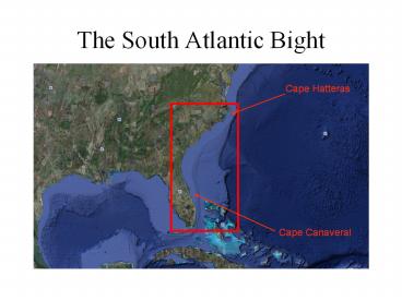
The South Atlantic Bight
Cape Hatteras
Cape Canaveral
2
Inner Shelf (0-20m)
Middle Shelf (20-40m)
Outer Shelf (40-70m)
Lee et al. (1991)
3
(Lee et al., 1991)
4
Upwelling on the SAB
- Upwelling on the SAB is primarily in response to
eddies and meanders in the Gulf Stream Front. - The distance waters penetrate across the shelf
depends on wind velocity, local topography and
the density of resident shelf waters (Pietrafesa
et al., 1985 Lee et al., 1985 Atkinson et al.,
1985). - There are two types of upwelling on the SAB
- Type 1 During all seasons eddies and meanders
associated with the Gulf Stream front cause
upwelling at the shelf break with periods of 2-14
days. - Type 2 When the shelf is thermally stratified in
May-October, upwelled waters penetrate across the
shelf as subsurface intrusions of cold,
nutrient-rich water.
(Yoder, 1985)
5
Seasonal surface currents from mean sum
geostrophic components and Ekman. Red vectors
indicate the general direction of mean winds for
each season. Black vectors indicate mean surface
current speed and direction (5-10 cm/s)
(Signorini McClain, 2006)
6
Ekman equations Deep water
V
Ekman equations Shallow water
V
7
SAB summary
- 3 distinct bathymetrically separated regions
- Inner, middle and outer shelves.
- Gulf stream is the primary method of onshore
nutrient transport/upwelling. - Coastal currents are in the direction of mean
winds, which all vary seasonally.
8
- Questions?
- References
- Janowitz, G.S., and L.J. Pietrafesa (1982), The
effects of alongshore variation in bottom
topography on a boundary currentTopographically
induced upwelling, Cont. Shelf Res., 1, 123-141. - Lee, T. N., J. A. Yoder, and L. P. Atkinson
(1991), Gulf Stream Frontal Eddy Influence on
Productivity of the Southeast U.S. Continental
Shelf, J. Geophys. Res., 96(C12), 22,19122,205. - Signorinni, S. R., and C. McClain (2006), Remote
versus local forcing on chlorophyll variability
in the South Atlantic Bight, NASA Tech. Mem.,
2006-214145. - Yoder, J.A. (1985), Environmental Control of
Phytoplankton Production on the Southeastern U.S.
Continental Shelf, in Oceanography of the
Southeastern U.S. Continental Shelf, Coastal and
Estuarine Sciences 2, edited by L.P. Atkinson et
al., pp.93-103, AGU, Washington, D.C.
9
Seasonal climatology maps of AVHRR SST. The
inner shelf has the coldest surface temperatures
in winter, which are around 10 oC. Rapid
winter cooling is due to convective overturn and
tidal and wind mixing. Warmest surface
temperatures in summer reach 28-30oC on the shelf.
(Signorini McClain, 2006)
10
Seasonal maps of SeaWiFS surface
Chl-a. Chlorophyll is generally higher on the
inner shelf due to available terrestrial
nutrients. Maximum concentrations occur in late
winter early spring due to nutrient availability
from increased river discharge. Minimum
concentrations are found in summer due to
nutrient depletion and increased stratification.
(Signorini McClain, 2006)
11
(No Transcript)
Recommended
CrystalGraphics Presentations


