
Overview of sh_gamit / sh_glred processing - PowerPoint PPT Presentation
Title:
Overview of sh_gamit / sh_glred processing
Description:
Overview of sh_gamit / sh_glred processing Create /tables, /rinex, /gsoln directories, run sh_setup - in /tables, copy/edit control files - in /rinex, copy/link RINEX ... – PowerPoint PPT presentation
Number of Views:24
Avg rating:3.0/5.0
Title: Overview of sh_gamit / sh_glred processing
1
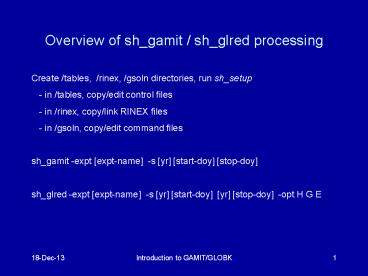
Overview of sh_gamit / sh_glred processing
- Create /tables, /rinex, /gsoln directories, run
sh_setup - - in /tables, copy/edit control files
- - in /rinex, copy/link RINEX files
- - in /gsoln, copy/edit command files
- sh_gamit -expt expt-name -s yr start-doy
stop-doy - sh_glred -expt expt-name -s yr start-doy
yr stop-doy -opt H G E
2
Directory Structure
- Top level global tables and survey directories
- Within each survey directory
- /tables /rinex /igs /gfiles /brdc /gsoln
/glbf - /day1 /day2
- Tables are linked from day directories to
experiment /tables and then to gg/tables
- GAMIT processing occurs in the day directories
- GLOBK processing occurs in /gsoln
3
sh_gamit internal operation
- A day directory is created
- sh_get_rinex gets RINEX files requested by
sites.defaults from an external archive - sh_link_rinex links from /rinex to the day
directory all files with data for the day - ( rx_doy_minus and rx_doy_plus may be needed
for multi-day RINEX files) - sh_get_nav downloads into /brdc a navigation file
for the day - sh_get_orbits downloads into /igs an sp3 file and
creates a g-file - sh_makexp and makex create d-, j-, and x-files
for the GAMIT batch run - fixdrv prepares the batch control files
- arc integrates GPS satellite orbits
- model calculates theoretical (modeled) phase and
partial derivatives of phase with respect to
parameters - autcln repairs cycle slips, removes phase
outliers, and resolves the wide-lane ambiguities - solve estimates parameters via least squares
4
Steps in the standard GAMIT batch sequence
- arc model, autcln, solve for initial solution
- 5-minute sampling, no ambiguity resolution
(GCR only) - update lfile for coordinates adjusted gt 30
cm - --gt autcln.prefit.sum, qexptp.ddd , oexptp.ddd
- model, autcln, solve for final solution
- 2-minute sampling, ambiguity resolution
- --gt autcln.post.sum, qexpta.ddd , oexpta.ddd
( GCR, GCX, GLR, GLX ) - Final solution repeated if nrms reduced by gt 30
from initial solution, to assure good editing and
linear adjustment of parameters (original
final-solution files overwritten)
5
Files you need to worry about
- RINEX files local plus list in sites.defaults
- Control files
- process.defaults minor edits for each
survey - sites.defaults sites to include/omit
source of metadata - sestbl. unchanged for most processing
- sittbl. sites constrained for ambiguity
resolution - globk_comb.cmd use_site, apr_neu, apr_svs,
apr_wob, apr_ut1, sig_neu, mar_neu - glorg_comb.cmd apr_file, pos_org, stab_site
- A priori coordinates ( apr-file, l-file )
- Meta-data (station.info)
- Differential code biases (dcb.dat) download
current values 1/month - Satellite characteristics (svnav.dat) download
current w/ each new launch
6
Files provided or created automatically
- Satellite orbits
- IGS sp3-files (tabular) and/or g-files (ICs
for GAMIT) - ARC integrates to get t-files (tabular)
- Earth Orientation Parameters ( ut1., wob.) -
downloaded if needed for current day - Leap-second file -- linked to gg/tables (update
yearly) - Satellite clock (j-) files from RINEX
navigation (brdc) file - Rcvr/ant characteristics (rcvant.dat, hi.dat)
linked to gg/tables - Differential code biases (dcb.dat)update
monthly - Antenna phase center models (antmod.dat) linked
to gg/tables - Luni-solar ephemerides and nutation (soltab.,
luntab., nutabl.) linked to gg/tables (need to
update yearly) - Ocean tide grid (optional) linked to gg/tables
- Atmospheric loading grid (optional) need to
update yearly - Mapping function grid (optional) need to update
yearly
7
Options for metadata (station.info)
- Pre-prepared station.info
- Use sh_upd_stnfo l sd to reduce the (global)
station.info file to only those you need - Use sh_upd_stnfo f ../rinex/ to add entries
for local files from the RINEX headers (may then
need editing to fix header errors) or - Use make_stnfo to create a survey-mode file
interactively from log sheets, and then run
sh_upd_stnfo merge file to merge this file
with the reduced global file - Use sh_upd_stnfo to merge the local and
reduced-global station.info files - Must set xstinfo in sites.defaults
- RINEX headers (sh_gamit default may change soon)
- Update station.info unless an entry already
exists for the day being processed or
stinf_unique is set to -u in process.defaults and
entry has not changed - For manual or automatic reading of RINEX headers
by sh_upd_stnfo, non-standard receiver, antenna,
or firmware names can be recognized by adding
them to guess_rcvant.dat (ideally your rinex
files have the IGS official receiver and antenna
names). It is critical that this information be
correct.
8
A priori coordinates (sh_gamit)
- Create l-file in day directory by merging
existing lfile. and apr_file from ../tables
(apr_file has priority) - If site not found in l-file
- Use RINEX header coordinates (use_rxcY)
- or
- Use pseudorange data in RINEX file to estimate
point position or differential position relative
to a site in sites.defaults (use_rxcN, default) - During the sh_gamit run, the coordinates are
updated (and copied to ../tables/lfile.) if they
are in error by gt 30 cm
9
Ambiquity resolution
- (L2-L1) resolved by autcln and passed to solve
in the n-file ( LC_AUTCLN ) - weak dependence on geometry
- need current dcb.dat file
- use LC_HELP for codeless data ( before 1995)
or if problems (default max distance is 500 km) - Narrow-lane (L1) resolved by solve
- strong dependence on phase noise and models
- 5-10 cm constraints on a priori coordinates
usually sufficient
10
sh_gamit_ddd.summary (email)
- Contents (Yellow is output)
- Input options -d 2002 30 31 32 33 -expt ncar
-pres ELEV -yrext -netext a - Processing 2002 031 GPS week 1151 4 Raw 2
- /data51/tah/SENH02/glob02/suomi/2002_031a
- Disk Usage 12678.4 Free 76447.4 Mbyte. Used
15 - Summary Statistics ( from autcln )
- Number of stations used 4 Total xfiles 4
- Postfit RMS rms, to and by satellite
- RMS IT Site All 01 02 03 04 05 06 07
08 09 - RMS 20 ALL 4.8 4 5 6 5 5 4 5
4 5 - Best and Worst two sites
- RMS 20 TMGO 3.2 3 3 4 4 4 3 3
3 4 - RMS 20 SA09 4.6 4 4 5 4 5 4 4
4 5 - RMS 20 PLTC 5.4 4 5 5 6 5 4 5
5 6 - RMS 20 SA13 5.5 5 5 6 5 5 5 5
5 6
11
sh_gamit_ddd.summary (email)
- Solution statistics from solve
- Double difference statistics
- Prefit nrms 0.31280E03 Postfit nrms
0.21324E00 Constrained free - Prefit nrms 0.31185E03 Postfit nrms
0.21818E00 Constrained fixed - Prefit nrms 0.31272E03 Postfit nrms
0.20470E00 Loose free - Prefit nrms 0.31185E03 Postfit nrms
0.20756E00 Loose fixed - Number of double differences 12447
- Numbers of WL and NL biases 120 Perscent fixed
95 WL 85 NL - Any large adjustments to positions (gt0.3 m)
- Things to note
- Number of stations matches expectation
- Site postfit RMS values 3-10 mm
- No stations with RMS 0 ( implies no data
retained by autcln ) - Postfit nrms from solve 0.2 for constrained and
loose solutions - Most ambiguities resolved (70-85 for noisy
days, gt 90 for best)
12
Phase Residual Plots
- Set with -pres elev in sh_gamit command line
(requires GMT) - Postscript files in day directory, by default
converted to gif in /gifs directory and then
erased - Use to assess multipath, water vapor, and antenna
phase center model
Sky plot
Phase vs elevation angle
13
High residuals in the same place at different
times suggest mulitpath High residuals
appearing in a given place only at one time
suggest water vapor
14
Phase vs elevation angle
- Normal pattern bands are high-frequency
multipath red is smoothing of individual values,
showing no strong systematics - Bad pattern systematic signature of smoothed
values indicates a poor model of the antenna
phase pattern (perhaps a misidentified antenna in
station.info) - Green lines show the elevation-dependent noise
model shown at top and used to reweight the data
in solve
15
What can go wrong?
- Site missing (not listed)
- - no RINEX data within session span check
RINEX file and/or makex.expt.infor - - too few data, x-file too small and not used
check RINEX file size, change minxf in
process.defaults - Site in solution but no data or adjustment
- - a priori coordinates gt 10 m off check
range rms in autcln.prefit.sum, run sh_rx2apr
differentially for several RINEX files - - bad receiver examine RINEX files or
initial c-files with cview - Q-file nrms gt 0.2
- - solution over-constrained check GCX vs GLX
nrms, rerun with only one site constrained
16
Problems with a priori coordinates
- Need to be good to lt 10 m to get through autcln
- Safest source is a previous solution or a
pseudorange solution using svpos/svdiff
(sh_rx2apr) - Range rms and bias flags added from autcln
summary file are a useful check - Convergence is 1100 to 11000 (1 m error in apr
can lead to 1-10 mm error in adjustment)hence
automatic update of L-file for GAMIT 2nd solution - Watch for repeated updates in email summary as a
sign of bad data
17
Constraining the GAMIT solution
- Minimal (single-station) constraint is all thats
needed for ambiguity resolution, but sittbl can
list several to assure one - Orbits can be fixed or tightly constrained (.005
ppm) for IGS orbits since at least 1996 - Look for good (0.2) loose (GLR/GLX) nrms but
elevated constrained nrms (GCR/GCX) as indication
of an over-constrained solution
18
More Subtle Problems
- Site with high rms in autcln.post.sum
- - high multipathing or water vapor check sky
plots of phase - - bad receiver examine RINEX files or
initial c-files with cview - Phase vs elevation angle plot large and
systematic - - misidentified antenna (wrong PCV model)
- - coupling between antenna and mount
(discussed during height section) - GAMIT results within normal range but time series
shows outlier - - survey-mode antenna not leveled and centered
over mark - - change in multipath (water, objects) or
water vapor - - snow on antenna
- - incorrect ambiguity resolution (east
component except for high latitudes)
19
Understanding outliers Autcln rms Day 201 9.6
mm Day 202 6.0 mm
20
ALBH 2003 Day 201
ALBH 2003 Day 202
21
GPS adjustments to atmospheric zenith delay for
29 June, 2003 southern Vancouver Island (ALBH)
and northern coastal California (ALEN). Estimates
at 2-hr intervals (produced by sh_gamit_atmos
from the o-file)
Recommended
CrystalGraphics Presentations


