
Global-Scale Links with Local-Scale - PowerPoint PPT Presentation
1 / 21
Title:
Global-Scale Links with Local-Scale
Description:
Global ocean and climate dynamics strongly influence processes at ... correction procedure; resolution should be better than 100 m for benthic habitat charac ... – PowerPoint PPT presentation
Number of Views:34
Avg rating:3.0/5.0
Title: Global-Scale Links with Local-Scale
1
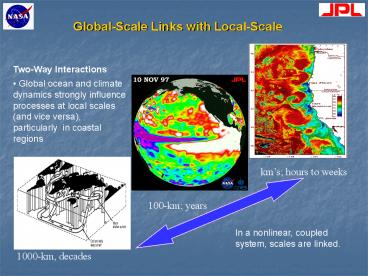
Global-Scale Links with Local-Scale
- Two-Way Interactions
- Global ocean and climate dynamics strongly
influence processes at local scales (and vice
versa), particularly in coastal regions
kms hours to weeks
100-km years
In a nonlinear, coupled system, scales are linked.
1000-km, decades
2
Coastal Zones Dynamic, Interfacial Regions
Coastal zones are dynamic regions, at the
interface of land, sea and air. They also are
typically heavily populated and often urbanized.
There is frequent exchange of energy and matter
across boundaries, with humans impacting the
ocean and vice versa.
3
Observational Strategies Geostationary
Hyperspectral Imaging Radiometer Multi-Spectral
High Spatial Resolution Imager Sub-Orbital
Survey and Events UAV Suite Synthetic Aperture
Radar (incl. along-track interferometry)
4
Geostationary Hyperspectral Imaging
Radiometer High level question(s)
Biogeochemistry, Ecosystems, Hazards Key issues
Quantifying the carbon pathways and flux in the
coastal zone is one of the most challenging
scientific problems of the global carbon
budget, complicated by significant complexity in
the following realms Temporal dynamic
ephemeral events, cloud cover, tidal
aliasing Optical diverse water/atm constituents
- PP, SPM, CDOM aerosols Spatial variability
often order of 100s of m to a few km in
horizontal extent
5
Geostationary Hyperspectral Imaging
Radiometer High level question(s)
Biogeochemistry, Ecosystems, Hazards Key issues
Quantifying the carbon pathways and flux in the
coastal zone is one of the most challenging
scientific problems of the global carbon
budget, complicated by significant complexity in
the following realms Temporal dynamic
ephemeral events, cloud cover, tidal
aliasing Optical diverse water/atm constituents
- PP, SPM, CDOM aerosols Spatial variability
often order of 100s of m to a few km in
horizontal extent Characteristics Spectral
coverage from 340nm to 1000nm with 1300nm goal
on a single 2-D detector array Spectral sample
2 to 4nm Complete coastal CONUS coverage 4
times per day minimum Regional repeats gt 10
times per 6 hours Event coverage at 15 minute
intervals Spatial foot print 50 to 200 m NADIR
with gt1000 element swath SNR 1500-500 minimum -
SNR with image summing gt 3000.
6
Geostationary Hyperspectral Imaging
Radiometer High level question(s)
Biogeochemistry, Ecosystems, Hazards Key issues
Quantifying the carbon pathways and flux in the
coastal zone is one of the most challenging
scientific problems of the global carbon
budget, complicated by significant complexity in
the following realms Temporal dynamic
ephemeral events, cloud cover, tidal
aliasing Optical diverse water/atm constituents
- PP, SPM, CDOM aerosols Spatial variability
often order of 100s of m to a few km in
horizontal extent Characteristics Spectral
coverage from 340nm to 1000nm with 1300nm goal
on a single 2-D detector array Spectral sample
2 to 4nm Complete coastal CONUS coverage 4
times per day minimum Regional repeats gt 10
times per 6 hours Event coverage at 15 minute
intervals Spatial foot print 50 to 200 m NADIR
with gt1000 element swath SNR 1500-500 minimum -
SNR with image summing gt 3000. Implementation
Short-term pursue dedicated ESSP-class mission
or potential instrument of opportunity - to
commence development in the next 5 years.
7
Geostationary Hyperspectral Imaging
Radiometer High level question(s)
Biogeochemistry, Ecosystems, Hazards Key issues
Quantifying the carbon pathways and flux in the
coastal zone is one of the most challenging
scientific problems of the global carbon
budget, complicated by significant complexity in
the following realms Temporal dynamic
ephemeral events, cloud cover, tidal
aliasing Optical diverse water/atm constituents
- PP, SPM, CDOM aerosols Spatial variability
often order of 100s of m to a few km in
horizontal extent Characteristics Spectral
coverage from 340nm to 1000nm with 1300nm goal
on a single 2-D detector array Spectral sample
2 to 4nm Complete coastal CONUS coverage 4
times per day minimum Regional repeats gt 10
times per 6 hours Event coverage at 15 minute
intervals Spatial foot print 50 to 200 m NADIR
with gt1000 element swath SNR 1500-500 minimum -
SNR with image summing gt 3000. Implementation
Short-term pursue dedicated ESSP-class mission
or potential instrument of opportunity - to
commence development in the next 5 years. Longer
term next generation to provide higher spatial
res and/or other obs. (e.g., SST) constellations.
8
Multi-Spectral High Spatial Resolution
Imager High level question(s) Habitats,
Hazards, Ecosystems Key issues Nearshore
ecosystems/habitats are at the boundary between
land and ocean and are continuously subject to
both natural and anthropogenic sources of change.
Remote sensing is challenging, esp. due to
spatial scales ranging ms to kms in extent.
9
Multi-Spectral High Spatial Resolution
Imager High level question(s) Habitats,
Hazards, Ecosystems Key issues Nearshore
ecosystems/habitats are at the boundary between
land and ocean and are continuously subject to
both natural and anthropogenic sources of change.
Remote sensing is challenging, esp. due to
spatial scales ranging ms to kms in
extent. Characteristics minimum of 20 bands
spanning violet through NIR with a few bands
into the SWIR Narrower bands are needed to
better quantify solar stimulated chlorophyll
fluorescence Bands must also be provided to
implement a research quality atmospheric
correction procedure resolution should be
better than 100 m for benthic habitat
charac- terization at the community level and 10
to 20 m/pixel resolution would be optimal
Sample around coastlines on a sun-sync polar
orbit minimum of 100 km swath.
10
Multi-Spectral High Spatial Resolution
Imager High level question(s) Habitats,
Hazards, Ecosystems Key issues Nearshore
ecosystems/habitats are at the boundary between
land and ocean and are continuously subject to
both natural and anthropogenic sources of change.
Remote sensing is challenging, esp. due to
spatial scales ranging ms to kms in
extent. Characteristics minimum of 20 bands
spanning violet through NIR with a few bands
into the SWIR Narrower bands are needed to
better quantify solar stimulated chlorophyll
fluorescence Bands must also be provided to
implement a research quality atmospheric
correction procedure resolution should be
better than 100 m for benthic habitat
charac- terization at the community level and 10
to 20 m/pixel resolution would be optimal
Sample around coastlines on a sun-sync polar
orbit minimum of 100 km swath.
Implementation target Short-term pursue
partnership w/Landsat Data Continuity Mission
(e.g., add 3-6 high sensitivity bands, 10-20 nm
width)
11
Multi-Spectral High Spatial Resolution
Imager High level question(s) Habitats,
Hazards, Ecosystems Key issues Nearshore
ecosystems/habitats are at the boundary between
land and ocean and are continuously subject to
both natural and anthropogenic sources of change.
Remote sensing is challenging, esp. due to
spatial scales ranging ms to kms in
extent. Characteristics minimum of 20 bands
spanning violet through NIR with a few bands
into the SWIR Narrower bands are needed to
better quantify solar stimulated chlorophyll
fluorescence Bands must also be provided to
implement a research quality atmospheric
correction procedure resolution should be
better than 100 m for benthic habitat
charac- terization at the community level and 10
to 20 m/pixel resolution would be optimal
Sample around coastlines on a sun-sync polar
orbit minimum of 100 km swath.
Implementation target Short-term pursue
partnership w/Landsat Data Continuity Mission
(e.g., add 3-6 high sensitivity bands, 10-20 nm
width) Near-term (5-10 years out) pursue
advanced multi-spectral, high-res global mission
as single instrument ESSP class mission or one
with additional aerosol measurement capabilities.
12
Multi-Spectral High Spatial Resolution
Imager High level question(s) Habitats,
Hazards, Ecosystems Key issues Nearshore
ecosystems/habitats are at the boundary between
land and ocean and are continuously subject to
both natural and anthropogenic sources of change.
Remote sensing is challenging, esp. due to
spatial scales ranging ms to kms in
extent. Characteristics minimum of 20 bands
spanning violet through NIR with a few bands
into the SWIR Narrower bands are needed to
better quantify solar stimulated chlorophyll
fluorescence Bands must also be provided to
implement a research quality atmospheric
correction procedure resolution should be
better than 100 m for benthic habitat
charac- terization at the community level and 10
to 20 m/pixel resolution would be optimal
Sample around coastlines on a sun-sync polar
orbit minimum of 100 km swath.
Implementation target Short-term pursue
partnership w/Landsat Data Continuity Mission
(e.g., add 3-6 high sensitivity bands, 10-20 nm
width) Near-term (5-10 years out) pursue
advanced multi-spectral, high-res global mission
as single instrument ESSP class mission or one
with additional aerosol measurement capabilities.
Long term 2nd generation hyperspectral imager
flown together with an ocean-aerosol lidar
additional Aerosl sensor such as a polarimeter
included to provide additional off-nadir
estimates.
13
Sub-Orbital Survey and Events UAV Suite High
level question(s) Habitats, Hazards,
Ecosystems Key issues Imagery with spatial
resolution of meters or less is critical for
mapping and tracking fine-scale features along
coastal margins, including river plumes, flooded
land regions, and seafloor features. Hazardous
and episodic events require repeat sampling on
the order of hours and not days or weeks, and
require an imaging platform that can be used
under cloud cover. Diel processes require
high-freq repeat observations.
14
Sub-Orbital Survey and Events UAV Suite High
level question(s) Habitats, Hazards,
Ecosystems Key issues Imagery with spatial
resolution of meters or less is critical for
mapping and tracking fine-scale features along
coastal margins, including river plumes, flooded
land regions, and seafloor features. Hazardous
and episodic events require repeat sampling on
the order of hours and not days or weeks, and
require an imaging platform that can be used
under cloud cover. Diel processes require
high-freq repeat observations. Characteristics
Measurements from a variety of portable sensors,
including lidar and imaging spectrometers, flown
from suborbital platforms will greatly enhance
our ability to assess changes in the dynamic and
heavily populated coastal zone.
15
Sub-Orbital Survey and Events UAV Suite High
level question(s) Habitats, Hazards,
Ecosystems Key issues Imagery with spatial
resolution of meters or less is critical for
mapping and tracking fine-scale features along
coastal margins, including river plumes, flooded
land regions, and seafloor features. Hazardous
and episodic events require repeat sampling on
the order of hours and not days or weeks, and
require an imaging platform that can be used
under cloud cover. Diel processes require
high-freq repeat observations. Characteristics
Measurements from a variety of portable sensors,
including lidar and imaging spectrometers, flown
from suborbital platforms will greatly enhance
our ability to assess changes in the dynamic and
heavily populated coastal zone. Implementation
target Short-term Continued development of
airborne lidar and imaging systems for algorithm
and technology improvement in coastal waters.
16
Sub-Orbital Survey and Events UAV Suite High
level question(s) Habitats, Hazards,
Ecosystems Key issues Imagery with spatial
resolution of meters or less is critical for
mapping and tracking fine-scale features along
coastal margins, including river plumes, flooded
land regions, and seafloor features. Hazardous
and episodic events require repeat sampling on
the order of hours and not days or weeks, and
require an imaging platform that can be used
under cloud cover. Diel processes require
high-freq repeat observations. Characteristics
Measurements from a variety of portable sensors,
including lidar and imaging spectrometers, flown
from suborbital platforms will greatly enhance
our ability to assess changes in the dynamic and
heavily populated coastal zone. Implementation
target Short-term Continued development of
airborne lidar and imaging systems for algorithm
and technology improvement in coastal waters.
Near- term Develop and implement portable
sensor technologies which can be deployed on
Unmanned Aerial Vehicles (UAV). Deploy the
prototype coastal ocean habitat/hazard UAV
system.
17
Sub-Orbital Survey and Events UAV Suite High
level question(s) Habitats, Hazards,
Ecosystems Key issues Imagery with spatial
resolution of meters or less is critical for
mapping and tracking fine-scale features along
coastal margins, including river plumes, flooded
land regions, and seafloor features. Hazardous
and episodic events require repeat sampling on
the order of hours and not days or weeks, and
require an imaging platform that can be used
under cloud cover. Diel processes require
repeated observations. Characteristics
Measurements from a variety of portable sensors,
including lidar and imaging spectrometers, flown
from suborbital platforms will greatly enhance
our ability to assess changes in the dynamic and
heavily populated coastal zone. Implementation
target Short-term Continued development of
airborne lidar and imaging systems for algorithm
and technology improvement in coastal waters.
Near- term Develop and implement portable
sensor technologies which can be deployed on
Unmanned Aerial Vehicles (UAV). Deploy the
prototype coastal ocean habitat/hazard UAV
system. Long-term Development of a fleet of
UAVs with portable sensors that can be deployed
throughout the globe at a short notice to track
hazards. Development of optimization algorithms
for deployment of UAVs.
18
- Synthetic Aperture Radar (incl. Along-Track
Interferometry) - High level question(s) Hazards, Ecosystems
- Key issues SAR is a key approach for observing
many coastal ocean hazards - processes/features and habitat conditions.
However, need to address issues such as - improved temporal sampling of coastal zones 2)
explicit methodology to improve the - identification of slicks from ambiguous detection
of low winds and temperature fronts - 3) improve access to near-real time imagery 4)
identify the various types of slicks from - natural seeps, stormwater plumes, oil spills, and
blooms, 5) derive new and improved - parameters, e.g., current and wind fields, 6)
incorporate into models and forecasts.
19
- Synthetic Aperture Radar (incl. Along-Track
Interferometry) - High level question(s) Hazards, Ecosystems
- Key issues SAR is a key approach for observing
many coastal ocean hazards - processes/features and habitat conditions.
However, need to address issues such as - improved temporal sampling of coastal zones 2)
explicit methodology to improve the - identification of slicks from ambiguous detection
of low winds and temperature fronts - 3) improve access to near-real time imagery 4)
identify the various types of slicks from - natural seeps, stormwater plumes, oil spills, and
blooms, 5) derive new and improved - parameters, e.g., current and wind fields, 6)
incorporate into models and forecasts. - Characteristics Improved functionality would be
obtained through dual frequencies. - Additionally, a potential mission concept would
carry a dual-beam SAR along-track - interferometer (ATI) to derive vector currents
with the capability of obtaining vector winds, - likely in a scatterometer configuration. The
combined current/wind instrument could - be configured to use the same radar
instrumentation and must operate simultaneously.
20
- Synthetic Aperture Radar (incl. Along-Track
Interferometry) - High level question(s) Hazards, Ecosystems
- Key issues SAR is a key approach for observing
many coastal ocean hazards - processes/features and habitat conditions.
However, need to address issues such as - improved temporal sampling of coastal zones 2)
explicit methodology to improve the - identification of slicks from ambiguous detection
of low winds and temperature fronts - 3) improve access to near-real time imagery 4)
identify the various types of slicks from - natural seeps, stormwater plumes, oil spills, and
blooms, 5) derive new and improved - parameters, e.g., current and wind fields, 6)
incorporate into models and forecasts. - Characteristics Improved functionality would be
obtained through dual frequencies. - Additionally, a potential mission concept would
carry a dual-beam SAR along-track - interferometer (ATI) to derive vector currents
with the capability of obtaining vector winds, - likely in a scatterometer configuration. The
combined current/wind instrument could - be configured to use the same radar
instrumentation and must operate simultaneously. - Implementation target Short-term leverage
existing/planned international SAR efforts.
21
- Synthetic Aperture Radar (incl. Along-Track
Interferometry) - High level question(s) Hazards, Ecosystems
- Key issues SAR is a key approach for observing
many coastal ocean hazards - processes/features and habitat conditions.
However, need to address issues such as - improved temporal sampling of coastal zones 2)
explicit methodology to improve the - identification of slicks from ambiguous detection
of low winds and temperature fronts - 3) improve access to near-real time imagery 4)
identify the various types of slicks from - natural seeps, stormwater plumes, oil spills, and
blooms, 5) derive new and improved - parameters, e.g., current and wind fields, 6)
incorporate into models and forecasts. - Characteristics Improved functionality would be
obtained through dual frequencies. - Additionally, a potential mission concept would
carry a dual-beam SAR along-track - interferometer (ATI) to derive vector currents
with the capability of obtaining vector winds, - likely in a scatterometer configuration. The
combined current/wind instrument could - be configured to use the same radar
instrumentation and must operate simultaneously. - Implementation target Short-term leverage
existing/planned international SAR efforts.
Recommended
CrystalGraphics Presentations


