
Types of Angles - PowerPoint PPT Presentation
1 / 25
Title:
Types of Angles
Description:
Azimuth gives the direction of the line with respect to the meridian. ... plane surveying, azimuths are generally ... Relation between Bearing and Azimuth ... – PowerPoint PPT presentation
Number of Views:51
Avg rating:3.0/5.0
Title: Types of Angles
1
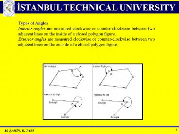
Types of Angles Interior angles are measured
clockwise or counter-clockwise between two
adjacent lines on the inside of a closed polygon
figure. Exterior angles are measured clockwise or
counter-clockwise between two adjacent lines on
the outside of a closed polygon figure.
2
Azimuth The azimuth of a line on the ground is
its horizontal angle measured from the meridian
to the line. Azimuth gives the direction of the
line with respect to the meridian. It is usually
measured in a clockwise direction with respect to
either the north meridian or the south meridian.
In plane surveying, azimuths are generally
measured from the north. When using azimuths, one
needs to designate whether the azimuth is from
the north or the south. Azimuths are called as
true (astronomical) azimuths, magnetic
azimuths, grid azimuths, or assumed azimuths
depending on the type of meridian
referenced. Azimuths may have values between 0
and 360 degrees.
3
The azimuth from the North for each line is
4
Bearings The bearing of a line also gives the
direction of a line with respect to the reference
meridian. The bearing states whether the angle is
measured from the north or the south and also
whether the angle is measured toward the east or
west. For example, if a line has a bearing of S
47 E, the bearing angle 47 is measured from the
south meridian eastward. A stated bearing is said
to be a true bearing, a magnetic bearing, an
assumed bearing, or a grid bearing, according to
the type of meridian referenced.
5
The bearing for each line is
6
Relation between Bearing and Azimuth To simplify
computations based on survey data, bearings may
be converted to azimuths or azimuths to bearings.
7
Leveling DEFINITIONS To measure the difference
in height (?H) between two points A and B,
vertical rods are set up at each of these two
points and a level somewhere between them. The
height difference between A and B is the
difference between the rod (staff) readings.
8
?HAB l2 - l1
9
(No Transcript)
10
Plumb line
P
H
g
Geoid WWo
Level surface W constant
11
(No Transcript)
12
(No Transcript)
13
(No Transcript)
14
(No Transcript)
15
(No Transcript)
16
(No Transcript)
17
(No Transcript)
18
Earth surface level surface W
const. Geoid W Wo
19
(No Transcript)
20
(No Transcript)
21
(No Transcript)
22
(No Transcript)
23
Rod
Upper hair Center hair Lower hair
24
1st setup
2nd setup
MEAN SEA LEVEL (GEOID)
3rd setup
MEAN SEA LEVEL (GEOID)
25
(No Transcript)
Recommended
CrystalGraphics Presentations


