
Accuracy Assessment - PowerPoint PPT Presentation
1 / 24
Title:
Accuracy Assessment
Description:
You need to tell your boss how well it actually represents ... You may need aerial photos or even other satellite images. Accuracy Assessment: Reference Data ... – PowerPoint PPT presentation
Number of Views:227
Avg rating:3.0/5.0
Title: Accuracy Assessment
1
Accuracy Assessment
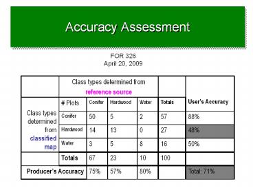
FOR 326 April 20, 2009
Class types determined from reference source Class types determined from reference source Class types determined from reference source Class types determined from reference source Users Accuracy
Class types determined from classified map Plots Conifer Hardwood Water Totals Users Accuracy
Class types determined from classified map Conifer 50 5 2 57 88
Class types determined from classified map Hardwood 14 13 0 27 48
Class types determined from classified map Water 3 5 8 16 50
Totals 67 23 10 100
Producers Accuracy Producers Accuracy 75 57 80 Total 71
2
Accuracy Assessment
- The Situation
- Youve just created a classified map for your
boss - You need to tell your boss how well it actually
represents whats out there - Without an accuracy assessment, a classified map
is just a pretty picture.
3
(No Transcript)
4
(No Transcript)
5
Accuracy Assessment
- Goals
- Assess how well a classification worked
- Understand how to interpret the usefulness of
someone elses classification
6
Accuracy Assessment
- Overview
- Collect reference data ground truth
- Determination of class types at specific
locations - Compare reference to classified map
- Does class type on classified map class type
determined from reference data?
7
Accuracy Assessment Reference Data
- Some possible sources
- Aerial photo interpretation
- Ground truth with GPS
- GIS layers
8
Accuracy Assessment Reference Data
- Issue 1 Choosing reference source
- Make sure you can actually extract from the
reference source the information that you need
for the classification scheme - I.e. Aerial photos may not be good reference data
if your classification scheme distinguishes four
species of grass. You may need GPSd ground data.
9
Accuracy Assessment Reference data
- Issue 2 Determining size of reference plots
- Match spatial scale of reference plots and
remotely-sensed data - I.e. GPSd ground plots 5 meters on a side may
not be useful if remotely-sensed cells are 1km on
a side. You may need aerial photos or even other
satellite images.
10
Accuracy Assessment Reference Data
- Issue 2 Determining size of reference plots
- Take into account spatial frequencies of image
- E.G. For the two examples below, consider photo
reference plots that cover an area 3 pixels on a
side
Example 1 Low spatial frequency Homogeneous image
Example 2 High spatial frequency Heterogenous
image
11
Accuracy Assessment Reference Data
- Issue 2 Determining size of reference plots
- HOWEVER, also need to take into account accuracy
of position of image and reference data - E.G. For the same two examples, consider the
situation where accuracy of position of the image
is /- one pixel
Example 1 Low spatial frequency
Example 2 High spatial frequency
12
Accuracy Assessment Reference Data
- Issue 3 Determining position and number of
samples - Make sure to adequately sample the landscape
- Variety of sampling schemes
- Random, stratified random, systematic, etc.
- The more reference plots, the better
- You can estimate how many you need statistically
- In reality, you can never get enough
- Lillesand and Kiefer suggest 50 per class as
rule of thumb
13
Sampling Methods
Stratified Random Sampling
a
minimum number of observations
are randomly placed in each
category.
14
Sampling Methods
15
Accuracy Assessment Reference data
- Having chosen reference source, plot size, and
locations - Determine class types from reference source
- Determine class type claimed by classified map
- Compare them!
16
Accuracy Assessment Compare
- Example
Reference Plot ID Number Class determined from reference source Class claimed on classified map Agreement?
1 Conifer Conifer Yes
2 Hardwood Conifer No
3 Water Water Yes
4 Hardwood Hardwood Yes
5 Grass Hardwood No
6 Etc.
17
Accuracy Assessment Compare
- How to summarize and quantify?
18
Accuracy Assessment Error matrix
- Summarize using an error matrix
Class types determined from Morgantown Aerial Photo Class types determined from Morgantown Aerial Photo Class types determined from Morgantown Aerial Photo Class types determined from Morgantown Aerial Photo
Class types determined from Unsupervised classifcation Plots Water Pavement Forest Totals
Class types determined from Unsupervised classifcation Water 10
Class types determined from Unsupervised classifcation Pavement 10
Class types determined from Unsupervised classifcation Forest 10
Totals 30
19
Accuracy Assessment Total Accuracy
- Quantifying accuracy
- Total Accuracy Number of correct plots / total
number of plots
Class types determined from reference source Class types determined from reference source Class types determined from reference source Class types determined from reference source
Class types determined from classified map Plots Conifer Hardwood Water Totals
Class types determined from classified map Conifer 50 5 2 57
Class types determined from classified map Hardwood 14 13 0 27
Class types determined from classified map Water 3 5 8 16
Totals 67 23 10 100
Diagonals represent sites classified correctly
according to reference data Off-diagonals were
mis-classified
20
Accuracy Assessment Total Accuracy
- Problem with total accuracy
- Summary value is an average
- Does not reveal if error was evenly distributed
between classes or if some classes were really
bad and some really good
21
Accuracy Assessment Interpreting
- Why might accuracy be low?
- Errors in reference data
- Errors in classified map
22
Accuracy Assessment Interpreting
- Errors in reference data
- Positional error
- Better rectification of image may help
- Interpreter error
- Reference medium inappropriate for classification
23
Accuracy Assessment Interpreting
- Errors in classified map
- Remotely-sensed data cannot capture classes
- Classes are land use, not land cover
- Classes not spectrally separable
- Atmospheric effects mask subtle differences
- Spatial scale of remote sensing instrument does
not match classification scheme
24
Accuracy Assessment Improving Classification
- Ways to deal with these problems
- Land use/land cover incorporate other data
- Elevation, temperature, ownership, distance from
streams, etc. - Context
- Spectral inseparability add spectral data
- Hyperspectral
- Multiple dates
- Atmospheric effects Atmospheric correction may
help - Scale Change grain of spectral data
- Different sensor
- Aggregate pixels