
Image Processing Division - PowerPoint PPT Presentation
1 / 1
Title:
Image Processing Division
Description:
The system provides tools that allow automatic registration and mosaic of remote sensing images. ... Aerial video sequence mosaic, 720x480, Amazon, Brazil ... – PowerPoint PPT presentation
Number of Views:22
Avg rating:3.0/5.0
Title: Image Processing Division
1
AUTOMATIC REGISTRATION AND MOSAICKING SYSTEM FOR
REMOTELY SENSED IMAGERY Dmitry Fedorov
ltfedorov_at_dpi.inpe.brgt, Leila M.G. Fonseca
ltleila_at_dpi.inpe.brgt, Charles Kenney
ltkenney_at_ece.ucsb.edugt, B.S. Manjunath
ltmanj_at_ece.ucsb.edugt.
1. System The developed registration system is a
full featured application intended for beginners
and advanced users. Registration may be achieved
by one simple click or may be controlled by
several parameters. The system provides tools
that allow automatic registration and mosaic of
remote sensing images. It is designed to accept
different types of data (TM, SPOT, JERS, etc.)
and information provided by the user that are
used to speed up the processing or avoid
mismatched control points. A statistical
procedure is used to characterize good and bad
registrations. Based on this good fit-bad fit
statistical testing the user can stop or modify
the parameters and continue the processing.
3. Registration Registration procedure needs only
one parameter quality. For standard algorithm it
specifies the number of tie points to start with.
This parameter is only modified in more
complicated registration cases (images with
clouds, severe temporal changes, very different
sensors) and decreases registration speed
exponentially. However, reasonable number of tie
points (128) returns almost instant result.
There are three registration algorithms
implemented optical flow and geometry (Kenney),
wavelet (Fonseca) and contours (Li).
Registration can be done through selected by
user rectangles instead of using whole images.
This is useful in cases with dense cloudiness,
multi-temporal ocean shots, etc.
Mosaic procedure contains several useful features
like mosaic both images into separate channels
for match verification, equalize the images using
simple mean and standard deviation comparation of
the overlapping area, etc.
System accepts most popular image formats (BMP,
GIF, JPEG, PNG, RAW, TIFF, GeoTIFF, etc.) and
some of mosaic results can be saved as GeoTiff
images.
2. Toolboxes System contains toolboxes what
increase the registration strength using users
knowledge. Theres input images pre-processing
what can change image resolution, select a
specific band, enhance histogram, etc.
The system is developed with multi-platform use
in mind. It is written using common C and
Trolltech Qt library and have been compiled and
used under Solaris, Linux and Windows.
Tie points can be edited in powerful embedded
editor or exported to external applications.
Internal editor visualizes useful information
like differences between points, mean squared
error of all or selected points. Selected points
may be showed on the images.
In order to simplify image viewing and handling a
universal viewer was developed. It provides basic
read/write and preview operations, such as load
file, save file, change zoom, image information,
full screen preview, clipboard handling, etc.
Visualization module also contains a layer to
handle special information like tie points,
rectangles, etc.
4. Conclusions and Tests Extensive algorithm
tests have been performed by registering optical,
radar, multi-sensor, high-resolution images and
video sequences. We have included very difficult
image registration examples in order to show the
strengths and limits of our approach. A
registration system online demo have been
developed (http//regima.dpi.inpe.br),
(http//nayana.ece.ucsb.edu/registration) it
contains several examples that can be executed
using web browser.
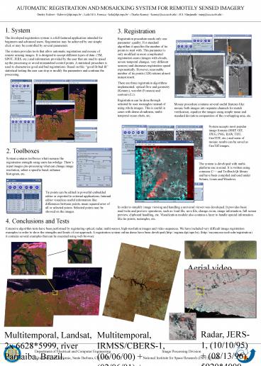
Aerial video sequence mosaic, 720x480, Amazon,
Brazil
Radar, JERS-1, (10/10/95) (08/13/96),
59204000, Amazon, Brazil.
Multitemporal, IRMSS/CBERS-1, (06/06/00)
(02/06/01) (19/08/01), 4x 16051735, São Paulo,
Brazil.
Multitemporal, Landsat, 2x 66285999, river
Parnaiba, Brazil.
Image Processing Division National Institute for
Space Research (INPE), Brazil.
Department of Electrical and Computer
Engineering University of California, Santa
Barbara, CA, USA.
Recommended
CrystalGraphics Presentations


