
The AIRSAR Instrument - PowerPoint PPT Presentation
1 / 11
Title:
The AIRSAR Instrument
Description:
Volcano study in Aleutians and Kamchatka; topographic change; filling voids in SRTM coverage. Alaska/Canada Tundra; Ice studies in Arctic, Beaufort Sea, grounding ... – PowerPoint PPT presentation
Number of Views:94
Avg rating:3.0/5.0
Title: The AIRSAR Instrument
1
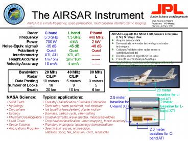
The AIRSAR Instrument
AIRSAR is a multi-frequency, quad-polarization,
multi-baseline interferometric imaging radar.
- AIRSAR supports the NASA Earth Science Enterprise
(ESE) Strategic Plan - Acquire science data.
- Demonstrate new radar technology and radar
techniques. - Calibrate/Validate other radar sensors
satellitesuborbital - Develop science algorithms for radar.
- Promote international partnerships.
- Each of these activities is directly geared
towards addressing ESE science questions.
Typical applications
NASA Science
- Forestry Classification / Biomass Estimation
- River rates, snow pack/melt, soil moisture
- Ice type/thickness/extent, glacier motion
- Biomass, carbon cycle, clear-cutting
- Coastal currents, wave spectra, mesoscale eddies
- Crop health/classification, urban mapping, forest
inventory - Planetary analogues, technology demonstrations
- Search and rescue, archaeology,
- Hazards flood, fire, pollution, UXO, landslides
- Solid Earth
- Hydrology
- Cryosphere
- Ecology
- Physical Oceanography
- Land Cover
- Space Science
- Applications Program
2
AirSci 2002
Flight Request S. Cal Eddies CLPX GLAWEX Planetary
Analogues Deformation Studies I Fire
Hazards Search and Rescue I Search and Rescue
II SRTM Validation Deformation Studies II River
Altimeter Forest Studies DOD Archaeology SMEX Mars
Sciencecraft
PI Holt Cline Leshkevich Campbell Fielding Denniso
n, Weissel GSFC Dryden/GSFC Zebker Webb Rodriguez
Dobson Blom Jackson, Njoku Davies
Discipline Polar Science Code YS Hydrology Polar
Science/Hydrology Code SR Solid Earth and Natural
Hazards Code YO Code YO Code YO Solid Earth and
Natural Hazards Solid Earth and Natural
Hazards Code YS Hydrology Code YS Ecology / Code
YO Reimbursable DoD Code YS Hydrology Code S
3
SMEX02
Initally, dry condition
After light rainfall
After heavy rainfall
SMEX02 Field HQ
Dry-down
Further Dry-down
A set of five AIRSAR flights were acquired over
the SMEX experimental and regional sites,
compassing a series of thundershowers with an
initial dry period and a post-rain dry-down
period. These data were collected as part of an
intensive field and multi-sensor air campaign.
4
Cold Land Processes Experiment Snowfall-Induced
Change
Fraser 270-1 before-snow, just after snow, and
during snow-melt.
23 Feb 02
21 Feb 02
19 Feb 02
5
ATI for Surface Hydrology
Data acquired over Columbia and Missouri Rivers.
Principal Investigators
Delwyn Moller JPL Ernesto Rodriguez JPL
m/s
Research Objective
Demonstrate the feasibility of a future
spaceborne system which could use along-track
interferometry to measure river velocities and
cross-track interferometry for water level
measurements. Applications would include
dB
m/s
6
Great Lakes Winter Experiment Ice
Type/Thickness/Breakup
L
C
R
Whitefish Bay, Lake Superior
L CHH CHV CVV C LHH LHV LVV R PHH PHV PVV
L PHH LHH CHH C PHH LHV CHV R PVV LVV CVV
L PTP LTP CTP C PHH LHV CVV R PVV LHV CHH
7
IceSAR02 Ocean
Eddy Studies off the Coast of Southern CA
Principal Investigators
ERS Imagery
- Ben Holt, JPL
- Paul DiGiacomo, JPL
Research Objective
- Map eddy structure via oily slicks interested
in generation, persistence, recurrence,
rotational and translational speeds. - Measure river outflow / storm water discharge and
impact on productivity. - Same-day data acquisition with Radarsat and ERS
for comparison.
AIRSAR L-band Along-Track Interferometry
8
AIRSAR Technology
Implemented in 2002
Planned for 2003
- New Digital Chirp Generators (Mars)
- New P-band Transmitter (3dB)
- New EGI Firmware
- Real-Time Differential GPS (lt14 cm)
- Quick-look interferometry and polarimetry
- Co-registered multi-frequency at differing
bandwidths (40/40/20 and 80/80/40)
- Demonstrate new digital subsystem three-times
the data-rate--gtwider high-res swath / better
SNR. - Add two C-band receivers to allow simultaneous
POLSAR/TOPSAR/ATI with multiple-baselines
simultaneous co-pol and cross-pol interferometry. - Demonstrate airborne repeat-pass interferometry
processing capability.
9
DC-8 Schedule for 2003
SMEX03
SMEX03
NRL ATI
10
Data Acquisition Plans
- Feb03 - Apr03 CLPX03, Mars ASE, SAR2
- May03 - Jun03 ECOSAR03 (Central America)
- Jun03 - Jul03 SMEX03
- Jul03 - Aug03 NRL ATI
- Feb04 - Apr04 CLPX04
- 2004-2005 SHEX04 / SHEX05 ?
- Jun04 - Jul04 LBA (Amazon) (not likely)
- Dec04 - Feb05 Pole-to-Pole Mission
- Sep05 Earthscope
- Jun06 - Jul06 Earthscope
See http//www.dfrc.nasa.gov/airsci/dc85yr.html (N
ote that the calendar at this link is not
necessarily always up-to-date.)
11
Pole-to-Pole Mission
Tentative schedule Dec 2004- Feb 2005
- Candidate Science Objectives
- Volcano study in Aleutians and Kamchatka
topographic change filling voids in SRTM
coverage. - Alaska/Canada Tundra Ice studies in Arctic,
Beaufort Sea, grounding line in Antarctic,
Patagonia glaciers - Monsoon season in Australia (flooding)
- Tropical forest studies (biomass and carbon
cycle) South and Central America, SE Asia
(Thailand, Cambodia, Malaysia) - Opposite season from previous campaigns in SE
Asia and Australia for change in land cover,
flood plains - Kuroshio current and related eddies, eddies spun
off from Antarctic circumpolar current
Suggested Goals
- Study of new-generation AIRSAR datasets for
scientific and algorithm development. - Data fusion with additional co-mounted
instruments e.g., MASTER, PSR - Cal/Val with spaceborne datasets ALOS/PalSAR,
RadarSAT II. - Algorithm development for Hydros
Regions of Study
- Arctic
- Aleutians
- Kamchatka
- Central/South America
- Antarctic
- Australia and SE Asia
20 meter height wrap, near Angkor, Cambodia
Recommended
CrystalGraphics Presentations


