
GIS Modeling - PowerPoint PPT Presentation
Title:
GIS Modeling
Description:
The logical sequence of map analysis operations is ... graphy. Flood- plane. Public. Lands. Existing. Utilities. Trans- poration. Land. Cover. Proximity ... – PowerPoint PPT presentation
Number of Views:51
Avg rating:3.0/5.0
Title: GIS Modeling
1
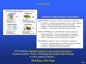
GIS Modeling
GIS Modeling logically sequences map analysis
operations (Spatial Analysis, Surface Modeling
and Spatial Data Mining) to solve spatial
problems Thinking with Maps
(Berry)
2
Decision Support Systems Framework
(Berry)
3
Suitability Modeling (Full Exercise 8)
(Berry)
4
Capturing Model Logic (Command Script)
The logical sequence of map analysis operations
is contained in a Command Script that can be
easily changed to simulate different scenarios
(Berry)
5
Suitability Modeling (Comparing Scenarios)
(Berry)
6
Transmission Line Siting Model
(Berry)
7
Siting Model Flowchart (Model Logic)
Model logic is captured in a flowchart where the
boxes represent maps and lines identify
processing steps leading to a spatial solution
(Berry)
8
Siting Model Flowchart (Model Logic)
Model logic is captured in a flowchart where the
boxes represent maps and lines identify
processing steps leading to a spatial solution
(Berry)
9
Step 1 Discrete Preference Map
(Berry)
10
Step 2 Accumulated Preference Map
Splash Algorithm like tossing a stick into a
pond with waves emanating out and accumulating
costs as the wave front moves
(Berry)
11
Step 3 Most Preferred Route
(Berry)
12
Generating Optimal Path Corridors
(Berry)
13
Power and Pipeline Routing (Advanced GIS Models)
(Berry)
14
Real World Routing Application (Processing
Schematic)
B E N (avg)
B E N
B E N
B E N
Built
Engr.
Natural
Excluded
Hydro- graphy
Flood- plane
Public Lands
Existing Utilities
Trans- poration
Land Cover
Proximity Excluded
Proximity Buildings
Building Density
Visual Exposure
Proximity Schools
Slope
(Berry)
15
Identifying the Routing Decision Space
Combining alternative corridors identifies the
decision space reflecting various perspectives
the routing decision space is identified by
combining the Alternative Corridors
GeoWorld magazine feature article on the EPRI_GTC
project http//www.geoplace.com/gw/2004/0404/0404p
wr.asp
16
Acquire Additional Detailed Field Data
The Siting Team collects additional very detailed
field data within the decision space defined by
the Alternative Corridors
17
Investigating the Alternative Routes (GIS-derived
)
Standardized Alternative Routes Built Natural Engi
neering Simple
Simple Discrete Preference Surface shown as
background avoid areas in warmer tones
(red) and favor locating in
cooler tones (green)
Built-up Area (avoid)
Less Suitable
Open Field (favor)
More Suitable
Note if the additional detailed data warrants,
the Siting Team can re-locate portions of the
GIS-derived Alternative Routes but a formal
statement of the reasons are required alignment
of a potential route outside of the decision
space requires an exception petition (analogous
to land use re-zoning)
18
Evaluating Potential Routes (selecting the
Preferred)
the relative merits of top few potential routes
are discussed by the Siting Team and then ranked
to identify the most preferred route
19
The Softer Side of GIS (Beyond Mapping III Epilog)
Where we have been in GIS
Where we are headed in GIS
20
Where Have We Been?
- Computer Mapping -- Spatial dB Management -- GIS
Modeling
- Surface Modeling maps the spatial
distribution and - pattern of point data (Map Generalization,
Spatial Interpolation - and Others)
- Data Mining numerical relationships
- within and among mapped data (Descriptive,
Predictive, - and Prescriptive)
(Berry)
21
More on Map Analysis and GIS Modeling
(Berry)