
II' LARGE LANDFORMS AND PLATE TECTONICS - PowerPoint PPT Presentation
1 / 27
Title:
II' LARGE LANDFORMS AND PLATE TECTONICS
Description:
The theory that helps to explain how the world's large landforms were formed ... Kanaga Volcano in Alaska. Secondary landforms are formed by the forces of erosion ... – PowerPoint PPT presentation
Number of Views:116
Avg rating:3.0/5.0
Title: II' LARGE LANDFORMS AND PLATE TECTONICS
1
II. LARGE LANDFORMS AND PLATE TECTONICS
2
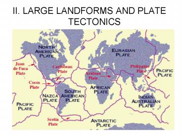
A. Plate tectonics
The theory that helps to explain how the worlds
large landforms were formed
If you look at the world map shown above, you may
notice that some of the continents could fit
together like pieces of a puzzle.
3
A. Plate tectonics
Earths crust is divide into more than a dozen
rigid, slow-moving plates that move a tiny amount
each year
4
A. Plate tectonics
The plates can be from 6 to 60 miles thick
5
Scientists use the theory of plate tectonics to
explain the history of Earths surface
A. Plate tectonics
6
Scientists have determined that about 200 million
years ago, there was one supercontinent called
Pangaea
A. Plate tectonics
7
Pangaea broke into two smaller supercontinents
Laurasia and Gondwanaland
A. Plate tectonics
8
A. Plate tectonics
Laurasia and Gondwanaland then split into the
modern continents
9
B. Plate boundaries
There are three types of plate boundaries a.
Plates moving away from one another b. Plates
pushing against one another c. Plates sliding
past one another
10
B. Plate boundaries
Where plates move away from each other, the crust
is lifted up and forms a chain of mountains
called a mid-ocean range
11
B. Plate boundaries
The mid-ocean range extends more than 40,000
miles and occasionally forms islands
12
B. Plate boundaries
Abyssal plains are found on the ocean floors
The abyssal plain (the term abyssal refers to the
large, deep parts of the ocean) is the feature
that constitutes the largest portion of the ocean
floor. It has been compared to the great flat
prairie lands of mid-America.
13
B. Plate boundaries
Trenches are formed when a heavier plate slides
under another plate and sinks into the upper
mantle
14
B. Plate boundaries
Trenches can be more than 600 miles wide and 7
miles deep and are the oceans deepest places
15
C. Landforms resulting from colliding plates
When one plate has a continent, the lighter rocks
of the continent crumple and form a mountain
range (Andes Mountains)
16
C. Landforms resulting from colliding plates
When two plates carrying continents collide, the
rocks of the continents move together and build
huge mountains (the Himalayas)
17
C. Landforms resulting from colliding plates
When plates pass one another, low mountains may
result (San Andreas Fault system)
18
III. Landform Development
Devils Tower National Monument
19
A. Primary landforms
Primary landforms are masses of rock raised by
volcanic or tectonic forces
Kanaga Volcano in Alaska
20
B. Secondary landforms
Secondary landforms are formed by the forces of
erosion
Monument Valley, AZ
21
B. Secondary landforms
Erosion wears down the surface of primary
landforms
22
B. Secondary landforms
Older secondary landforms have less relief than
younger ones
Smoky Mountains
Rocky Mountains
23
C. Types of landforms
Valleys, plains, and plateaus are rock with a
thin layer of weathered sediments and soil at the
surface
24
C. Types of landforms
Desert sand dunes and floodplains have sediments
deposited by water, wind, or ice
25
C. Types of landforms
Tectonic activity forms mountains, sunken
valleys, and ocean trenches
26
D. Landforms affect people
Landforms have influenced human settlement
throughout history
27
D. Landforms affect people
The earth is constantly changing - Mud slides
wipe out roads or villages volcanic lava
threatens towns floods change the terrain
Recommended
CrystalGraphics Presentations


