
Land Covers of Duhok City - PowerPoint PPT Presentation
Title:
Land Covers of Duhok City
Description:
Land Covers of Duhok City – PowerPoint PPT presentation
Number of Views:80
Title: Land Covers of Duhok City
1
Land Covers of Duhok City Zakaria Namq Shant
Robein University of Dohuk, Spatial Planning
Department
Abstract Methods and Materials
Discussion
At various scales, including local, regional,
national, and global, the Earth's surface is
constantly changing. Land use and land cover
changes are widespread, quick, and can have
enormous consequences for people, the economy,
and the environment. Users in the domains of
urban planning, land management, and natural
resource conservation now have access to
current, reliable, and cost-effective ways for
acquiring information regarding landscape
change. This poster provides 5 types of land
covers with the importance of knowledge of these
covers and the impact that these covers may
cause on the environment of Duhok city.
In order to obtain data and prepare up-to-date
maps of land cover, with the
now, current, accurate, and cost-effective
methods for gathering information about
landscape change have become available to users
in the fields of urban planning, land
management, and natural resource conservation. As
it shown in the figures before (showed in
results), and with up-to-date maps it's suitable
now to compare it to previous or future maps to
see the changes in land cover and be ready and
prepared to solve issues regarding urban sprawl
and land-use changes in agricultural fields
or/and urban areas. See the changes in water
bodies are important for water studies to
indicate whether water level is increasing or
decreasing in annually or monthly basis. These
maps help the responsible authorities to scan the
land for the purpose of illegal land using and
forest fire and it impacts on the environment.
use of some applications and satellite websites
it's possible to provide these maps. First we
download satellite image of Duhok city via USGS
website then with the use of ArcMap to create
the maps. After that, classification of the land
cover in 5 cover types (water bodies, forest,
croplands, urban area and rocks) with selecting
suitable colors to specify them. In addition, an
appropriate maps of land of Duhok city is
provided in Results.
Introduction
Knowledge of the existing state of the landscape
is required for land management and planning.
Any individual in charge of land management must
have a thorough understanding of present land
cover and how it is used, as well as a reliable
method of tracking change through time. Land
cover mapping, a method that quantifies present
land resources into a variety of thematic
categories such as forest, water, and paved
surfaces, makes it
Acknowledgements
Thanks to Mrs. Jwan M. Aldoski Dr. Mohammed
Jalal. For giving us GIS Course.
References
Purdue Writing Lab. (n.d.). Reference List
Electronic Sources //
simple to measure present circumstances and how
they are evolving. Sanborn provides a
cost-effective and accurate way to extract land
resource information and retain its currency in
the future by using remotely sensed imagery and
semi-automated classification procedures. Hence,
the lack of these up-to-date
Purdue Writing Lab. Purdue Writing Lab.
https//owl.purdue.edu/owl/research_and_citation/a
pa_style/apa _formatting_and_style_guide/reference
_list_electronic_sources.h tml.
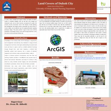
Results
Figure below shows the land covers of Duhok city.
University of Duhok
information may cause some serious problem such
as environment and research organizations, water
district, land-use changes, urban sprawl and
Engineering firms.
Figure1 Land covers types. Source (European
Commission, 2021)
Contact Zakaria Namq Shant Robein
UOD Duhok City TP019.zakaria.akrayi_at_gmail.co
m tp019.shant.roben.kindalo_at_gmail.com
Zakaria 07504265929 Shant 07508339094
Supervisor Dr. Jwan M. Aldoski