
San Francisco Ocean BeachGreat Highway Erosion Control Project - PowerPoint PPT Presentation
1 / 18
Title:
San Francisco Ocean BeachGreat Highway Erosion Control Project
Description:
Golden Gate National Recreation Area (GGNRA, a unit of the National Park Service ... California Coastal Commission (CCC) - state agency with primary regulatory ... – PowerPoint PPT presentation
Number of Views:35
Avg rating:3.0/5.0
Title: San Francisco Ocean BeachGreat Highway Erosion Control Project
1
San FranciscoOcean Beach-Great Highway Erosion
Control Project
2
Historic Shoreline
- Historically, the Ocean Beach shoreline was
situated several hundred feet landward of its
current location. - Development in the 1800s and early 1900s moved
the shoreline seaward. - Winter storms have eroded significant portions of
the shoreline. - From the Cliff House south, there are a number of
seawalls and natural landforms that limit
storm-generated impacts to public facilities. - The approximately 3,000-foot section of Ocean
Beach that stretches from Sloat Boulevard to Fort
Funston is vulnerable to erosion.
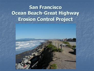
3
The Problem Area
- Artificial bluff material form the
1940-1960s(concrete debris, bricks, soil and
sand), formed a wide enough barrier between the
Great Highway and the ocean that erosion was not
a perceived problem - Since 1995, however, winter storms have eroded
large areas of the man-made bluffs, which consist
mostly of fill material from historic
development, resulting in the loss of parking
spaces within GGNRA, as well as threats to the
Great Highway
4
The Problem Area
5
The Problem Area
6
The Partnership
- The City and County of San Francisco (CCSF),
through the Department of Public Works (DPW), is
partnering with - U. S. Army Corps of Engineers (USACE)
- Golden Gate National Recreation Area (GGNRA, a
unit of the National Park Service - California Department of Boating and Waterways
- United State Geological Survey (USGS)
7
Long Term Goal
- Develop long-term solutions to beach and bluff
erosion problems on park and city property along
the Great Highway. Solutions evaluated need to be
consistent with federal and state regulations
that support the enhancement of natural
processes.
8
Study Area
9
Timeline of Actions
- From 1997 to 2000 CCSF has funded several
temporary/emergency projects including a 600 foot
rock revetment to protect City infrastructure. - In response to concerns that "hard structure"
alternatives are detrimental, the City spent
1,300,000 for sand placement and monitoring
reports. - In 2001 an emergency detour lane was constructed
to carry traffic in the event of damage to the
Great Highway. - In 2000, the Mayors Office created the Ocean
Beach Task Force to bring the public and the many
governmental stakeholders together - DPW received grant funding from the California
Department of Boating and Waterways and technical
assistance from USACE to continue seeking a
long-term solution to Ocean Beach issues that is
compatible with National Park Service and other
agency mandates (cont)
10
Timeline of Actions
- In 2002, the San Francisco Commission on the
Environment passed a resolution encouraging DPW
and the other cooperating agencies to continue
monitoring the beach and bluffs south of Sloat
Blvd. The Commission also encouraged continued
public involvement through the alternatives
evaluation process - In 2004 DPW began transporting between 10,000 and
15,000 cubic yards of sand from the Noriega
Seawall to the most several erosion area South of
Sloat Blvd. - In 2005 An Ocean Beach Great Highway Storm Damage
Protection report was completed. This report
outlined a project that focuses on the beneficial
reuse of Dredged materials from the San Francisco
Ship channel - 2005 to 2007 The Army Corps dredged and disposed
of over 300,000 Cubic Yards of sand from the San
Francisco Ship Channel and placed near shore
11
Public Agencies Involved in Ocean Beach Project
Planning
- Golden Gate National Recreation Area (GGNRA) - a
unit of the National Park System owns and manages
Ocean Beach since it was transferred by the San
Francisco Recreation and Parks Department in the
1970s. - California Coastal Commission (CCC) - state
agency with primary regulatory jurisdiction along
the California coastline within 100 feet of the
high tide line. - U. S. Army Corps of Engineers (USACE) - federal
agency with Congressionally-mandated authority to
cost-share in economically justified projects
that comply with existing Federal laws, policies
and regulations in its primary mission areas,
which are commercial navigation, flood damage
reduction, shoreline protection and ecosystem
restoration.
12
Public Agencies Involved in Ocean Beach Project
Planning
- San Francisco Recreation and Parks Department -
owner of the Great Highway, - San Francisco Public Utilities Commission (SFPUC)
- operates the wastewater treatment facilities
that are under the Great Highway and the
easements through the Highway and the Beach to
outfall facilities. - San Francisco Department of Public Works (DPW) -
department that has implemented emergency actions
to control bluff erosion, To date the DPW has
requested and received permit approvals from the
California Coastal Commission and or the GGNRA
for the placement of the quarry stone revetment,
the sand barrier and beach/bluff top markers
placed on federal Property. - San Francisco Department of the Environment (DOE)
- co-chaired the Ocean Beach Task Force and
provides support for ongoing Ocean Beach planning
and community involvement efforts.
13
Technical Effort
- Since 1996 monitoring reports have been prepared
on measuring bluff retreat and seasonal variable
beach elevation - The USGS has performed extensive current and sea
floor mapping to determine the sediment transport
with in the San Francisco Bay cell - The Army Corps of Engineers have initiated a
beneficial reuse of dredge material study under
Section 933 of the Water Resources Development
Act - DPW has initiated a technical study on and
suitable material for Beach restoration dune
designs
14
The Potential Solutions
15
Sand Transport Model
16
Potential Solutions
- Investigate the beneficial reuse of dredged
material (beach quality sand) - Evaluate Beach Nourishment project that will use
dredged material from the existing Bar Channel
Navigation Project - Identify areas of excess sand at ocean beach
that can be safely transported to the erosion
area
17
The Goal
- BEFORE AFTER
18
(No Transcript)