
Traditional Photogrammetry vs. LiDAR - PowerPoint PPT Presentation
1 / 21
Title:
Traditional Photogrammetry vs. LiDAR
Description:
Digital photogrammetry applications: ... LiDAR and digital aerial photography. http://pugetsoundlidar.ess.washington.edu/example1.htm ... – PowerPoint PPT presentation
Number of Views:1045
Avg rating:3.0/5.0
Title: Traditional Photogrammetry vs. LiDAR
1
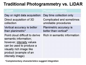
Traditional Photogrammetry vs. LiDAR
Complementary characteristics suggest
integration
2
What are some of the LIDAR data products
available?
- Digital Ortho-Rectified Imagery
- Some LiDAR providers collect digital color or
black-and-white ortho-rectified imagery
simultaneously with the collection of point data.
Imagery is collected either from digital cameras
or digital video cameras and can be mosaiced.
Resolution is typically 1m. - Intensity Return Images
- Images may be derived from intensity values
returned by each laser pulse. The intensity
values can be displayed as a gray scale image. - LIDAR Derived Products
- Topographic LiDAR systems produce surface
elevation x, y, z coordinate data points. There
are many products that can be derived from raw
point data. Most LiDAR providers can derive these
products upon request - Digital Elevation Models (DEMs)
- Digital Terrain Models (DTMs) (bald-earth
elevation data) - Triangulated Irregular Networks (TINs)
- Breaklines - a line representing a feature that
you wish to preserve in a TIN (example stream or
ridge) - Contours
- Shaded Relief
- Slope Aspect
3
Intensity Image
- Commonly unused bi-product of a LiDAR acquisition
and is the intensity of object that the laser
pulse is striking. This is an uncalibrated 8-bit
(0-255) image that is ortho-rectified as
therefore can be used as an orthophoto - Not typically used in quantitative analysis as
image gains always set to 'adaptive gain' setting
when images are acquired
4
http//www.sbgmaps.com/lidar.htm
5
http//ilmbwww.gov.bc.ca/bmgs/pba/trim/specs/LiDAR
Specifications ver 0.5.pdf
Intensity images. Similar in appearance to
low-resolution photographs, georeferenced lidar
intensity images can be used to extract
planimetric features and serve as ancillary input
for lidar data processing. Intensity images also
are used to check the horizontal accuracy of the
lidar data and other criteria.
6
Digital photogrammetry applicationshttp//www.gi
sdevelopment.net/proceedings/mapmiddleeast/2007/te
chnology/3DVisualisation/mme07_Malmberg.pdf
7
Digital photogrammetry software
http//www.cardinalsystems.net/vrtwo.htm
8
http//ilmbwww.gov.bc.ca/bmgs/airphoto/specs/DIGIT
AL_AERIAL_PHOTOGRAPHIC_IMAGES_SPECS_05022008.pdf
9
Terrasaurus, Williams Lake http//terrasaurus.ca/
terrasaurus/about.html
10
Selkirk Remote Sensing ltd, Richmond
BChttp//www.selkirk.com/NewPhotography.php
11
http//apps.ecy.wa.gov/shorephotos/
12
LiDAR applications
13
http//www.gisdevelopment.net/proceedings/mapmiddl
eeast/2007/technology/3DVisualisation/mme07_Malmbe
rg.pdf
14
(No Transcript)
15
Representing the relief of Orienteering maps with
the aid of airborne laser scanning
Höhendarstellung in OL-Karten mithilfe von
Airborne Laser-Scanning
Thomas Hohl Gymnasium Kirschgarten Basel
16
LIDAR basemaps for Orineteering
http//www.lidarbasemaps.org/
Hill shading
17
O-map with hill shading
18
Map hill slope
19
LiDAR and digital aerial photographyhttp//pugets
oundlidar.ess.washington.edu/example1.htm
20
(No Transcript)
21
(No Transcript)
Recommended
CrystalGraphics Presentations


