
Briefing for the Office of Senator Harry Reid - PowerPoint PPT Presentation
1 / 34
Title:
Briefing for the Office of Senator Harry Reid
Description:
Briefing for the Office of Senator Harry Reid – PowerPoint PPT presentation
Number of Views:51
Avg rating:3.0/5.0
Title: Briefing for the Office of Senator Harry Reid
1
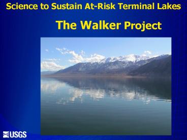
Science to Sustain At-Risk Terminal Lakes
The Walker Project
2
Progress Report To Walker River Paiute Tribe
- August 25, 2005
- By
- Project Hydrologist Kip K. Allander
- Project Chief Thomas J. Lopes
3
Location of Walker River Basin
Walker R. at Lateral 2-A near Schurz
West Walker R. near Hudson
East Walker R. above Strosnider Ditch near Mason
4
Overview
- Problem
- Purpose and objectives of project
- Status of activities and accomplishments
- Plans for upcoming year
5
Walker Lake Salinity
Thomas, J.M., 1995, Water budget and salinity of
Walker Lake, western Nevada USGS Fact Sheet
FS-115-95, 4 p.
6
Walker River Streamflow
7
Objectives
- Better quantify streamflow in the Walker Basin
- Estimate evapotranspiration losses from the lake
and natural and agricultural vegetation - Develop an improved water budget for Walker Lake
- Develop a model to predict how changes in
upstream irrigation practices would affect flows
into Walker Lake
8
Accomplishments
- Surface-Water (SW) network
- Ground-Water (GW) network
- Evapotranspiration (ET) network
- Mapping
- Web Site
9
SW Network
- SW Sites
10
SW Network -upgrades
11
New Stream Gages
- Green Ck near Bridgeport Virginia Ck
near Bridgeport
12
Real-Time Data on Walker Lake Gage
13
Recent Daily Data on Walker Lake Gage
14
GW Network
- GW sites
15
Ground-Water/Surface-Water Sites
- Willows ET (above Weber)
- Cow Camp Gage
- Lateral 2-A Gage
- Powerline Road
- Walker River at Mouth
16
GW/SW Site Locations
17
ET Network
18
Evapotranspiration (ET) Stations
- Alfalfa (2) Mason Valley WMA
- Willow Above Weber Reservoir
- Greasewood Southeast of Schurz
- Rabbit Brush Near Feedlot
- Salt Grass South of Feedlot
- Tamarisk South of Powerline Road
- Open Water Walker Lake
19
Alfalfa Mason Valley WMA
20
Willows Above Weber
21
Rabbit Brush Near Feedlot
22
Greasewood Southeast of Schurz
23
Salt Grass South of Feedlot
24
Salt Cedar South of Powerline Road
25
Open Water Walker Lake
26
Mapping
- Satellite imagery
- Lidar
- Bathymetry
- Side-scan sonar
Bathymetry
27
Lidar Principle
Returned Backscatter
28
Walker Lake bathymetry Refined elevation/volume
relations
29
Bathymetry
Maximum depth in January 2005 was 81.4 ft
Provisional Data, Subject to revision
30
Walker Lake Spring Deposits
- Side-scan sonar
31
Side-Scan Sonar
- High Resolution Sonar technique
- Used for detailed mapping
32
Web Site
- http//nevada.usgs.gov/walker/
33
Plans for Upcoming Year
- Continue to collect data Data network is
essentially in full operation - Develop elevation/volume relations for Walker
Lake - Classify and map vegetation
- Geophysics near Double Springs and river mouth
- Obtain water level at Double Springs Well
- Install additional observation wells to refine
hydrologic understanding of GW system
34
(No Transcript)
35
(No Transcript)
36
(No Transcript)
Recommended
CrystalGraphics Presentations


