
The black box approach to ecology flunks High Tech 101 - PowerPoint PPT Presentation
1 / 48
Title:
The black box approach to ecology flunks High Tech 101
Description:
detect ice fields & map the movements of sea and lake ice. calculate sea ... gov/Maps/Hawaii.shtml. Alenuihaha Channel. Protected somewhat by North Kohala ... – PowerPoint PPT presentation
Number of Views:48
Avg rating:3.0/5.0
Title: The black box approach to ecology flunks High Tech 101
1
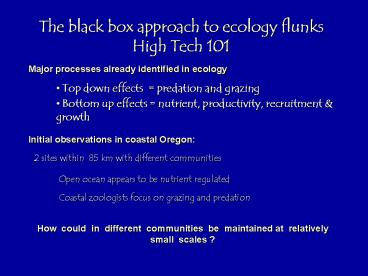
The black box approach to ecology flunks High
Tech 101
Major processes already identified in ecology
- Top down effects predation and grazing
- Bottom up effects nutrient, productivity,
recruitment growth
Initial observations in coastal Oregon
2 sites within 85 km with different communities
Open ocean appears to be nutrient regulated
Coastal zoologists focus on grazing and predation
How could in different communities be
maintained at relatively small scales ?
2
Boiler Bay Strawberry Hill abundant
macrophytes abundant filter feeders few
filter feeders, abundant macrograzers few
macrograzers, abundant predators few
predators few macrophytes
3
Strawberry Hill had higher rates of both
processes Top-down (grazing and predation)
Bottom-up processes (animal recruitment and
growth)
4
Hydrodynamic conditions do not differ between
these sites
5
Mesoscale differences arise from bottom-up
effects on pelagic phytoplankton
6
Modern Technologies
- Sea surface temperatures
- Geoplanetary Operational
- Environmental Satellite
- (GOES - 10) NOAA
http//rsd.gsfc.nasa.gov/goes/
- Chlorophyll a content on earths surface
- Sea-viewing Wide Field-of-View
- Sensor (SeaWiFS) NASA
7
GOES Satellites
Mission Life 5 years, minimum Dimensions Main
body 2 meter (7 foot) cube Deployed length
27 meters (88 feet) Weight 2100 kg (4600
lb) Orbit Geosynchronous Altitude
36,000 km (22,000 mi) Longitude 75W and
135W Latitude Equatorial, within 0.5
degree Communications Imager Sounder in
GVAR format _at_ 2.1 Mbits/sec
These satellites orbit the equatorial plane of
the Earth at a speed matching the Earth's
rotation they hover continuously over one
position on the surface. The geosynchronous plane
is about 35,800 km above the Earth, high enough
to see a full-disc view of the Earth.
8
GOES Satellites - Constant vigil for the
atmospheric "triggers
- Severe weather conditions monitored tornadoes,
flash floods and hurricanes. - monitor storm development track movements
- estimate rainfall during heavy storms for flash
flood warnings - estimate snowfall extent
- early detection of winter storms spring snow
melt advisories. - detect ice fields map the movements of sea and
lake ice - calculate sea surfaces temperatures.
9
GOES Satellites
- The GOES I-M
- Imager
- 5 channels (one visible, 4 infrared)
- imaging radiometer
- senses radiant and solar reflected energy from
sampled areas of the earths surface.
By means of a servo driven, 2-axis gimbaled
mirror scanning system in conjunction with a
Cassegrain telescope, the Imager's multispectral
channels can simultaneously sweep an 8-km (5
statute mile) N-to-S swath along an E-to-W /
W-to-E path, at a rate of 20 º (optical) E-W / s.
10
Channel 1 (Vis) 2 (Shrtwv) 3
(H2O) 4 (IR 1) 5 (IR 2)Wavelengthrange
(um) 0.55 - 0.75 3.8 - 4.0 6.5 -
7.0 10.2-11.2 11.5-InstantaneousGeograp
hic 1 km 4 km 8 km 4 km 4 km
Field of View(IGFOV) _at_ nadir
GOES Satellites
This translates into being able to scan a 3000
by 3000 km "box" centered over the United States
in just 41 seconds. The actual scanning sequence
takes places by sweeping in an E-W direction,
stepping in the N-S direction, than sweeping back
in a W-E direction, stepping N-S, sweeping E-W,
etc.
11
Modern Technologies
- Sea surface temperatures
- Geoplanetary Operational
- Environmental Satellite
- (GOES - 10) NOAA
- Chlorophyll a content on earths surface
- Sea-viewing Wide Field-of-View
- Sensor (SeaWiFS) NASA
http//seawifs.gsfc.nasa.gov/
12
SeaWiFS
- At 705 km above the earth, this satellite runs a
noon, sun-synchronous orbit, performing lunar and
solar calibration maneuvers, and providing
attitude knowledge within 1 SeaWiFS pixel.
Sensors include redundant sun sensors, horizon
sensors, and magnetometers.
Sensors evaluate 8 bands or spectral regions.
Passes take in about 1,000 x 1,000 km data sets
(1 pixel ? 1 km) in about 1 minute (1 M pixels),
about 10 years worth of research vessel time.
http//daac.gsfc.nasa.gov/CAMPAIGN_DOCS/OCDST/cla
ssic_scenes/00_classics_index.html
13
SeaWiFS
- Sensors
- Band Wavelength
- 1 402-422 nm
- 2 433-453 nm
- 3 480-500 nm
- 4 500-520 nm
- 5 545-565 nm
- 6 660-680 nm
- 7 745-785 nm
- 8 845-885 nm
- Mission Characteristics Above movie built from
1000 km w x 1000 km high or 10 6 measuremments - Orbit Type Sun Synchronous at 705 km Orbital
Period 99 minutes 14x/d - Equator Crossing Noon 20 min descending
Swath Width 2801 km - Spatial Resolution 1.1 km LAC Revisit
Time 1 day
14
SeaWiFS - getting the data BACK is the challenge
- The satellite orbits the Earth 14 times per
day, but half of the Earth is dark at any given
moment.
- SeaWiFS is only able to collect useful
information where the sun is shining, - only
during daylit portions of the orbit.
- As the satellite comes over the North Pole, the
SeaWiFS instrument is turned on and begins to
beam down data via a radio transmitter to any
receiving station that is within range.
- After about 7 orbits, the satellite passes over
the East Coast - at about noon, where it transmits half a world of
data to NASA/ - Goddard and backup stations.
15
Satellites 101
http//liftoff.msfc.nasa.gov
- Did you know there are gt 8,000 artificial
objects orbiting Earth? - Over 2,500 are satellites - operative and
inoperative. - The rest is orbital debris nosecone shrouds,
lens, hatch covers, rocket bodies, payloads that
have disin-tegrated, and even objects that
"escaped" from manned spacecraft during
operations.
http//liftoff.msfc.nasa.gov/RealTime/JTrack/3D/JT
rack3D.html
16
Satellites overhead
What can we learn?
- Buoys in 5,300 m water
17
Open ocean off Big Island - Kau side
- Trade winds blow 300 d/yr
- Peak gusts can average over 60 knots
http//www.ndbc.noaa. gov/Maps/Hawaii.shtml
18
Alenuihaha Channel
- Protected somewhat by North Kohala
- Peak gusts, on average, lt 50 knots
19
Tradewinds result in deep ocean hurricanes -
- Trades blow extended periods
- Islands deform ocean water flow
- Thermocline position changes with this
deformation
Illustration P. Flament
20
Deep water near shore for many leeward coasts
21
Cyclonic eddies spin up deep water to surface
- 50 to 200 km diam
- persist several weeks to months
mid May 1999 - Jan 2000
Loretta
3x Chl a concentration within ring vs ocean
Ku Lama Geophysical Research Letters
http//coastwatch.nmfs.hawaii.edu
22
http//coastwatch.nmfs.hawaii.edu/
More recent eddy cycle
23
(No Transcript)
24
(No Transcript)
25
(No Transcript)
26
(No Transcript)
27
(No Transcript)
28
(No Transcript)
29
(No Transcript)
30
(No Transcript)
31
(No Transcript)
32
(No Transcript)
33
(No Transcript)
34
(No Transcript)
35
(No Transcript)
36
(No Transcript)
37
(No Transcript)
38
(No Transcript)
39
(No Transcript)
40
(No Transcript)
41
(No Transcript)
42
(No Transcript)
43
(No Transcript)
44
(No Transcript)
45
(No Transcript)
46
Coccolithophorids as primary producers?
Emiliana huxleyi
Coccoliths as CaCO3 body scales
47
Nutrients arent just from the water column,
sediments or groundwater any more
48
(No Transcript)
Recommended
CrystalGraphics Presentations


