
MidAtlantic RESAC Summary of Year1 Activities - PowerPoint PPT Presentation
1 / 104
Title: MidAtlantic RESAC Summary of Year1 Activities
1
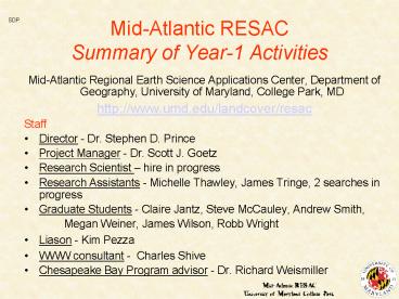
Mid-Atlantic RESACSummary of Year-1 Activities
SDP
- Mid-Atlantic Regional Earth Science Applications
Center, Department of Geography, University of
Maryland, College Park, MD - http//www.umd.edu/landcover/resac
- Staff
- Director - Dr. Stephen D. Prince
- Project Manager - Dr. Scott J. Goetz
- Research Scientist hire in progress
- Research Assistants - Michelle Thawley, James
Tringe, 2 searches in progress - Graduate Students - Claire Jantz, Steve McCauley,
Andrew Smith, - Megan Weiner, James Wilson, Robb Wright
- Liason - Kim Pezza
- WWW consultant - Charles Shive
- Chesapeake Bay Program advisor - Dr. Richard
Weismiller
2
Mid-Atlantic RESAC Outline of Presentation
- Overview
- Land Cover / Use Mapping, Modeling, Planning
- Recent mapping with Landsat
- Historical reconstruction (recent, more distance
past) - Predictive modeling (econometric, scenario
development) - Chemical / sediment transport modeling
- Riparian buffers
- Impervious surface mapping
- Hyperspectral / hyperspatial image data /
applications - Wetlands
- 99 Drought / Flood
- Bird diversity / forest framentation
- Future plans, directions, strategy
3
Mid-Atlantic RESACObjectives
- Purpose
- Provide/stimulate the use of land cover data
and modeling capabilities to a broad user
community within the mid-Atlantic region. - Cross-cutting theme
- Integrated land cover mapping - ecosystem
modeling - land use change detection - monitoring
and modeling. - Special attention to extensive human alteration
of landscapes in the CB watershed.
4
Concept of the Mid-Atlantic RESAC
- A consortium...
- focus groups, exchange of personnel, research
collaborations - Facilitate new types of interaction between
partners - e.g. MD Office of Planning - AREC - SERC,
nutrient runoff modeling - Span the gulf between research applications
- Seek scientifically feasible, practical
applications that have identified users - Leverage additional research
- e.g., UMD RS Center of Excellence, Smithsonian
SERC, UM Center for Environmental Studies, USDA
5
Applications must be Valid, Needed, Practical
Scientifically technically Valid
Valid Y Needed Y Practical N
Valid N Needed Y Practical Y
Practical application - can technique be
applied?
Needed - nature value of market
Valid Y Needed Y Practical Y
Valid N Needed Y Practical Y
6
More Concepts
- Hand off applications of new techniques
- to government or commercial production facilities
- Data/product distribution
- through NASA/UMD Earth Science Information
Partnership (ESIP) - Provide land cover modeling tools
- to a wide community (including the public)
7
Mid-Atlantic RESAC Projected Outcomes
- Improved Land Use Mapping/Modeling/Planning
- Historical reconstruction
- Recent and current land cover
- multiple resolutions
- multiple themes
- Predictive modeling
- Counties, States
- Sprawl, Smart Growth Initiatives
- Improved Ecosystem Process Modeling
- Nutrient sediment runoff
- Productivity
- Crops, forests, pasture, entire landscapes
(carbon balance) - Climate / land-surface interaction
8
Mid-Atlantic RESAC Projected Outcomes 2
- Improved Land Management
- Riparian buffers
- Wetlands
- Crop condition information forecasting
- Decision support information
- Integrated Assessment
- Coordinated modeling monitoring
- Ecosystem services valuation
9
Mid-Atlantic RESAC Results thus far
SJG
- Land Cover / Use Mapping, Modeling, Planning
- Recent mapping with Landsat
- Historical reconstruction
- Recent past (Landsat era)
- Distant past (multiple sources)
- Predictive modeling
10
Land Cover Mapping with Landsat Imagery
- Utilize Landsat-7 imagery for..
- Classification of the mid-Atlantic region.
- Rapid field assessment.
- Assess the panchromatic band for field location,
feature delineation. - Assess information content of multi-temporal
image data sets resulting classification
accuracies.
11
1999 Field Work
12
Data Collection using GIS, Laptops, GPS
13
Landsat and Merge Comparison
Landsat 7 image
Landsat/SPOT merge
14
Landsat and SPOT Panchromatic Bands
Landsat 7 panchromatic .52m to .90m
SPOT panchromatic .51m to .73m
15
Landsat and SPOT Resolution Merges
Landsat/Landsat merge
Landsat/SPOT merge
16
Field SurveySites Summer, 1999
17
1999 Field Data
18
Landsat TM Image Statistics
- Total Landsat Inventory
- 71 scenes in house
- EarthSat Geocover (20 orthorectified scenes)
- 32 Landsat-5 historical courtesy of Landsat
Science Team - 13 Landsat-5 multi-temporal 98 (15-32/15-34)
- MRLC database (40 scenes)
- Landsat 5 TM
- 14 in house (6 are 98 scenes used for multi-temp
analyses) - Landsat 7 ETM
- 54 scenes in house (5 georectified)
- Best imagery from July through Sept 99
- All scenes for 2000 being acquired
19
Decision Tree Classification
20
Multi-temporal Land Cover Classification
Subset of Washington, D.C. Metro Area
21
Accuracy of Multi-temporal TM Classification
22
Classification Comparison
MRLC
RESAC
23
Beltsville Agricultural Research CenterField
Boundaries with Crop Information
24
TM Crop Profiles at BARC
25
Comparison Between Corn and Soybeans at BARC
NDVI 1 July 98
26
Highlights of Landsat TM Mapping
- Landsat7 ETM imagery high quality.
- Rapid transfer of imagery increases value of
field work. - Phenological studies.
- Reduced cost encourages use of multi-temporal
data. - Panchromatic band an important addition - future
improvements could make it even better. - Use of multi-temporal imagery improves
classification accuracy, particularly crops from
grasslands.
27
Planning and Land Use Change
- Past land use change..
- Recent history (27-yr Landsat record)
- Patterns of residential development
- Relations to regulatory management
- Historical reconstruction (back to 18th century)
- Variety of data sources..
- Imagery to 1970s
- Aerial photos to 1940s
- Maps, agricultural census, records, etcbeyond
28
Historical Land Cover Change AnalysisMontgomery
County, MD and Fairfax County, VA
- Purpose
- To create a historic land cover data set for the
Washington Metropolitan Region, and link with
land use management decisions. - Methodology
- Manual classification of historical air photos
for selected sample sites within the region - Regional analysis using satellite derived land
cover.
29
Location of Sites for Historic Land Cover Change
Analysis
30
Historic Land Cover Change around Olney in
Montgomery Co, MD
1951
1998
31
Fragmentation Analysis of two Counties using
Satellite Forest Cover maps
- Analyzing patterns of forest fragmentation in
Montgomery County, MD and Fairfax County, VA - Relating patterns to land use history,
environmental, and policy factors. - Methods
- Calculate landscape / forest fragmentation and
derive related metrics (using FragStats software)
32
All forest classes combined Fairfax Mont Co.
33
Analysis of Growth Patterns in Montgomery and
Fairfax counties
- Purpose
- Does smart growth policy conserve rural / open
space? - Methods
- Analyses of recent urban growth, mapped with
Landsat imagery, for 3 decades (70s, 80s, 90s) - Comparison with distance from Metro (mass
transit) stations.
34
Development in the Washington, D.C. Area 1973-1996
35
Rates of Development
- Square kilometers of development per year in
Montgomery and Fairfax counties
36
Distance of New Development from the Nearest
Metro Station, 1973-1985
- Montgomery County tended to develop closer to
Metro stops. - Over 40 of new development in Montgomery County
was within 8 km of a Metro station.
37
Distance of New Development from the Nearest
Metro Station, 1985-1990
- Almost 50 of new development in Montgomery
County was within 8 km of a Metro station. - Over 40 of new development in Fairfax County
occurred between 13-18 km.
38
Distance of New Development from the Nearest
Metro Station, 1990-1996
- Patterns were similar between the two counties.
- Most new development in both counties occurred
between 8-13 km from a Metro station.
39
Distance of Maximum Development from the Nearest
Metro Station
40
Recent Growth Comparisons
- Montgomery County developed closer to Metro
stops sprawl constrained to a certain extent. - Development trends can be linked to differences
in regulatory policies - history and environmental factors also play
important roles.
41
Historical Land Use ChangeShenandoah Valley, VA
- Goals
- Reconstruct and visualize historic land use
change in the Valley (11,000 sq km). - Agriculture vs forest extent
- Link changes to water quality measurements.
- Consider implications for carbon fluxes, making
use of extensive FIA data. - Initially 1950-2000, later 1850, possibly 1700
42
Shenandoah Valley Region
Md.
- Shenandoah River Valley
- 7 counties in Va
- 1 county in W. Va.
- Broader Region
- 1 county in Va.
- 1 county in W. Va.
- Initial analyses. focused on 8 counties in
Virginia
W.Va.
Frederick
Shenandoah
Shenandoah River Watershed
Clarke
Warren
Page
Rockingham
Augusta
Va.
Rockbridge
43
Virginia Counties
44
Virginia Counties
45
Data Sources
Satellites
Aerial Photography
DEMs
Soils
Topographic Maps
Cultural Features
Hydrography
Phenomenon of Interest
Topography
C o n t e n t
I n t e r v a l
E x t e n t
S c a l e
Woodlands
Census
County Aggregates
Individual Returns
Cadastre
Unique Atlases Maps
Landscape Paintings Photographs
Textual Descriptions and Data of Landscape and
Activities
jww
2000
-gt1700
TIME
46
USGS 15 Minute Maps
- All maps were produced via field mapping
techniques - Green - indicates date of publication.
- Red - maps compiled from aerial photography.
- Sample imagery compiled from aerial photography
will be analyzed to verify woodland
interpretation on maps.
47
Planning and Future Land Use Change
- Spatial predictive models
- Economic micro-decision models
- Maryland property view - parcel level
- Impact scenarios
- Include economic valuation
- Make available through WWW
48
Predicting Future Land Use Change with a
Spatial econometric model
49
Simulated land use reallocation including
influence of road networks
Maryland counties in Washington DC ( Baltimore)
Metro region
50
Simulated land use change including roads and
zoning
51
(No Transcript)
52
(No Transcript)
53
Land Use Change Scenario Development with
CITYgreen
54
CITYgreen Tree Growth
20 Years
Current
C storage NPP Runoff Red. Storage Vol.
86 1.95 25 15,974
165 tons 0.3 tons/yr 33 22,451 ft3
55
Transport Modeling
- Land cover / use a key component to chemical and
sediment transport - Impervious surface area
- Buffers and other filters
- Landscape configuration
- Nutrient runoff analysed in this context
- Collaboration with SERC, AL, others..
56
SERC Model summary
57
SERC Land Use-Hydrology Model
Term Variance Crop 51 BFI 69 CropXBFI 85 Pr
ovince 89
R2.93
58
Nitrate vs. Land Cover
59
Riparian Forest
60
Riparian Forest Cross Section
61
Nitrate in Riparian Forest Groundwater
62
Transport Modeling - Status
- An analysis of SERC model with land use ongoing
- Critical need for improved land cover / use maps
- Accuracy assessment planned for small, gauged
catchments - SERC has contributed funds for a Research
Scientist - Workshop planned to discuss these activities with
broad science / user community
63
Impervious Surface Mapping
- Area of impervious surface within a watershed has
important implications for water quality - Recent evidence for alteration of local weather
- Quatrocchi
- Important for monitoring urban sprawl
- Remote sensing techniques need to be improved
64
Montgomery County, MD
Landsat 5 TM 3/27/98
R Band 4 G Band 5 B Band 3
65
Montgomery County, MD
NDVI Composite Leaf-on and Leaf-off
R NDVI 4/28/98 G NDVI 3/27/98 B NDVI 3/27/98
66
(No Transcript)
67
Montgomery County, MD
Landsat 5 TM 3/27/98 Soil vs. Impervious
Band1Band5 Ratio
Low High
68
Montgomery County GIS
Vector Layers
Impervious Surfaces
69
GIS Scaled from 3 to 30 meters
Simulated 30m Percent Imperviousness
Vector Layers Gridded to 3m
70
Montgomery County, MD
Simulated TM Scale Impervious Surfaces from GIS
Layers
Estimated Percent Imperviousness
0 10 20 30 40 50 60 70 80
90 100
71
KT Greenness with GIS Impervious Surface Layer
72
Impervious Surface Mapping
- Next steps..
- Document utility of various indices used thus far
- NDVI, KT Greenness, Landsat ch. 5/1 ratio, etc.
- Use GIS for validation
- Explore use of high resolution (ADAR, IKONOS) and
hyperspectral imagery(AISA) - Collaborations with Nautilus RESAC / NEMO, others
- Assess validity of basin-wide products
73
Hyperspectral Imagery
- Hyperspectral imagery is being assessed in
Montgomery Co MD for - Impervious surface type discrimination
- Forest type mapping for resource inventories
- Multi-scale, multi-spectral analyses compared to
ADAR IKONOS (similar spatial res), and ETM
74
Airborne Imaging Spectroradiometer for
Applications (AISA)
Rock Creek Regional Park, Mont. Co, MD
AISA TM
75
AISA Imagery Acquired on October 27, 1999
R (669.02-675.78 nm) G (549.32-555.80 nm) B
(458.54-465.02 nm)
76
AISA Spectral CapabilitiesWheaton Regional Park,
Maryland
77
Spectral Analysis of AISAfor Impervious Surfaces
Delineation
78
More Demonstration Projects
- Riparian buffer mapping
- Wetlands mapping
- Drought / flood / crop monitoring
- Biological resources
- High spatial resolution imagery critical for some
applications - ADAR
- IKONOS
- IFSAR
79
ADAR 5500 Imagery
- Acquired by Positive Systems
- Airborne digital camera (Kodak DCS 420-IR)
- High resolution
- .8 meter pixel size
- 4 spectral bands
- 3 in visible range
- 1 in near infrared
- Same spectral bands as Landsat TM bands 1-4
- Each frame is 900 by 1300 meters
- Imagery acquired in October, 1999
80
ADAR Frame Centers
- 4700 Frames
- 25 GB data
81
Mosaic of 3 ADAR Frames
82
Area of 3 ADAR frames with Landsat
83
ADAR Detail in Color Infrared
84
STAR-3i Imagery
- Airborne radar sensor utilizes return from 2
simultaneous X-band signals to create a stereo
view of the landscape - Acquired in June, 1999
- Collaboration with UMBC provides complete
coverage from DC to Baltimore - Primary product 10 meter resolution DEM
- Secondary product 2.5 meter radar backscatter
image
85
STAR-3i Acquisition
DEM
Backscatter
86
STAR-3i Backscatter Image
- DEM
- X-band based RADAR product penetrates canopy
little - provides canopy top DEM
- Brighter areas are forest, darker areas are flat
agricultural lands. - Backscatter Image
- Provides 2.5 meter precision orthocorrected base
map - Brighter areas are coarse surfaces, darker areas
flat
87
STAR-3i DEM Product - detail
88
ADAR draped over IFSAR DEMLittle Falls of
Potomac, DC
89
Wetlands
- Wetlands in the Chesapeake Bay watershed
- Crucial functions such as..
- maintenance of water quality, habitat, etc
- ..but extensively modified
- Drained for agriculture development
- even in protected areas (BNWR) through changes
in drainage - Sea level rise exacerbates flooding erosion
90
Wetlands
- Objective
- Assess the potential for improved
characterization delineation of wetlands,
partic. forested wetlands - Methods
- Review current past activities
- Multi-temporal SAR and Landsat imagery with
extensive field data - ASF data only proposal submitted through
NASA/ADRO2
91
Historical Coastal Marsh Deterioration
Blackwater National Wildlife Refuge,
Maryland 1938 - 1993
1938 Aerial Photos
1989 Landsat TM
1993 Landsat TM
92
Wetland Study Sites
93
Wetlands
94
Wetlands SAR Image Data Availability
95
Forested WetlandsMappingwith RADAR
- Radar double- bounce effect
- Particularly useful in flooded forests
96
Mid-Atlantic Drought of 1999
- Worst drought in recorded history in Summer of
1999. - Following the drought Hurricane Floyd caused
extensive flooding. - These events were monitored using satellite
imagery - see 18-April-2000 AGU EOS Transactions article
97
Change in Landsat NDVI fromJuly 14, 1997 to July
28, 1999
98
Drought MonitoringChange inAVHRR
NDVIfromJuly, 1995 toJuly, 1999
99
Sediment plumeafter hurricane Floydobserved
with AVHRR
100
Biological Resource Issues
- Bird species richness analysed with respect to..
- forest fragmentation indices
- number, area, density and distribution of forest
patches - Breeding bird survey (BBS) observations for MD
- Available for a 25 year period
- provide a unique data set for testing the effects
of habitat fragmentation. - Collaboration with Patuxent National Wildlife
Center, USGS BRD
101
Forest fragmentation is depicted here by the
number of core areas, i.e., patches of forest
that are relatively insulated from edge effects.
102
Mean bird species richness for each BBS route in
Maryland. At fine scales (about 1 km), 40 of
the variation in species richness is explained
by the variation in the number of core areas.
For many bird species, edge effects, such as
increased brood parasitism, are detrimental
103
Mid-Atlantic RESAC Business Plan
- Green, red, blue boxes indicate composition of
RESAC round table meetings
RESAC Round table
EXPERTS RESAC Science Research Industry,Government
USERS Assessments Products Techniques
RESEARCH RESAC Partners
104
Mid-Atlantic RESAC Organization
Science contacts
Outreach
Fundamental Research RESAC Partners Others
End Users
Applications Research RESAC Partners Others
focused meetings, www, press releases, Co-Op
Extension Serv.
e.g. AAG session USDA-BARC NWI/Md DNR
Recommended
CrystalGraphics Presentations


