
US AIRSPACE - PowerPoint PPT Presentation
1 / 100
Title: US AIRSPACE
1
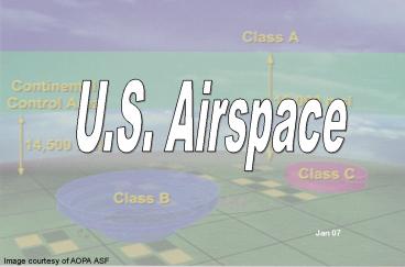
U.S. Airspace
Jan 07
Image courtesy of AOPA ASF
2
(No Transcript)
3
Airspace.Who Cares??
- CSAF Message, Mar 2001
- TO ENSURE COMPLETE UNDERSTANDING OF THE NAS
- ....REVIEW AND REVISE AS REQUIRED IRC COURSE
MATERIAL TO ENSURE A COMPLETE UNDERSTANDING OF
THE NAS BY ALL AF PILOTS AND NAVIGATORS
4
(No Transcript)
5
OBJECTIVES
- Identify the characteristics of controlled
airspace - Differentiate between classes of airspace the
ATC services provided in each - Differentiate between the types of Special Use
Airspace
6
OVERVIEW
- CONTROLLED AIRSPACE
- UNCONTROLLED AIRSPACE
- SECTIONAL EXERCISE!
- SPECIAL USE AIRSPACE
- (TFR/ADIZ BRIEF)
7
CONTROLLED AIRSPACE
- AIRSPACE WHERE AIR TRAFFIC CONTROL SERVICE IS
PROVIDED TO IFR FLIGHTS... - AND MAYBE TO VFR FLIGHTS
(CHECK THE AIRSPACE CLASSIFICATION.) - Not limited by radar coverage (ex. NATS)
8
1993 FAA adopted ICAO classifications
9
Class A Airspace
10
(No Transcript)
11
CLASS A AIRSPACE
- From 18,000 MSL up to and including FL 600
- Jet Routes/ RNAV Routes from FL180 to FL450
- Includes the airspace within 12 nautical miles
off the coast of the 48 contiguous States and
Alaska - Plus, designated international airspace beyond 12
nautical miles off the coast, within which
domestic procedures are applied
12
CLASS A RESTRICTIONS
- IFR FLIGHT PLAN
- ATC CLEARANCE
- 2-WAY RADIO TRANSPONDER
- DME (AT OR ABOVE FL240) if VOR req
13
High Altitude RNAV Routes effective May 2003
- Prefaced by the letter Q e.g. Q9
- RNAV route data (route line, id boxes, mileages,
waypoints) are printed in aeronautical blue.
Magnetic reference bearings will be shown
originating from a waypoint, fix, or NAVAID. - DME/DME INU or GPS required
14
High Altitude RNAV Routes
Note Currently Radar monitoring is required
on Q Routes. So if the ARTCC radar is out, the
routes will not be assigned nor flown.
15
Class B Airspace
16
(No Transcript)
17
CLASS B AIRSPACE FROM THE SURFACE TO 10,000 FEET
MSL (there are exceptions!) SURROUNDING THE
NATION'S BUSIEST AIRPORTS (ref AIM
3-2-3a) (Lateral dimensions vary from airport to
airport, usually 20-30nm wide)
18
CLASS B RESTRICTIONS
- ATC CLEARANCE
- 2-WAY RADIO TRANSPONDER
- FOR IFR, A VOR OR TACAN RECEIVER
- PRIVATE PILOT CERTIFICATE (SOME EXCEPTIONS
Reference AIM 3-2-3 b2) - SPEED RESTRICTION
- 200 KNOTS BELOW CLASS B
19
CLASS B RESTRICTIONS
- AIM Chap 3-2-3
- Unless otherwise authorized by ATC, each person
operating a large turbine engine-powered airplane
to or from a primary airport shall operate at or
above the designated floors while within the
lateral limits of Class B airspace. - (includes clearance for visual approach)
20
Aeromexico DC-9 flight 498 / Piper N4891F
August 31 1986
21
(No Transcript)
22
CONCLUSION / RECOMMENDATIONS
- BOTH AIRCRAFT UNDER SEE AND AVOID
- PIPER AIRCRAFT ENTERED TCA WITHOUT CLEARANCE
- CONTROLLER DID NOT SEE PIPER AIRCRAFT ON RADAR,
THEREFORE, DID NOT ISSUE SAFETY ADVISORY - L A DID NOT HAVE AUTOMATIC CONFLICT ALERT
- EXPEDITE TCAS DEVELOPMENT AND OPERATIONAL
EVALUATION AND REQUIRE IT IN PART 121 AND 135 - REQUIRE MODE C IN ARSAs
- EXPEDITE CONFLICT ALERT IN ART IIIA SYSTEMS
- ACCELERATE PROGRAM TO PROVIDE SEPARATION BETWEEN
HIGH AND LOW PERFORMANCE AIRCRAFT IN BUSY AREAS - REQUIRE GENERAL AVIATION AIRCRAFT TO USE ALL
AVAILABLE LIGHTING EQUIPMENT AROUND HIGH-DENSITY
AREAS
23
THE MODE C VEIL
- Within 30 NM of the primary airport of Class B
- Below 10,000 feet MSL
- Above 10,000 always required
TRANSPONDER WITH MODE C IS REQUIRED
24
ATC SEPARATION
- B only Class where VFR is separated from VFR as
well as IFR traffic - MORE THAN 19,000 LBS OR TURBOJETS
- 1.5 NM LATERAL SEPARATION, or
- 500 FEET VERTICAL SEPARATION, or
- VISUAL SEPARATION
- LESS THAN 19,000 LBS
- TARGET RESOLUTION, or
- 500 FEET VERTICAL SEPARATION, or
- VISUAL SEPARATION
- VFR still responsible for cloud clearances
25
(No Transcript)
26
(No Transcript)
27
Class C Airspace
28
(No Transcript)
29
CLASS C AIRSPACE
operational control tower
- Generally, that airspace from the surface to
4,000 feet above the airport elevation (charted
in MSL) surrounding those airports that have an
operational control tower, are serviced by a
radar approach control, and that have a certain
number of IFR operations or passenger
enplanements. Although the configuration of each
Class C airspace area is individually tailored,
the airspace usually consists of a 5 NM radius
core surface area that extends from the surface
up to 4,000 feet above the airport elevation, and
a 10 NM radius shelf area that extends from 1,200
feet to 4,000 feet above the airport elevation.
radar approach control
that have a certain number of IFR operations or
passenger enplanements
30
4000 Above Airport Elevation
Class C Airspace
No Lower Than 1200 Above Airport Elevation
SURFACE
31
10 nm
5 nm
- COMPLY WITH FAA DEPARTURE PROCEDURES
- 2-WAY RADIO COMMUNICATIONS
- TRANSPONDER with mode C up to 10,000 MSL
- 200 kts at/below 2500 AAE w/in 4 NM of airport
- (AIM 3-2-4)
32
2-WAY RADIO COMMUNICATIONSDEFINITION
- If the controller responds to a radio call with,
"(aircraft call sign) standby," radio
communications have been established and the
pilot can enter the Class C airspace. - If workload or traffic conditions prevent
immediate provision of Class C services, the
controller will inform the pilot to remain
outside the Class C airspace until conditions
permit the services to be provided. - It is important to understand that if the
controller responds to the initial radio call
WITHOUT using the aircraft identification, radio
communications have not been established and the
pilot may not enter the Class C airspace.
33
(No Transcript)
34
(No Transcript)
35
UPPER LIMIT OF RAPCON AIRSPACE
20 NM
LOWER LIMIT OF RADAR COVERAGE
36
THE OUTER AREA
- CLASS C SERVICES ARE PROVIDED ON A VOLUNTARY
BASIS - 20 NM UNCHARTED RING AROUND THE AIRPORT
- FROM MINIMUM RADAR ALTITUDE TO CEILING OF THE
RAPCONS AIRSPACE
37
ATC SEPARATION
- Separation is provided within the Class C
airspace and the Outer Area after two-way radio
communications and radar contact are established.
VFR aircraft are separated from IFR aircraft by
any of the following - 1. Visual separation.
- 2. 500 feet vertical, except when operating
beneath a heavy jet. - 3. Target resolution.
38
Class D Airspace
39
(No Transcript)
40
AIRSPACE FROM THE SURFACE TO 2,500 FEET ABOVE THE
AIRPORT ELEVATION (CHARTED IN MSL) SURROUNDING
THOSE AIRPORTS THAT HAVE AN OPERATIONAL CONTROL
TOWER. Size Varies, Tailored IAP
41
CLASS D RESTRICTIONS
- COMPLY WITH FAA DEPT PROCEDURES
- 2-WAY RADIO COMMUNICATION
- 200 KNOT MAX w/i 4nm at or below 2500MSL
- Large or Tubine Powered A/C (FAR 91.129)
- 1500 AGL pattern
- ILS equipped at or above GS OM to MM, VASI
- NO SEPARATION FOR VFR
42
(No Transcript)
43
Class E Airspace
44
(No Transcript)
45
Image courtesy of AOPA ASF
- CLASS E AIRSPACE GENERALLY BEGINS AT THE TOP OF
CLASS G AIRSPACE - 14,500 MSL is standard (up to not including
18,000 MSL, above FL600) - Surface, 700 AGL OR 1200 AGL for instrument
transitions - Federal Airways generally starts at 1200 AGL
- - At various altitudes over the mountains
46
CLASS E may go to the surface in some locations
47
Class E Airspace
48
Class ERestrictions/Services
- CLOUD CLEARANCE
- Below 10,000 MSL - 3 SM 500-1000-2000
- At and above 10,000 - 5 SM 1000-1000-1 SM
- AIRSPEEDS
- 250 KIAS BELOW 10,000
- FEDERAL AIRWAYS
- No VFR flight along airways (AF restriction)
- ATC SERVICES
- No separation services provided to VFR traffic
- Talk to tower within 4NM below 2500 AGL
49
VICTOR ROUTES
- 1200 UP TO BUT NOT INCLUDING 18,000 MSL
- DEPICTED ON EN ROUTE LOW CHARTS
- BASED ON VOR OR TACAN (some NDB)
- HAVE A SPECIFIC WIDTH
50
CLASS F AIRSPACE?!
- UNCONTROLLED WITH REPORTING POINTS
- PROVIDES SEPARATION BETWEEN IFR AIRCRAFT AS FAR
AS PRACTICAL - NOT USED IN THE UNITED STATES
51
- CLASS G AIRSPACE
52
(No Transcript)
53
(No Transcript)
54
IFR in Class G Airspace?
- Yes! (But not wise)
- Not required to file a flight plan, but must
adhere to FAR Part 91 - Totally responsible for own traffic
separation/obstacle clearance - Pilots operating IFR in uncontrolled airspace
shall maintain altitude IAW the diagram published
on the appropriate en route chart. - 11-202v3,
para 8.9.2. - Must remain at least 1000 (2000 designated
mountainous) above highest obstacle within 5 nm
of course flown - AFI 11-202v3, para 8.8.2.1.3.
55
Designated Mountainous?
- Mountainous terrain is designated by FAR 95.11
and AIM 5-64 - When operating outside US domestic airspace any
terrain above 3000 ft will be considered
mountainous terrain
AFI 11-202v3
56
(No Transcript)
57
Tower in Class G?
- Comm required by 4NM within 2500 AGL
- FAR 91.126
58
Terminal Radar Services for VFR Aircraft
- BASIC SERVICE - SAFETY ALERTS, TRAFFIC
ADVISORIES, LIMITED RADAR VECTORING WHEN
REQUESTED, AND SEQUENCING WHERE PROCEDURES
ESTABLISHED - TERMINAL RADAR SERVICE AREA (TRSA) - BASIC,
SEQUENCING OF ALL IFR AND PARTICIPATING VFR
TRAFFIC AND SEPARATION OF ALL PARTICIPATING VFR
AND ALL IFR IN THE AREA - CLASS C SERVICE - BASIC, APPROVED SEPARATION
BETWEEN IFR AND VFR AIRCRAFT AND SEQUENCING OF
VFR ARRIVALS TO THE PRIMARY AIRPORT - CLASS B SERVICE - BASIC, APPROVED SEPARATION OF
AIRCRAFT BASED ON IFR, VFR, AND/OR WEIGHT AND
SEQUENCING OF VFR ARRIVALS AT THE PRIMARY AIRPORT
59
OTHER AIRSPACE WHATS A TRSA?(TERMINAL RADAR
SERVICE AREA)
- The 1993 Airspace reclassification intended to
classify all of the old ARSA and TRSA areas
as Class C or B airspace. - A TRSA is airspace that does not fit the
requirements of Class C airspace but is too busy
to be just Class D airspace. Technically, a TRSA
is an "other type" of airspace rather than a type
of controlled airspace
60
AIM 4-1-17 b.1 The purpose of this service is to
provide separation between all participating VFR
aircraft and all IFR aircraft operating within
the airspace defined as the Terminal Radar
Service Area (TRSA)
61
SEPARATION SUMMARY
- CLASS A
- No VFR allowed
- CLASS B
- VFR are separated from IFR and VFR
- CLASS C
- VFR are separated from IFR
- CLASS D
- No separation for VFR
- CLASS E
- No separation for VFR (ATC provided for IFR)
62
Transponder Requirements (with Mode C)
- All aircraft in all airspace above the ceiling
and within the lateral limits of Class B or Class
C airspace up to 10,000 MSL - In all 48 Contiguous states and District of
Columbia at and above 10,000 MSL, excluding
below 2500 AGL
63
USAF VFR CLOUD CLEARANCE AND VISIBILITY MINIMUMS
64
SECTIONAL EXERCISE!
After A BREAK!!
65
NACO 1500,000 Mode C Veil Altitudes MEF Whit
e Line
66
Denver Terminal Area Chart
- BLOWN UP SECTIONAL
- AIRWAYS, ALTITUDES, AIRSPACE, FREQS
- PLANNING CHART ON BACK
- LEGEND, FLYWAY, REPORTING POINTS
67
VFR Routes
- VFR Flyway
- general flight path for planning flights through
or around complex airspace - Class B VFR Transition Route
- Specific route/alt through Class B
- Requires Clearance and Comm in/out Class B
- VFR Corridor
- Tunnel through Class B
- No Clearance or Comm Required
68
(No Transcript)
69
VFR out of JEFFCO Southbound Airspace? Class E
Alt Route/ Alt 8500 Flyway
70
(No Transcript)
71
SFC to 14,500 Class G 14,500 to 18,000 Class E
Non standard
Class E 700 AGL
SFC to 1200 AGL Class G 1200 AGL to 18,000
Class E
72
SPECIAL USE AIRSPACE
- CONSISTS OF THAT AIRSPACE WHEREIN ACTIVITIES
MUST BE CONFINED BECAUSE OF THEIR NATURE, OR
WHERE LIMITS ARE IMPOSED UPON AIRCRAFT OPERATIONS.
73
ALERT AREA
- CONTAINS A HIGH VOLUME OF PILOT TRAINING
ACTIVITIES OR AN UNUSUAL TYPE OF AERIAL ACTIVITY.
74
CONTROLLED FIRING AREA
(Stealth AirspaceNOT Depicted on charts)
- AIRSPACE ACTIVITIES ARE CONDUCTED UNDER
CONDITIONS SO CONTROLLED AS TO ELIMINATE HAZARDS
TO NON-PARTICIPATION AIRCRAFT AND ENSURE SAFETY
OF PROPERTY AND PERSONS ON THE GROUND.
TIP Check the Airport/Facilities Directory in
the back under Special Notices!
75
(No Transcript)
76
MILITARY OPERATIONS AREA
- USED TO SEPARATE MILITARY ACTIVITIES
- NON-HAZARDOUS ACTIVITIES ONLY
- VFR TRAFFIC MAY TRANSIT MOAs
- DO NOT EXTEND ABOVE 18,000 MSL?
77
ATCAA(Stealth Airspace)
- AIRSPACE ASSIGNED BY ATC THROUGH LETTERS OF
AGREEMENT. AREAS ARE NORMALLY AT 18,000 MSL AND
ABOVE AND ARE USUALLY LOCATED ABOVE MOAs.
78
WARNING AREA
- AREAS ESTABLISHED IN INTERNATIONAL AIRSPACE
WHICH MAY CONTAIN ACTIVITIES HAZARDOUS TO
NON-PARTICIPATING AIRCRAFT.
79
PROHIBITED AREA
- DESIGNATED AIRSPACE WITHIN WHICH THE FLIGHT OF
AIRCRAFT IS PROHIBITED.
80
RESTRICTED AREA
- AIRSPACE DESIGNATED UNDER FAR PART 73 ( Subpart
B ) - WITHIN WHICH THE FLIGHT OF AIRCRAFT IS SUBJECT
TO RESTRICTIONS.
81
MILITARY TRAINING ROUTES
- AIRSPACE ESTABLISHED FOR THE CONDUCT OF MILITARY
FLIGHTS TRAINING AT AIRSPEEDS IN EXCESS OF 250
KIAS. THERE ARE 2 TYPES OF ROUTES IR AND VR.
82
IR/VR Routes
- MTRs are one-way routes. Opposite directions
have separate designators
- Avoid charted, uncontrolled airports by 3 NM or
1,500, when practical
- IR routes must be on a flight plan. Pilots
flying IFR to/from VR routes must file IFR flight
plan with entry/exit fixes
- PLAN THOROUGHLY PFPS, Sectionals/Low Enroute,
AP series
83
SLOW SPEED LOW ALTITUDE TRAINING ROUTES (SR)
- ROUTES WHICH ARE USED FOR MILITARY AIR
OPERATIONS AT OR BELOW 1,500 AGL AT SPEEDS OF 250
KIAS OR LESS.
Stealth AirspaceNOT on Low Enroute Chart
84
LOW ALTITUDE TACTICAL NAVIGATION AREA
(LATN)(Stealth Airspace)
- LARGE GEOGRAPHIC AREA WHERE RANDOM LOW ALTITUDE
OPERATIONS ARE CONDUCTED AT SPEEDS LESS THAN 250
KIAS.
85
AIR REFUELING AREAS(Stealth Airspace)
- NORMALLY CALLED TRACKS OR ANCHORS. THESE AREAS
ARE DESCRIBED IN FAAH 7610.4. ALL DOMESTIC
TRACKS AND ANCHORS ARE LISTED IN FLIP AP/1B.
86
Temporary Flight Restrictions (TFR) and ADIZ
Procedures Briefing
PRIMARY AFFSA HOT TOPIC Mandatory IRC Briefing
Requirement
87
Temporary Flight Restrictions (TFRs)
- Established when traffic in the airspace would
endanger or hamper air or ground activities in
the designated area - Examples
- National disasters (forest fires, floods)
- National Security Areas (President, etc.)
- Issued via NOTAMs
- NOTE TFRs change daily and sometimes hourly
- CHECK NOTAMs for Most Current Information!
88
TFR Information
- Military aircraft may or may not be excluded from
TFRs - Example TFRs Established for 2003 Southern
California Fires Excluded All Except Authorized
Firefighting Aircraft - If your mission requires flight through TFR
contact the FSS nearest the incident site. - This FSS is usually the "coordination facility"
between emergency control authorities and
affected aircraft. - ARTCC may act as liaison for emergency control
authorities if adequate communications cannot be
established between the designated FSS and the
relief organization. - AN ATC CLEARANCE IS NOT AUTHORIZATION TO ENTER A
TFR. YOU MUST BE AUTHORIZED BY THE PROPER
AUTHORITIES!!
89
ADIZ
- An Air Defense Identification Zone (ADIZ) is an
area of airspace over land or water, extending
upward from the surface, within which the ready
identification, the location, and the control of
aircraft are required in the interest of national
security.
90
Washington DC ADIZ
- ADIZ Area roughly corresponds to DC Class B
Airspace - NOT IDENTICAL
- Now published on Washington Sectional Chart and
Terminal Area Chart - Area around Camp David (Thurmont MD) and Crawford
TX are also Included - Both expand by NOTAM when President is present
- Check NOTAMs Prior to Every Flight for Most
Current Information - DIMENSIONS AND PROCEDURES DO CHANGE!
91
ADIZ and Flight Restricted Zone (FRZ)
- FRZ Approximately 15 nm Circle From DCA VORTAC
- Military, law enforcement, Medevac, Part 121 are
ONLY aircraft allowed without waiver - Check NOTAMs prior to every flight for most
current information - DIMENSIONS AND PROCEDURES DO CHANGE!
- Military operations in ADIZ and FRZ
- For IFR operations, procedures are fairly
transparent - For VFR operations, military operators are
frequent violators in this airspace
92
Operating Tips for ADIZ
- DO NOT SQUAWK 1200 IN THE ADIZ
- If ATC clears you to 1200, query the controller
- Unless complying with specific procedures do not
squawk 12_ _ in the ADIZ you must have a
discrete transponder code, even when VFR - Always File a Flight Plan, Even When VFR (DVFR)
- Always ensure you are in two-way radio
communication with ATC prior to entering the ADIZ - If your transponder fails, expect to be directed
out of the ADIZ or return for immediate landing
at your departure airport NO EXCEPTIONS
93
TFR and ADIZ Information
- The Following Web Sites Provide Information on
TFR and ADIZ Procedures and Locations - https//www.notams.jcs.mil/ (PRIMARY RESOURCE)
- http//tfr.faa.gov
94
Questions??
95
What else?
- MNPS- Minimum Navigational Perf Standard
- BRNAV- Basic RNAV
- Remote Oceanic
- AMU- Area of Mag Unreliability
- RNP-5
- RVSM
96
RESPONSE ITEM 1
- Prior to entering Class B Airspace, a VFR
aircraft must - A. Turn on the transponder with Mode C and
squawk 7600 - B. Receive ATC authorization
- C. Slow to 300 KIAS or less
- D. All of the above
B.
97
RESPONSE ITEM 2
- In Class B Airspace, the Mode C veil extends from
the primary airport to - A. 20 NM
- B. 30 NM
- C. 40 NM
- D. 100 NM
B.
98
RESPONSE ITEM 3
- Which of the following statements concerning MOAs
is false? - A. Non-participating VFR traffic requires an
ATC clearance to enter - B. MOAs terminate at 18,000 MSL
- C. MOAs include only non-hazardous activities
- D. Aircraft operating in a MOA may exceed 250
knots below 10,000 MSL
A.
99
RESPONSE ITEM 4
- Which of the following statements concerning
Class C Airspace is True? - A. Extends from surface to 4,000 AGL within 30
NM of the airport - B. Surrounds tower-controlled airports serviced
by RAPCON/TRACON - C. Radio contact is not required prior to entry
- D. VFR aircraft must file IFR prior to entry
B.
100
RESPONSE ITEM 5
- Which of the following statements concerning
Class D airspace is False? - A. Generally extends from the surface to 2,500
feet AGL - B. Surrounds airports that have an operational
control tower - C. Always extends 5 NM laterally 10,000
vertically - D. Requires two-way radio communication prior
to entry
C.
101
RESPONSE ITEM 6
- Unless designated at a lower altitude, Class E
airspace begins at _____ to, but not including
18,000 feet MSL. - A. The surface
- B. 700 feet AGL
- C. 1200 feet AGL
- D. 14,500 feet MSL
D.
102
Response Item 7
- A transponder with Mode C is required
- A. Above the ceiling and within the lateral
limits of Class B airspace up to 10,000 MSL - B. Above the ceiling and within the lateral
limits of Class C airspace up to 10,000 MSL - C. Above 10,000 MSL (excluding below 2500
AGL) in all 48 contiguous states - D. All of the above
D.
103
So How Did We Do?
- Identify the characteristics of controlled
airspace? - Differentiate between classes of airspace the
ATC services provided in each? - Differentiate between the types of Special Use
Airspace?
104
T-38 HATR
- T-38 Formation on VR Route at 700 AGL
- Civilian climbing VFR not squawking
- What type of airspace?
- What seperation rules apply?
105
Critiques
Jan 07
Image courtesy of AOPA ASF
106
(No Transcript)
Recommended
CrystalGraphics Presentations


