
Hawaii Volcanoes National Park - PowerPoint PPT Presentation
1 / 13
Title:
Hawaii Volcanoes National Park
Description:
interesting exhibits, a gift shop, and an excellent movie ... hot spot during the last 10 million years, the Hawaiian Islands arose ... Because the hot spot is under ... – PowerPoint PPT presentation
Number of Views:622
Avg rating:3.0/5.0
Title: Hawaii Volcanoes National Park
1
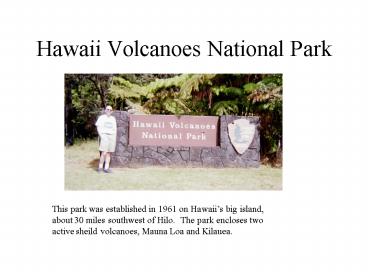
Hawaii Volcanoes National Park
This park was established in 1961 on Hawaiis big
island, about 30 miles southwest of Hilo. The
park encloses two active sheild volcanoes, Mauna
Loa and Kilauea.
2
Kilauea Visitor Center
The visitor center at the rim of Kilauea volcano
offers interesting exhibits, a gift shop, and an
excellent movie showing the history of the
Hawaiian Islands and volcanoes.
3
Kilauea Caldera
This caldera is a large circular depression at
the top of Kilauea volcano. Lava eruptions
flowed into this pit and hardened into black
basaltic rock 50 times during the years 1823 -
1982. Since 1983, the eruptions have occurred
on a flank of Kilauea several miles to the east
of this caldera. There is an 11 mile long road
which goes around the rim.
4
Geological History of Hawaiian Islands
Geologists believe that the Hawaiian Islands
represent an excellent example of the hot spot
theory of plate tectonics. These islands are
located in the middle of the Pacific Plate, a
plate which is thought to be currently moving
slowly to the northwest toward Japan. However,
a hot spot, a large hot plume of melted mantle
material extending deep into the earths
interior, is over the Hawaiian Islands in a fixed
(stationery) position. As the Pacific Plate
moved over this hot spot during the last 10
million years, the Hawaiian Islands arose as
volcanic rock one at a time in this order Kauai
is the oldest, followed by Oahu (famous for
Honolulu and Waikiki beach) , then Molokai-Maui-La
nai (all once one island), and finally the big
island of Hawaii, where the hot spot is currently
under. This explains why the volcanoes on the
big island, Mauna Loa and Kilauea, are active.
5
Fumaroles in Kilauea Caldera
Although lava is not currently flowing in the
Kilauea Caldera (current lava is flowing several
miles east of the caldera), there are still some
fumaroles venting hot steam and sulfur there.
6
Crater within Kilauea Caldera
This shows a smaller crater within the larger
Kilauea Caldera. Kilauea has several of these and
they represent periods of eruptions over the last
hundred years. Currently, the lava has hardened
into black basaltic rock.
7
Kilauea Rift Zone
This is a long narrow valley where lava flowed
out in 1982 along a flank rift east of the
Kilauea caldera.
8
Thurston Lava Tube
Visitors to the Hawaii Volcanoes National
Park are allowed to hike inside this ancient lava
tube . The hike is a few hundred yards long.
9
Pahoehoe Lava Flow
This is an excellent example of the Pahoehoe, or
ropy, variety of lava flow in Hawaii. This one
formed in 1982 east of Kilauea when fluid
basaltic magma was extruded along a long rift, or
crack, and then solidified here. The other
variety or AA flow, is more blocky and viscous,
and can be seen at other places.
10
Mauna Loa Volcano
Here we can see the summit of Mauna Loa volcano
in the distance. This is an excellent example of
a shield volcano, a broad, but not too high
mountain (this one is just over 13,000 feet
high). This is the worlds largest active
volcano and was formed when 40,000 cubic
kilometers of fluid basaltic lava was extruded
over the period of the last one million years.
It is located just west of the Kilauea Caldera on
Hawaiis Big Island. Because the hot spot is
under the big island, this volcano is consider
still active and erupted only 20 years ago.
11
Lava Entering the Sea
Here we can see steam rising from the Pacific
Ocean on the southeastern shore of the big island
of Hawaii. From a dangerous hiking path closer
up, you can see the actual lava which is
flowing down to the sea, thus causing this steam
to rise up. The lava is currently flowing out of
an area to the east of the Kilauea Caldera.
12
New coastline being added to Hawaii
This coastline on the southeastern shore of
Hawaiis big island was created as lava which
flowed during the period 1969-1974 flowed down to
the sea and solidified. This area is east of the
Kilauea Caldera.
13
Pahoehoe lava flows near sea
Recommended
CrystalGraphics Presentations


