
Hurricanes - PowerPoint PPT Presentation
1 / 55
Title:
Hurricanes
Description:
... that develop when 3 main atmospheric conditions occur simultaneously in the central US ... Isabel. Juan. Kate. Larry. Mindy. Nicholas. Odette. Peter. Rose ... – PowerPoint PPT presentation
Number of Views:88
Avg rating:3.0/5.0
Title: Hurricanes
1
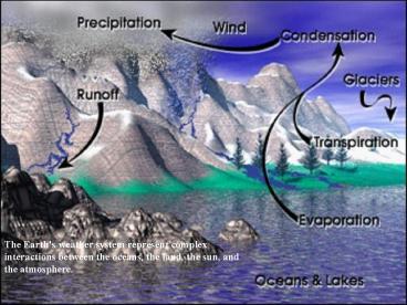
The Earth's weather system represent complex
interactions between the oceans, the land, the
sun, and the atmosphere.
2
(No Transcript)
3
- Weather is the condition of the atmosphere at a
particular time and place. It refers to such
conditions of the local atmosphere as - temperature,
- atmospheric pressure,
- humidity (the amount of water contained in the
atmosphere), - precipitation (rain, snow, sleet, hail),
- wind velocity.
4
- Vertical Structure of the Atmosphere
- General trends with increasing altitude
- Constituent gases tend to decrease in density
- Air pressure decreases
- Water vapor decreases dramatically
- Temperature fluctuates decreases in the
troposphere where weather occurs.
5
Composition of the Atmosphere
- The gaseous envelope that surrounds the planet.
- Because air pressure decreases with altitude, the
amount of air per unit volume (density) also
decreases with altitude. - The relative proportions of the gases in the air
are essentially constant regardless of altitude.
Nitrogen, Oxygen, and argon make up 99.96 of the
gases by volume.
6
Greenhouse Effect
- Carbon dioxide, water vapor, methane, greenhouse
gases and chlorofluorocarbons (CFC's) are some
greenhouse gases of anthropogenic origin. - .
7
Air Pressure
- Air pressure decreases with altitude. At any
given altitude, the air pressure is caused by the
weight of air above. This means that the air
near the ground is compressed by the weight of
the air above it. - As air pressure decreases, air density decreases.
8
Water Vapor in the Atmosphere
- Water can exist in all 3 states at the normal
range of earth temperature and pressure. - Whenever matter changes from one state to
another, energy is either absorbed or released. - From gas to liquid - condenstation - heat energy
is released - From liquid to gas - evaporation - heat energy is
absorbed
9
Relative Humidity
- Air is saturated when evaporation condensation.
Temperature dependent. - Saturation vapor pressure of air at any given
temperature cannot be exceeded. - Relative humidity the ratio of the vapor
pressure in a parcel of air to the saturation
vapor pressure at the same temperature.
10
Therefore, relative humidity can be changed by...
- Changing the water vapor content.
- Add water, increase relative humidity
- subtract water, decrease relative humidity
- Changing the temperature.
- Increase temperature, decrease relative humidity
- Decrease temperature, increase relative humidity.
11
Adiabatic Processes
- Processes that occur without the addition or
subtraction of heat from an external source. - Compressional warming - when air is compressed,
the temperature rises. - Expansional Cooling - when air expands, the
temperature decreases. - Because Air pressure decreases with increasing
altitude, rising air expands and sinking air is
compressed. - The adiabatic lapse rate - the way temperature
changes with altitude in rising or falling air.
12
Upward movement of air results from
- Density lifting - When warm, low-density air
rises convectively and displaces cooler, denser
air. - Orographic lifting - When flowing air is forced
upward over a mountain range. - Convergence lifting - when flowing air masses
converge and are forced upward. - Frontal lifting - when two flowing air masses of
different density meet.
13
Warm Front
14
Cold Front
15
Atmospheric Stability
- Two assumptions
- Lifting processes force air upward.
- Rising air does not mix substantially with the
surrounding atmosphere. - A parcel of air forced to rise will expand and
cool adiabatically. - Lifting condensation level altitude at which
the rising parcel reaches saturation temperature
and cloud forms.
16
Atmospheric Stability
- Atmospheric stability is a property of air that
describes its tendency to remain in its original
position (stable) or to rise (unstable) once the
initial lifting force ceases.
17
Atmospheric Stability
- Stable air - if an air parcel that is forced
aloft cools faster than the surrounding
environment. - Cloud formation may occur when the saturation
temperature is reached, but clouds would be
layered without much vertical development - fair
weather clouds. - If the lifting forced ceased, the parcel would
have the density to sink.
18
Atmospheric Stability
- Unstable air - if an air parcel that is forced
aloft cools slower than the surrounding
environment. - If the lifting force ceased, the parcel will
continue to rise because it is warmer and more
buoyant than its surroundings. - If the air parcel rises to its condensation
level, clouds with vertical development will form
as the buoyant air rises on its own -
thunderstorm clouds.
19
Tornadoes
How a Tornado Works - Associated with strong
thunderstorms that develop when 3 main
atmospheric conditions occur simultaneously in
the central US 1) a northerly flow of warm,
moist air from the Gulf of Mexico 2) a cold,
dry air mass rapidly moving southward from Canada
or the Rocky Mountains 3) strong easterly jet
stream - These three air masses moving in
different directions produce shearing conditions
that are give thunderstorm clouds a "spin" -
Funnel clouds begin to form, they may (or may
not) touch down and develop into a tornado.
20
Tornadoes.
- Warm moist air tropical air shoots upward as it
meets colder, dryer polar air. As the warm moist
air rises, it may meet varying wind directions at
different altitudes due to a strong westerly jet
stream. If these varying winds are staggered in
just the right manner with sufficient speed, they
will act on the upward rising air, spinning it
like a top.
21
Tornado Characteristics
- About 70 of all tornadoes on Earth occur in the
central and southern US. - One section of the nation is best at producing
tornadoes. This area is called "Tornado Alley,"
(shown on the map).- Northern Texas and Oklahoma - Occur mostly in late spring - early summer when
conditions are best for tornado formation but
can occur anytime. - Can move at speeds up to 60 mph and have max
wind speeds of 300 mph.
22
Tornado "magnitude" measured on the Fujita Scale
(F0-F5) based on Damage
23
Wind
- Wind is a horizontal air movement arising from
differences in air pressure. - Wind results when air flows from a place of high
pressure to one of low pressure.
Isobars - lines connecting places of equal air
pressure on a map.
24
Wind
- The spacing of the isobars indicates the amount
of pressure change over a given distance
pressure gradient. - Compare to the slope of a hill
25
Wind Summary
- Horizontal pressure gradient is the driving
force. - Magnitude is determined from the spacing of the
isobars. - Direction is always from areas of high pressure
to areas of low pressure (perpendicular to the
isobars).
26
Coriolis Effect
- Due to the rotation of the earth on its axis.
- Deflects all free moving objects to the right of
their path in the Northern Hemisphere and to the
left in the Southern Hemisphere. - Strongest at the poles, nonexistent at the
equator.
27
The Coriolis Force and Wind
- Deflects to the Right in the Northern Hemisphere,
Left in the Southern Hemisphere. - Deflection increases with wind speed.
- Deflection is strongest at the poles and weakens
equatorward.
28
Convergent and Divergent Flow
- In the Northern Hemisphere
- Around a low pressure cell, an inward
counterclockwise flow develops Centers of low
pressure are called cyclones convergent flow - Around a low pressure cell, an outward clockwise
flow develops. Centers of high pressure are
called anticyclones divergent flow.
29
Low pressure center generally related to unstable
conditions and stormy weather
Vertical Flow
Net downward movement of air and fair weather
Net upward movement of air, often resulting in
cloud formation and precipitation.
30
Around a surface high air is spiraling outward,
which leads to a downward flow of air at the
center of the high and convergence aloft.
Around a surface low air is spiraling inward,
which leads to an upward flow of air at the
center and divergence aloft.
31
HURRICANES
- A hurricane is a massive tropical cyclone with
rotary winds that exceed 74mph blowing
counterclockwise around a relatively calm central
area of very low pressure. - Hurricanes in the Atlantic and East Pacific,
typhoons in the west pacific, cyclones in the
Indian Ocean and Southern Hemisphere. - Form in late summer and early fall when ocean
waters are warmest.
32
Tropical systems are classified into four
categories according to its degree of
organization and maximum sustained wind
speed. Tropical disturbance, tropical wave
Unorganized mass of thunderstorms, very little,
if any, organized wind circulation. Tropical
depression Has evidence of closed wind
circulation around a center with sustained winds
from 20-34 knots (23-39 mph). Tropical storm
Maximum sustained winds are from 35-64 knots
(40-74 mph). The storm is named once it reaches
tropical storm strength. Hurricane or typhoon
Maximum sustained winds exceed 64 knots (74 mph).
33
Hurricane Formation
The process by which a tropical cyclone forms and
subsequently strengthens into a hurricane depends
on three conditions 1. A pre-existing
disturbance with thunderstorms (typically
emerging from the coast of Africa) 2. Warm (at
least 80ºF) ocean temperatures to a depth of
about 150 feet 3. Light upper level winds that
do not change much in direction and speed
throughout the depth of the atmosphere (low wind
shear)
34
Hurricane Formation
- Heat and energy for the storm are gathered by the
disturbance through contact with warm ocean
waters. The winds near the ocean surface spiral
into the disturbance's low pressure area. The
warm ocean waters add moisture and heat to the
air which rises. As the moisture condenses into
drops (thunderstorm bands), more heat is
released, contributing additional energy to power
the storm. If weather and ocean conditions
continue to be favorable, the system can
strengthen and the storm begins to take on the
familiar spiral appearance due to the flow of the
winds and the rotation of the earth (the stronger
the winds, the greater the coriolis deflection).
35
Warm, humid air spirals in from the sides and
rises, dumping vast amounts of rain and releasing
heat in the process. The heated, rising air
creates very low atmospheric pressures so low
that the pressure in the upper atmosphere above
the storm is actually higher than in the lower
atmosphere in the center of the storm. This
causes a downward flow of air in the center of
the storm, forming the eye of the hurricane.
36
Hurricanes
37
Once hurricanes form, they are pushed west with
the prevailing west-blowing winds in tropics. The
Coriolis force causes storms north of the equator
to travel in right-curving paths, and storms
south of the equator to travel in left-curving
paths.
38
The Hurricanes End
- Strong upper level winds shear tear the hurricane
apart. - Moving over cooler water can lead to weakening.
- Moving over land shuts off the moisture source
and reduces surface circulation due to friction.
39
Weather Alerts
- A tropical-storm watch is issued when sustained
winds from 39 to 73 mph (54.7 to 117.48 kph / 34
to 63 kt) are possible in your area within 36
hours. - A tropical-storm warning indicates that these
conditions are likely in your area within 24
hours. - A hurricane watch is issued when hurricane
conditions (sustained winds greater than 74 mph /
119 kph / 64 kt) are possible in your area within
36 hours. - A hurricane warning is issued when these
conditions are likely in your area within 24
hours.
40
Hurricane Damage Storm surges are like a hill
of ocean water (sometimes as high as 20ft above
sea level) pushed up by a hurricane. Storm surges
are caused by two factors low atmospheric
pressure that pulls the ocean surface up, and the
spiraling, converging winds that push the ocean
water in toward the center of the storm.
Storm surges cause far more death and destruction
than the high winds in a hurricane.
41
Ocean-front property is particularly susceptible
to damage from hurricane storm surges, when ocean
waves are very high and strong because of the
strength of the hurricane's winds.
42
Storm Surge
43
Flooding
- Hurricanes frequently produce huge amounts of
rain, and flooding can be a significant problem,
particularly for inland communities. A typical
hurricane brings at least 6 to 12 inches of
rainfall to the area it crosses.
44
Many communities and small towns in eastern North
Carolina found themselves afloat following
Hurricane Floyd's massive rainfall and the
ensuing floods. Streams and waterways were
already swollen from Hurricane Dennis, which
struck eastern North Carolina (twice) just weeks
before Hurricane Floyd.
45
Winds
- Hurricane winds not only damage structures, but
the barrage of debris they carry is quite
dangerous to anyone unfortunate enough (or unwise
enough!) to be caught out in them.
46
Hurricanes often cause severe structural damage.
This building, in the U.S. Virgin Islands, was
leveled.
47
(No Transcript)
48
Hurricane prediction Hurricanes can be predicted
to some degree. Wind directions, sea surface
temperatures, and behavior of past storms can be
used to issue warnings about storm development,
possible landfall location, and storm size.
However the storms can unpredictably weaken,
strengthen, or change direction.
Weather satellites use different sensors to
gather different types of information about
hurricanes Visible - clouds, circulation
patterns Radar / Doppler radar - rain, wind
speeds, precipitation amounts Infrared -
temperature differences, cloud heights
49
Visible Images
50
Doppler Radar
51
Infrared
52
This photo is a composite of three days' views
(August 23, 24 and 25, 1992) of Hurricane Andrew
as it slowly moved across south Florida from east
to west.
53
Hurricane Floyd was a Category 3 storm that
brought intense rains and record flooding to the
eastern United States and Canada. Nearly 90
percent of the fatalities associated with this
storm were drownings due to inland flooding.
54
Hurricane Names
- When the the winds from these storms reach 39
mph (34 kts), the cyclones are given names. - Years ago, an international committee developed
names for Atlantic cyclones. In 1979 a six year
rotating list of Atlantic storm names was adopted
alternating between male and female hurricane
names.
55
2006 Alberto Beryl Chris Debby Ernesto Florence Go
rdon Helene Isaac Joyce Kirk Leslie Michael Nadine
Oscar Patty Rafael Sandy Tony Valerie William
2008 Arthur Bertha Cristobal Dolly Edouard Fay Gus
tav Hanna Ike Josephine Kyle Lili Marco Nana Omar
Paloma Rene Sally Teddy Vicky Wilfred
2004 Alex Bonnie Charley Danielle Earl Frances Gas
ton Hermine Ivan Jeanne Karl Lisa Matthew Nicole O
tto Paula Richard Shary Tomas Virginie Walter
2005 Arlene Bret Cindy Dennis Emily Franklin Gert
Harvey Irene Jose Katrina Lee Maria Nate Ophelia P
hilippe Rita Stan Tammy Vince Wilma
2007 Allison Barry Chantal Dean Erin Felix Gabrie
lle Humberto Iris Jerry Karen Lorenzo Michelle Noe
l Olga Pablo Rebekah Sebastien Tanya Van Wendy
2009 Ana Bill Claudette Danny Erika Fabian Grace H
enri Isabel Juan Kate Larry Mindy Nicholas Odette
Peter Rose Sam Teresa Victor Wanda
Recommended
CrystalGraphics Presentations


