
Citrus Canker and Citrus Greening (HLB) Published Map - PowerPoint PPT Presentation
1 / 11
Title:
Citrus Canker and Citrus Greening (HLB) Published Map
Description:
Using Bookmarks. Hyperlinks. Help. ESRI ArcReader Help. ESRI Online Help ... Using Book Marks. Using Book Marks will allow you to quickly find and zoom to ... – PowerPoint PPT presentation
Number of Views:483
Avg rating:3.0/5.0
Title: Citrus Canker and Citrus Greening (HLB) Published Map
1
Citrus Canker and Citrus Greening (HLB) Published
Map
2
- Table of Contents
- Overview
- Data Description
- Basic Toolbar Overview
- Zoom and Pan
- Data Layout
- Page Layout
- Use Cases
- Finding Features
- Finding an Office
- Finding a County
- Finding a City
- Finding a TRS
- Finding an Address
- Using Bookmarks
- Hyperlinks
- Help
- ESRI ArcReader Help
- ESRI Online Help
3
Overview
The information depicted with this application is
for general reference only. The Citrus Canker
and Citrus Greening (HLB) data represents only
known and confirmed positive sample locations.
This includes all residential and commercial
finds from January 01, 2004 to present
- Data Description
- Cities
- Field Names
- OID, Shape, Name
- Offices
- Field Names
- OID, Shape, Office, Contact, Address, Phone, Map
Tip - HLB Specimens
- Field Names
- OID,
- Citrus Canker
- Field Names
- OID, Shape, Sample_ID
- US State Highways
- Field Names
- OID, Shape, Name, Shape_Length
4
Basic Toolbar Overview
- Zoom In Button
- Zoom in to Location
- Zoom Out Button
- Zoom out to wider extent
- Full Extent Button
- View full extent of data
- Pan Button
- Pan to Location
- Page Layout
- View map in print layout
- Hyperlinks
- Allows viewing of additional information by
displaying links to documents and web pages - Refresh Map
- Refresh layers in map table of contents
- Find Features
- Find and Zoom to locations, Address, and Features
5
Use Cases
- Finding Features
- Use the Find Features button to locate features
on the map such as Addresses, PLSS Sections,
Counties, Cities, Office Locations - Once a feature is located you can right click on
the record and use the context menu depicted here
to Zoom To, Pan to, Add Marker etc.) - Finding an Office
- In the Find field type in the name of the office
that you wish to locate (e.g. Avon Park or Winter
Haven) - In the In field select the CHRP Office Locations
layer from the drop down - Click the In Field radio button and select Office
from the drop down - Click the Find button
6
Use Cases
- Finding Features
- (Cont.)
- Finding a County
- In the Find field type in the name of the County
that you wish to locate (e.g. Desoto or Polk) - In the In field select the Florida Counties Map
Grid layer from the drop down - Click the In Field radio button and select Title
from the drop down - Click the Find button
7
Use Cases
- Finding Features
- (Cont.)
- Finding a City
- In the Find field type in the name of the City
that you wish to locate (e.g. Tampa or Winter
Haven) - In the In field select the Cities layer from
the drop down - Click the In Field radio button and select Name
from the drop down - Click the Find button
Note Only larger cities are included in this
dataset others will not be found
8
Use Cases
- Finding Features
- (Cont.)
- Finding a PLSS Section
- In the Find field type in the name of the PLSS
Section that you wish to locate (e.g. 38S25E03) - In the In field select the PLSS Sections layer
from the drop down - Click the In Field radio button and select TRS
from the drop down - Click the Find button
Note In order for the Find tool to find the PLSS
Section correctly you must enter the number in
TRS (Township, Range, Section) order including
the directional indicators. E.g. 38S25E03
9
Use Cases
- Finding Features
- (Cont.)
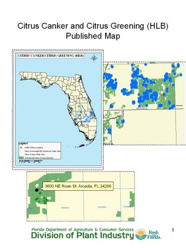
- Finding an Address
- Click the Find button from the main toolbar
- Click the Address tab
- In the Country field select United States from
the drop down - In the Street or Intersection field type in the
address that you wish to find (e.g. 3600 NE Roan
Rd) - In the City field type in the city of the
address that you wish to find (e.g. Arcadia) - In the State/Province select Florida from the
drop down - In the Zip/Postal Code field type in the zip
code of the address that you wish to find (e.g.
34266) - Click the Find button
Note The Find Address tool uses a free address
locator provided by ESRI. In order to use this
feature users must be connected to the internet.
10
Use Cases
- Using Book Marks
- Using Book Marks will allow you to quickly find
and zoom to areas that may frequently be of
interest to you - Click View from the toolbar
- Highlight Bookmarks
- Click on the bookmark that you wish to view
- Using Hyperlinks
- Hyperlinks allow you to see additional
information about features by linking to items,
such as documents and web pages - Click the Hyperlinks button from the toolbar
- Click on any of the office locations to be linked
to the address and contact information of that
office - Note Currently the only layer that has
hyperlinks enabled is the CHRP Office layer
11
Help
- ESRI ArcReader Help
- To access ArcReader help at any time click Help
on the toolbar or use the F1 key - ESRI Online Help
- To access ArcReader Online Help click Help on the
toolbar and select ArcReader Online Help - Or visit www.esri.support.com
- Division of Plant Industry Help Line
- For an questions regarding the content of the map
please call our toll free Help Line at
1-800-282-5153
Recommended
CrystalGraphics Presentations


