
The GEON Integrated Data Viewer IDV and IRIS DMC Services: - PowerPoint PPT Presentation
1 / 1
Title:
The GEON Integrated Data Viewer IDV and IRIS DMC Services:
Description:
The IRIS Earthquake Browser (IEB) is an interactive map service for finding and ... The user chooses earthquake times, locations, depths, magnitudes, and how ... – PowerPoint PPT presentation
Number of Views:56
Avg rating:3.0/5.0
Title: The GEON Integrated Data Viewer IDV and IRIS DMC Services:
1
The GEON Integrated Data Viewer (IDV) and IRIS
DMC Services CyberInfrastructure Support for
Seismic Data Visualization and Interpretation Cha
rles Meertens and Stuart Wier (UNAVCO) Tim
Ahern, Rob Casey, Bruce Weertman, and Chris
Laughbon (IRIS) AGU Fall Meeting December 19,
2008
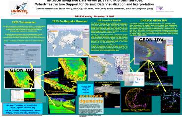
UNAVCO GEON IDV The GEON IDV is a fully
interactive true 3D system, with time animation,
to display and explore any data located on the
Earth, inside the Earth, or above the Earth's
surface. It is excellent for use in solid earth
sciences. If your data is 2D, 3D, or 4D grids,
point observations, imagery mapped on the Earth,
tracks or soundings, or most any data mapped in
or on the Earth, you can interactively display it
and explore it with the GEON IDV.
IEB Search Results The IRIS Earthquake Browser
(IEB) is an interactive map service for finding
and downloading earthquake epicenters from the
IRIS database. In total, the database contains
more than 2 million unique events dating from the
early 1960s until present. Data can be exported
from the IEB and viewed in 3D with the GEON
Integrated Data Viewer. The IEB is useful both
educationally and as a research tool. The IEB is
a Google Map mashup composed of Google Map, HTML,
and Javascript code, interfacing with the IRIS
earthquake epicentral catalog. The user chooses
earthquake times, locations, depths, magnitudes,
and how many events to show. The user can quickly
discover all of the earthquakes held in the IRIS
database for any region of the globe. Earthquakes
shown on the IEB map may be viewed in a table, or
exported in NetCDF or XML formats. The GEON
Integrated Data Viewer program (IDV) can be used
to visualize and examine, in true 3D, the
earthquakes in the exported NetCDF data.
IRIS Earthquake Browser
IRIS Tomoserver The IRIS Tomoserver will be an
online service for seismologists to convert their
tomography data in variety of ASCII formats to
the NetCDF format so that the data may be
displayed and explored in the GEON IDV.
Scientists may contribute their own tomography
moldel to IRIS for public use, so that others
may use the Tomoserver to download tomography
for use in the GEON IDV. Here is a prototype of
the IRIS Tomoserver online interface.
GEON IDV
IDV tomography isosurfaces and horizontal
cross-section
GEON IDV
The IEB and IDV both make KML files
- Unidata's newest scientific analysis and
visualization tool - Freely available Java framework and reference
application - Provides 2- and 3-D displays of geoscientific
data - Stand-alone or networked application
- Built on VisAD library
IDV terrain display of Mt. St. Helens and
seismicity
For more, just google GEON IDV or IRIS IEB
IDV tomography isosurfaces and vertical
cross-sections
Acknowledgements UNAVCO is funded by the
National Science Foundation (NSF), the
USGS, and the National Aeronautics and Space
Administration (NASA). GEON IDV is funded by
the NSF GEON Project. Support for IRIS comes
from the National Science Foundation
(including the EAR Instrumentation and
Facilities Program, EarthScope, and Office of
Polar Programs), other federal agencies,
universities, and private foundations. We
thank science investigators for their advice
and assistance.
IDV tomography vertical profile
UNAVCO's GEON IDV web site http//geon.unavco.
org The IRIS Data Management Center http//www.i
ris.edu/dms/dmc/
IDV tomography isosurfaces and vertical
cross-sections
IDV Globe display of IRIS earthquakes
Recommended
CrystalGraphics Presentations


