
GIS analysis - PowerPoint PPT Presentation
1 / 23
Title:
GIS analysis
Description:
... analysis differentiates GIS from computer assisted mapping (CAD), both spatially ... GIS resulted from the need to OVERLAY different map layers: ... – PowerPoint PPT presentation
Number of Views:239
Avg rating:3.0/5.0
Title: GIS analysis
1
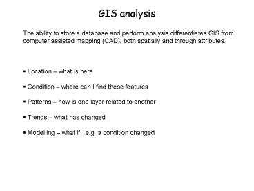
GIS analysis
- The ability to store a database and perform
analysis differentiates GIS from computer
assisted mapping (CAD), both spatially and
through attributes. - Location what is here
- Condition where can I find these features
- Patterns how is one layer related to another
- Trends what has changed
- Modelling what if e.g. a condition changed
2
http//damncoolpics.blogspot.com/2008/12/9-gigant
ic-hearts-from-above.html
Nice summer job Mountain legacy project
http//mountainlegacy.uvic.ca/
3
Data preparation
Transform - modify by projection, clip and
erase Classify - dissolve, append, join,
group, merge, generalize
Commonly used analytical tools in arcgis
append, buffer, clip, dissolve, integrate,
intersect, union, erase
4
1. Location query what is here?
5
2. Condition- selection where are these
Utilises Boolean logic applied to spatial data or
attributes Boolean Logic (named after George
Boole, a 19th century mathematician)
Create an expression
reducible to a true or false condition. Logical
Operators
6
Boolean Operators
Boolean Operators (to combine items or layers)
AND OR NOT
XOR These often require the use of brackets to
avoid ambiguity in complex queries e.g type
pine AND age gt 100 ... selects all old growth
pine type pine OR age gt 100 selects all pine
and any type older than 100 type pine OR type
fir AND age gt 100.. selects any pine and old
growth fir type (pine OR type fir) AND age
gt 100 .. selects old growth (pine and fir)
7
Most analysis relies on three topological
relationships Topology shape or form
Contiguity (Adjacency and Proximity)
Connectivity
Containment
8
3. Patterns Overlay
GIS resulted from the need to OVERLAY different
map layers Many cite the example of the Irish
Railway Atlas (1850) which showed population,
traffic flow, geology and topography overlain on
the same base map, a predecessor of a GIS map
The term GIS was first used by the developers
of the CGIS (Canadian), the world's first
operational GIS in Ottawa, 1971. This project
designed a computer system to input and manage
the database for the Canada Land Inventory (CLI).
This was driven by the need to manage the land
based on overlaying layers to generate land
capability (see example on the CLI website) Its
leader Roger Tomlinson is widely regarded as the
'Father of GIS'.
9
The Concept of Map Overlay
- Map overlay addresses the relationship of the
intersection and overlap between spatial
features. - Map overlay combines the spatial and attribute
data of two input themes. - Three input feature types, overlay cover is
always polygon - 1) point-in-polygon, points
are output - 2) line-in-polygon, lines
are output - 3) polygon-in-polygon polygons
are output
10
(No Transcript)
11
(No Transcript)
12
(No Transcript)
13
Overlay Methods UNION, INTERSECT, IDENTITY
Union
- or Boolean operator.
- creates new coverage by overlaying two polygon
coverages. - the output coverage contains
- the combined polygons
- attributes of both coverages
- all coverages must be polygons
What is the combination of the stands and fire
area ?
union
14
Intersect
- and Boolean operator.
- creates a new coverage by overlaying two sets of
features. - the output coverage contains only those portions
of features that are in the area occupied by both
the input and intersect coverages.
Where do the stands and the fire intersect?
intersect
15
Identity
- creates a new coverage by overlaying two sets of
features. - the output coverage contains
- all of the input features
- keeps only those portions of identity coverage
features that overlap the input coverage.
Where did fire occur in the stands database ?
16
3. Patterns Distance
- cost surfaces, distance to features, buffer
17
(No Transcript)
18
Variations on Buffering
- Variable buffer distances (assigned by attribute)
- Different buffer size depending on stream size
- Class (quality) of water
- Stream protection status
Salmon species caught
Culvert prevents fish movement
flow
19
Buffers applied to points, lines and polygons
20
3 Patterns Networks
- a system of interconnected lines requiring
topology connectivity - http//www.ordnancesurvey.co.uk/oswebsite/gisfiles
/section4/page4.html - e.g. hydrological, transportation, utilities
network analyst
21
4 and 5 Trends and Modeling
What changed and what will change ? comparison
of temporal layers - e.g. fire spread based on
fuel type, wind speed, direction, buffers,
topography Change change effects, e.g. polar
ice beetle spread fires, volcanoes etc..
22
Mini-project 09
23
Mini-project TRIM data
minipro1.jpg minipro2.jpg
minipro3.jpg
Recommended
CrystalGraphics Presentations


