
ISAT 212 ENERGY ISSUES IN SCIENCE AND TECHNOLOGY - PowerPoint PPT Presentation
1 / 13
Title:
ISAT 212 ENERGY ISSUES IN SCIENCE AND TECHNOLOGY
Description:
Costa Rica is an absolute paradise in matters of beaches. ... and coral reef beaches and the ones with ... This beach offers a very thick and voluminous wave. ... – PowerPoint PPT presentation
Number of Views:73
Avg rating:3.0/5.0
Title: ISAT 212 ENERGY ISSUES IN SCIENCE AND TECHNOLOGY
1
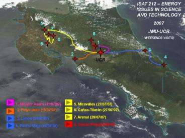
ISAT 212 ENERGY ISSUES IN SCIENCE AND
TECHNOLOGY 2007 JMU-UCR (WEEKENDS VISITS)
5
7
8
5
1
6
3
2
4
UCR
1. Mirador Aserrí (11/07/07)
5. Miravalles (27/07/07)
2. Playa Jaco (15/07/07)
6. Cañas-Tilarán (27/07/07)
7. Arenal (29/07/07)
3. Limón (21/07/07)
8. Volcán Poás(04/08/07)
4. Puerto Viejo (22/07/07)
2
VOLCAN POAS
Botos Lagoon is a filled-up crater in the Parque
Nacional Volcan Poas. Its deep blue waters
contrast with the dense tropical forest that
surround it, making it the perfect spot for the
stereotypical Indian sacrifice- throwing a young
maiden into the mouth of a crater or a lagoon.
Volcan Poas is one of the most visited volcanoes
in Costa Rica, because of its proximity to San
Jose and because of the luxuriant forest that
surrounds the two craters. The park measures 5600
hectares, and this basaltic volcano stands at an
altitude of 2708 meters (8,200 feet) above sea
level.
PUSH TO RETURN
3
ARENAL
Arenal is considered Costa Rica's most active
volcano and has been studied by seismologists for
many years. Although the activity nowadays is
less damaging, you can still see ash columns,
underground rumbling, glowing orange lava flows
and sudden explosions on a daily base. With its
perfect conical shape it allows breathtaking
views of volcanic action in the summit. Almost
every night the crater offers a spectacle of
lights with its explosive eruptions. The volcano
is located in the northern zone of the country,
fifteen kilometers southwest of La Fortuna in San
Carlos. The temperature varies from 16 degrees
Celsius (60,8 degrees Fahrenheit) in the high
areas to 24 degrees Celsius (75,2 degrees
Fahrenheit) in the low areas and the annually
rainfall is around 5,000 mm (195 inches). The
Arenal Volcano area is an important watershed for
the Arenal Lake Reservoir. Water from here is
used for hydroelectric power, with the purpose of
satisfying the electricity demand of the
inter-connected national system and the
Guanacaste irrigation projects.
PUSH TO CONTINUE
4
ARENAL HYDROELECTRIC PLANT
- Costa Ricas multiuse Proyecto de Riego
Arenal-Tempisque (PRAT) scheme was developed
between 1975 and 1978 and is administrated by the
Servicio Nacional de Aguas Subterráneas, Riego y
Avenamiento (SENARA). PRAT channels water from
the Arenal Lake, which originally used to flow
down the Caribbean basin, towards the Pacific
basin through a hydroelectric complex of three
power plants built in cascade Arenal, Corobici,
and Sandillal (ARCOSA), illustrated above from
left to right. Once the waters pass through these
facilities, they enter two irrigation canals.
Construction started on Arenal in 1974. The plant
has three 52.5-MW Fuji Francis turbines driving
Mitsubishi generators. Average annual generation
is about 640 GWh. Corobici is the second of the
three ARCOSA plants and has three 60-MW
Mitsubishi Francis turbines with Hitachi
generators. The plant went into service in 1982
and supplies about 730 GWh/yr to the Costa Rican
grid. Sandillal is the last of three
hydroelectric plants in the scheme. The plant has
two 16-MW Kaplan turbines from Voest driving
Siemens generators. Construction on Sandillal
started in 1987 and it went into operation in
November 1992.
PUSH TO RETURN
5
PLAYA JACO
Costa Rica is an absolute paradise in matters of
beaches. The coastlines have a never-ending
variety of it for any possible taste. There are
rocky, stony, sandy and coral reef beaches and
the ones with white, grey, bluish black, tan, and
pink coloured sand.
PUSH TO RETURN
6
MIRAVALLES
The Miravalles area is continually monitored,
as some seismic activity is taking place under
and inside the caldera. However, the last
recorded eruption of steam vents was in 1946.
Because the park contains a large underground
heated reservoir, it is the site of a geothermal
energy plant. The hydrothermal field is a
hot-water dominated system, with a vapor
dominated cap (few tens of meters thick) in some
parts of the geothermal field. Primary cloud
forest and rainforest covers the park, which
abounds with flora and fauna species in multiple
life zones, innumerable rivers, waterfalls and
thermal hot springs.
PUSH TO RETURN
7
LIMON
1. Limón, Limón 2. Pococí, Guápiles 3.
Siquirres, Siquirres 4. Talamanca, Bratsi 5.
Matina, Matina 6. Guácimo, Guácimo
PUSH TO CONTINUE
8
PLANTA TERMICA MOIN
PUSH TO CONTINUE
9
REFINADORA RECOPE MOIN
PUSH TO RETURN
10
RAM LUNA
Location In the mountains above Aserrí, south of
San José.Directions for Taxi Driver Del centro
de Aserrí, cuatro kilómetros sobre la carretera a
Tabarca. At the Ram Luna Restaurant in the hills
above Aserrí, the food is authentic, the
atmosphere is elegant and the view is
breathtakingly amazing. Guests will feel they
have the stars at their feet as they enjoy a
deliciously authentic Costa Rican dinner above a
vast sea of lights twinkling in the valley
below. The history of the popular Ram Luna
Restaurant began in May of 1967, when a young
newlywed couple named Gilbert and Moraima Ramírez
moved into a small mountain cabin with a view and
dreamt of building a restaurant where the
atmosphere was classy and the food
delicious. Today, the Ram Luna has become all
that and more. The elegant multilevel building
boasts a beautiful exterior view and a classy
interior where candles warm the comfortable
ambience. The service is excellent and the food
is uniquely Costa Rican.
PUSH TO RETURN
11
- CAÑAS
- El canton de la amistad", is found in the
northwest part of Costa Rica, in the Guanacaste
province, at the geographic coordinates given as
10 degrees 27 minutes and 04 seconds latitude
north and 85 degrees 06 minutes and 06 seconds
longitude west.The maximum width is 61 kms, from
4400 mts. west of the top of the hill of
Montezuma to 2500 mts south of the dock at the
Tempisque Ferry. The total area is about 682.2
square kms.
PUSH TO CONTINUE
12
TILARAN
- Gateway to Lake Arenal and the Arenal Volcano,
Tilaran is a charming town that lies in the
northeastern regions of Guanacaste province,
close to the border of Alajuela. Located along
the Pan American Highway some 4 km from Lake
Arenal, Tilaran is now fast becoming a key
location for adventures in and around the lake
area. A quaint little town 22 km from Canas,
Tilaran is also a major farming zone for coffee,
peanuts and macadamia nuts in the region as well
as for cattle and horse ranching
PUSH TO RETURN
13
PUERTO VIEJO
This beach offers a very thick and voluminous
wave. This wave comes from deep water over a
shallow reef that is called Salsa Barva. It is a
right reef break known for it's size and power.
The biggest waves in Costa Rica break here when
there is a swell. The only way to paddle in and
out is through a small channel in the reef, be
sure and observe a local paddle out before you
do.
Recommended
CrystalGraphics Presentations


