
The Gulf of Mexico: - PowerPoint PPT Presentation
1 / 36
Title: The Gulf of Mexico:
1
The Gulf of Mexico Understanding Americas Sea
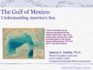
Coast and Geodetic Survey personnel developed the
first realistic bathymetric map of any oceanic
basin (above) from 3,000 soundings taken on the
Survey Steamer Blake between 1873 and 1875 in the
Gulf of Mexico
Jessica A. Kastler, Ph.D. Marine Education
Instructor Co-PI COSEE CGOM Louisiana
Universities Marine Consortium
2
The Gulf of Mexico is a semi-enclosed basin of
the ocean. With the Caribbean Sea it constitutes
Americas Inland Sea. The Gulf is bordered by
five states in the United States (Florida,
Alabama, Mississippi, Louisiana and Texas), six
in Mexico (Tamaulipas, Veracruz, Tabasco,
Campeche, Yucatan and Quintana Roo), and Cuba.
Of the semi-enclosed seas (like the
Mediterranean), the Gulf of Mexico is the most
intensely investigated and perhaps the best
understood.
http//www.tceq.state.tx.us/comm_exec/forms_pubs/p
ubs/pd/020/04-04/gulf.html
3
Surface area 1,500,000 sq km (580,000 sq
mi) West to East extent 1,600 km (994 mi)
North to South extent 900 km (559 mi)
4
20 major fresh-water river systems drain into the
Gulf, and near 65 of all river volume (and
pollution) flows into this massive body of water
through the Mississippi River Delta. In many
ways the Gulf of Mexico is like every other part
of the ocean. But there are also differences.
This presentation discusses the origins of the
Gulf of Mexico and makes some comparisons to
other parts of the world ocean in the context of
the four traditional disciplines of oceanography
Geology, Physics, Chemistry, and Biology.
http//www.golfo-de-mexico.org
5
The Gulf began to form in the Triassic Period
when North America began separating from Africa
as a result of a rift forming between the plates
currently known as North and South American
continents. By the mid-Jurassic, the Gulf was
receiving sediment from the proto-Mississippi
River.
GEOLOGY
http//www.paleoportal.org/index.php?globalnavtim
e_spacesectionnavperiodperiod_id9
6
Sedimentation continues today and has resulted in
vastly thick deposits of clastics (particles of
sand, silt, and clay carried by flowing water)
and carbonates (biogenic precipitation of calcium
carbonate mediated by organisms that use CaCO3
for their shells) around the edges of the
Gulf. Thickness of DepositsInterior of US Gulf
Coast states gt2 kmCoast of US Gulf Coast states
West of the Mississippi River 10 km East of
the Mississippi River 5 kmOffshore of
Louisiana 16 km The thick deposits sometimes
slump causing normal faults angling from the
horizontal toward the Gulf. These faults have
produced earthquakes, but typically have low
seismicity and experience slip along the fault
plane of of lt0.2mm/yr.
GEOLOGY
http//www.paleoportal.org/index.php?globalnavtim
e_spacesectionnavperiodperiod_id9
7
The rifting of continents in the mid-Mesozoic
split a large salt deposit and introduced new
ocean crust between them. The Louann Salt is
more than 200 million years old, formed by
evaporation of an ancient shallow sea on North
American continent. It is located below later
deposits along the Gulf of Mexico's shoreline. In
some places this salt has moved (deformed)
because of the weight of the rocks above.
Several scientists compare the movement to
toothpaste squeezing out of the tube. The tube
consists of increasingly heavy deposits
originating on land that smush the salt, or
toothpaste out below them toward the deeper
waters of the Gulf.
GEOLOGY
http//oceanexplorer.noaa.gov/explorations/02mexic
o/background/brinepool/gulf_salt_220.jpg
8
The blue line shows the northward extent of the
Louann Salt. Dark green dots show where the
deposit is deformed to make obvious structures by
its underground movement. On top of this salt
rests sandstone (clastic) deposited in an arid
environment during the Jurassic period. It
contains wind blown dunes up to 250 meters high
and 13 km long, 4,575 meters below the surface.
Above this formation are a limestone (carbonate)
and sandstone. Why do we care? 1 - It
certainly is neat to know how our part of the
world looked before we got here. 2 The
clastic and carbonate formations described above
are productive oil reservoirs from Texas and
Arkansas to Alabama. The deformation caused by
salt pushing through these layers makes traps to
which the oil migrates where it can be recovered
by drilling.
GEOLOGY
http//www.priweb.org/ed/pgws/backyard/sections/so
uthcentral/southcentral2.html
http//earthquake.usgs.gov/regional/qfaults/eusa/g
ulf.php
9
The vertical cross-section of a salt dome, shows
how previously horizontal layers of rock are
folded as the salt pushes upward. Shading in
each layer shows places where geologists and
engineers would look for oil essentially oil
migrates to the highest point in any porous and
permeable rock. Faults and bedding planes with
impermeable rocks cut off the migration allowing
the oil to collect.
GEOLOGY
http//www.geo.wvu.edu/jtoro/Petroleum/Review202
.html
http//earthquake.usgs.gov/regional/qfaults/eusa/g
ulf.php
10
This multibeam bathymetry map of the northwestern
and northern Gulf of Mexico continental shelf and
slope shows the topography of the area affected
by Louann salt layer and subsequent river
deposition, as well as an ancestral outlet of the
Mississippi River (the MR Canyon). Figure
provided to NOAA Ocean Explorer courtesy of Harry
H. Roberts.
GEOLOGY
http//oceanexplorer.noaa.gov/explorations/06mexic
o/background/geology/media/gulf_600.html
11
The topography developed by salt and river
deposition (labeled 2 in the figure) is not
typical for continental margins such as the
Atlantic Coast. Areas marked 1 are carbonate
platforms. They are edged by a steep cliff
(escarpment). Only the areas marked 3
illustrate the relatively shallow continental
slope and rise typically seen at the margin
between continental and oceanic crust.
GEOLOGY
http--oceanexplorer_noaa_gov-explorations-02mexico
-background-brinepool-gulf_salt_220.htm
12
The two carbonate platforms are geologically
similar and are thought to have been deposited
together in the early-late Jurassic after the
salt layer was deposited. Both the Florida and
Yucatan Platforms were initially exposed and only
subsided below sea level during late Jurassic
(Fla) and mid Cretaceous (Yuc) times. The
subsidence is assumed to be related to cooling of
the tectonic plates after rifting
occurred. Since the platforms submerged, they
have been experiencing deposition of carbonates
(in shallow marine reef environments) and
evaporites (in arid environments).
GEOLOGY
http//www.gulfbase.org/facts.php
13
Shoreline Length 5,700 km, Florida to
Yucatan 380 km, Cuba gt27,000 km, Shoreline
including US bays Basin Topography 38 Shallow,
intertidal lt20 m 22 Continental Shelf, 20-180 m
20 Continental Rise, 180-3000 m 20 Abyss,
gt3000 m Sigsbee Deep 4000 m Mean Depth 1615
m Volume 2,400,000 km3 Notice that the
deepest part of the Gulf the Sigsbee Deep
(Darkest blue on the figure) is between the two
portions of the salt layer. This is where
oceanic crust extruded to separate them.
GEOLOGY
http//www.gulfbase.org/facts.php http//www.intec
mar.usb.ve/CoMLCaribbean/Summaries/summary_BoGoM.h
tm http//ocean.colorado.edu/kantha/Altimetry/gul
f_of_mexico.html
14
CHEMISTRY
http//www.golfo-de-mexico.org http//www.coast-no
pp.org/resource_guide/elem_mid_school/physical_par
am_acts/saline.html
15
CHEMISTRY
http//www.dynalysis.com/Projects/projects.html
16
Get a copy of this excellent poster by contacting
the MMS http//www.gomr.mms.gov/homepg/ lagniapp/
lagniapp.html Brine Pools, barite chimneys, and
oil seeps are features of the Gulf seafloor that
influence its chemistry. All are closely
related to the deposition of salt and subsequent
rocks discussed earlier.
Brine pools form by dissolution of salt that has
migrated to the surface. Barite chimneys (20cm
high) occur when barium (frequently found in the
salt layer) meets sulfate in the in the sea
water. Oil seeps are caused by the migration of
oil from reservoir rock to the surface
(frequently near salt domes).
Gas hydrates (methane seeps) are another feature
of the Gulf floor. These are formed where ice
contains hydrocarbon like methane in its
crystalline lattice. They occur at low
temperature and high pressure (300-500 m).
All of these features are associated with unusual
communities. Chemosynthetic communities (in
which bacterial oxidize sulfide for an energy
source and therefore provide organic matter for
tubeworms and mussels to eat) are found near gas
hydrates and oil seeps.
CHEMISTRY
http//www.gomr.mms.gov/homepg/lagniapp/lagniapp.h
tml
17
No discussion of Gulf chemistry would be complete
without considering the input of nutrients from
the rivers that drain the Gulf watershed. These
nutrients include nitrogen, phosphorus and
silicon which phytoplankton use to
photosynthesize in the presence of sunlight. The
microscopic algae use N and P to make their
organic parts, while they use the Si to
precipitate biogenic silica as tests (small
shells) for protection. The large freshwater
inflow contributes to a large phytoplankton
population and encourages productive food webs
and healthy commercial fisheries throughout the
Gulf of Mexico. Falling particles from dead
phytoplankton, zooplankton and fecal pellets
deliver the organic material to the bottom of the
Gulf where decomposition of the organic material
releases the nutrients to the deep water
CHEMISTRY
http//www.gomr.mms.gov/homepg/lagniapp/lagniapp.h
tml
18
Circulation in the Gulf of Mexico is part of the
large-scale ocean circulation that connects
different basins and moves water while balancing
heat exchange between polar and equatorial
oceans. Surface circulation is most easily
observed using sea surface temperature images
obtained from satellites.
This thermal figure is built by collecting and
coding similarly pixels around the warmest
pixel in a group from a sequence of night time
imagery (obtained every 30 minutes) spanning
about 10 hours. The pixel size is 4km in size.
PHYSICS
http//www.esl.lsu.edu/research/CMI-GOES/s
19
Sea surface height is related to sea surface
temperature in part by the relationship between
temperature and density. Hotter water will have
greater height because it is less dense. This
figure shows a hill of higher water coming into
the Gulf from the Caribbean via the Yucatan
Strait.
PHYSICS
http//www.esl.lsu.edu/research/CMI-GOES/s
20
Another factor that contributes to sea-surface
height is flow velocity. Clockwise
(anticyclonic) flow coincides with high central
pressure and pushes water up to make a small hill
in the middle of circulating gyres. Arrows show
direction and relative speed of water.
PHYSICS
http//www.csi.lsu.edu/physi.ocean.asp
21
Gulf Stream
Loop Current
eddy
Florida Strait
Yucatan Strait
week ending 1/17/98
PHYSICS
http//www.ssmi.com/rss_research/viewing_ocean_cur
rents_with_sst.html
22
week ending 1/24/98
PHYSICS
http//www.ssmi.com/rss_research/viewing_ocean_cur
rents_with_sst.html
23
week ending 1/31/98
PHYSICS
http//www.ssmi.com/rss_research/viewing_ocean_cur
rents_with_sst.html
24
week ending 2/7/98
PHYSICS
http//www.ssmi.com/rss_research/viewing_ocean_cur
rents_with_sst.html
25
week ending 2/14/98
PHYSICS
http//www.ssmi.com/rss_research/viewing_ocean_cur
rents_with_sst.html
26
week ending 2/21/98
PHYSICS
http//www.ssmi.com/rss_research/viewing_ocean_cur
rents_with_sst.html
27
Chlorophyll a is produced by the phytoplankton
that thrive in the nutrient rich coastal waters
of the Gulf. The images show variation in the
amounts of chlrophyll a and thus phytoplankton
production in the eastern Gulf of Mexico for
specific dates. The rainbow legend has two small
white numbers in all cases the number on the
left is 0 and the number on the right is 4
(mg/cm3). But the color of 4 is darker in the
May figure. So what does this say about
production in May versus December this
year?
The figures were produced using the Ocean
Color Monitor (OCM), a satellite image used to
estimate chlorophyll a concentrations as well as
to quantify suspended sediments. This imagery
has relatively high resolution, with pixels
360m, while other types have 1km pixels. Keep
in mind that these measurements can be affected
by many factors including, suspended sediment.
So, realize the limits of the technique while
interpreting the patterns.
Dec 06
May 07
BIOLOGY
http//www.esl.lsu.edu/imagery/ocm/web/ocm_archive
.php?day2month1year2007jpegtypegom
28
The Gulf coast receives large volumes of river
water from the Mississippi and Atchafalaya
Rivers. The rivers flood from spring into summer,
producing a stratified (layered) water column of
dense, cooler seawater, overlain by lighter,
warmer freshwater. The nutrient rich water
above fuels large phytoplankton blooms on the
shelf. Phytoplankton incorporates oxygen into the
upper layer of water. The stratification is
associated with a pycnocline (rapid vertical
change in density) across which oxygen from the
surface layer cannot pass. But dead organic
matter does fall through and consumes oxygen
through decomposition. This is a natural process.
BIOLOGY
29
In recent decades, greater quantities of
nutrients being delivered by the Mississippi and
Atchafalaya Rivers has caused blooms of plankton
that contribute large amounts of OM to bottom
waters, resulting in a large area of oxygen
depletion off of the Louisiana and sometimes
Texas Coast. This is known as the dead zone.
The process of hypoxia formation is similar to
that which occurs in many estuaries along highly
populated parts of the Gulf coast. It results
from the use of artificial fertilizers that
runoff into the rivers, as well as discharges of
municipal sewage or livestock manure.
BIOLOGY
(Goolsby et al., 1999)
30
The issue of hypoxia illustrates an extremely
important ecological fact. Biology in the Gulf
of Mexico is highly related to abiotic factors
chemical (nutrient), physical (stratification),
and geological (river) factors. On the other
hand, biology, by the presence of specific
organisms, may change the way that the abiotic
processes manifest. Example As a result of
hypoxia, we are likely to see deposition of
highly organic clastic sediments or different
types of biogenic sediment (because of
phytoplankton population changes). Changes in
the food web might result in different ratios of
nutrients present in the water column at any
given time. The same principles apply throughout
the Gulf. The types of organisms that can be
observed are highly related to the abiotic
environment (including climate, which was not
discussed here).
Direct mortality
Altered migration
Reduction in suitable habitat
Increased susceptibility
to predation
Changes in food resources
Susceptibility of early life stages
BIOLOGY
Courtesy of N. Rabalais
31
Therefore, in the Gulf we see many types of
animals that are observed in the world ocean, but
their distribution is determined by abiotic
features and processes that have been described
in this presentation. Water depth contributes to
occurrence of mammals dolphins on the
continental shelf, sperm whales on the
continental slope and deeper, no blue whales.
BIOLOGY
http//www.gomr.mms.gov/images_opt/graphics/lagnia
pp/whalebig.jpg
32
Sediment composition and texture controls
shoreline infauna with specific types of
organisms associated with fine grained silt and
clay versus sandy beaches. The amount of
sediment carried in the water is also important,
so Louisiana shores with high suspended sediment
concentrations are less likely to see horsehoe
crabs that any of the other US Gulf coastal
beaches. Florida has sandy beaches, but the
sand is made of calcium carbonate, which comes
with its own specific faunal assemblage.
BIOLOGY
33
A whole suite of abiotic factors controls the
types of organisms observed anywhere in the Gulf.
And the Gulf is considered one of the most
productive parts of the world ocean
(http//www.gulfbase.org/facts.php). Nutrients
delivered by land create many commercially viable
fisheries.
Tuna, BlackfinThunnus atlanticus
BIOLOGY
http//www.rodnreel.com/gulffish/gulffish.asp?cmd
viewFishID1
34
Shallow Florida and Yucatan platforms allow
growth of coral reef and associated diverse
fauna. Coral are also found far from the
suspended sediment that would suffocate them on
the Louisiana-Texas coast in deep offshore
waters, made accessible to the necessary sunlight
by salt domes (Flower Garden Banks) and oil rigs
(as shown in figure).
BIOLOGY
Photos courtesy of P. Sammarco
35
And the exciting geology that continues to
develop the northern Gulf allows the development
of possibly even more exciting biological
communities, including the methane seeps and
others pictured here.
http//www.gomr.mms.gov/images_opt/graphics/lagnia
pp/2006-003P.jpg
36
... thus ends a brief natural history of the Gulf
of Mexico ...
The topics were diverse and not covered
exhaustively. Please contact me if you have any
questions or want to discuss anything in greater
detail. Jessie Kastler
jkastler_at_lumcon.edu (985)851-2848
http//www.esl.lsu.edu/
Recommended
CrystalGraphics Presentations


