
Map Projections - PowerPoint PPT Presentation
1 / 20
Title:
Map Projections
Description:
With the traditional Mercator map (circa 1569, and still in use in many ... Today the Mercator projection still remains useful for navigational purposes and ... – PowerPoint PPT presentation
Number of Views:57
Avg rating:3.0/5.0
Title: Map Projections
1
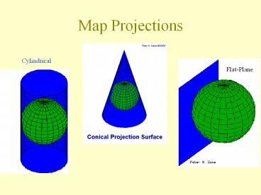
Map Projections
Cylindrical
Flat-Plane
2
Which one is the most accurate?
3
Type of Maps
4
Types of Maps
5
Types of Maps
6
Types of Maps
7
Types of Maps
8
Types of Maps
9
4 Map Properties
- Size
- Shape
- Distance
- Direction
10
Area (Size) -When a map portrays areas over the
entire map so that all mapped areas have the
same proportional relationship to the areas on
the Earth that they represent, the map is an
equal-area map. Conformality (Shape) - When the
scale of a map at any point on the map is the
same in any direction, the projection is
conformal. Meridians (lines of
longitude) and parallels (lines of latitude)
intersect at right angles. Shape is preserved
locally on conformal maps. Distance -
A map is equidistant when it portrays distances
from the center of the projection to any other
place on the map. Direction - A map preserves
direction when azimuths (angles from a point on
a line to another point) are portrayed correctly
in all directions.
11
The Peters Projection World Map is one of the
most stimulating, and controversial, images of
the world. When this map was first introduced by
historian and cartographer Dr. Arno Peters at a
Press Conference in Germany in 1974 it generated
a firestorm of debate. The first English-version
of the map was published in 1983.
12
Important characteristics of the Peters Map The
Peters Map is an equal area map. This new map
shows all areas - whether countries, continents
or oceans - according to their actual size.
Accurate comparisons become possible.The Peters
Map is an equal axis map. All North-South lines
run vertical on this map. Thus, geographic
points can be seen in their precise directional
relationship. The Peters Map shows equal
positions.
13
The earth is round. The challenge of any world
map is to represent a round earth on a flat
surface. There are literally thousands of map
projections. Each has certain strengths and
corresponding weaknesses. The Peters Projection
is an area accurate map.
14
The Peters Map and The Mercator Map
Which is bigger, Greenland or China? With the
traditional Mercator map (circa 1569, and still
in use in many schoolrooms and boardrooms today),
Greenland and China look the same size.
15
Greenland and China
Greenland is 0.8 million square miles. China is
3.7 million square miles.
16
Africa and the Former Soviet Union
The former Soviet Union is 8.7 million square
miles. Africa is 11.6 million square miles.
17
North and South
The North is 18.9 million square miles.The South
is 38.6 million square miles
18
The Mercator Map
19
The Mercator is a "conformal" map projection.
This means that it shows shapes pretty much the
way they appear on the globe. Today the
Mercator projection still remains useful for
navigational purposes and is referred to by
seafarers and airline pilots.
Typically, the cropping technique results in a
map showing the equator about 60 of the way down
the map, diminishing the size and importance of
the developing countries.
20
http//www.petersmap.com/page3.htmlhttp//www.co
lorado.edu/geography/gcraft/notes/mapproj/mapproj.
html
Credits
Recommended
CrystalGraphics Presentations


