
Plate Tectonics Can Explain: - PowerPoint PPT Presentation
Title:
Plate Tectonics Can Explain:
Description:
Plate Tectonics Can Explain: – PowerPoint PPT presentation
Number of Views:159
Avg rating:3.0/5.0
Title: Plate Tectonics Can Explain:
1
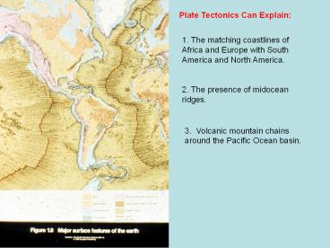
Plate Tectonics Can Explain
1. The matching coastlines of Africa and Europe
with South America and North America.
2. The presence of midocean ridges.
3. Volcanic mountain chains around the Pacific
Ocean basin.
2
Plate tectonics can explain matching coastlines
of South America and Africa, as well as matching
geology for older rock units on the two
continents.
3
Paleontological evidence supports plate tectonics
and plate motions.
4
(No Transcript)
5
(No Transcript)
6
Geothermal activity (shown as light color) most
often occurs near tectonic plate boundaries and
is less common in the interior of continents.
There are some locations around the world where
geothermal activity occurs in the interior of
continents, but these occurrences can be
explained in tectonic context.
7
To understand plate tectonics one must understand
the dynamics between the solid, rigid lithosphere
that is floating on a partially molten
asthenospherse. The lithosphere is composed of
continental and ocean crust and the uppermost
solid mantle. The asthenosphere is composed of
the upper mantle and is at or near the melting
temperature for upper mantle rock.
8
(No Transcript)
9
(No Transcript)
10
(No Transcript)
11
(No Transcript)
12
(No Transcript)
13
Inclination of the earths magnetic field varies
over latitude. It is parallel to the surface
over the equator and vertical over the magnetic
poles.
14
(No Transcript)
15
(No Transcript)
16
(No Transcript)
17
(No Transcript)
18
Ocean-Ocean lithosphere convergence
(subduction). Examples Japan and Phillipines
Ocean-Continent lithosphere convergence
(subduction). Examples Andes Mountains and
Cascade Mountains.
Continent-Continent lithosphere collision (no
subduction). Examples Himalaya Mountains and
European Alps.
19
(No Transcript)
20
Columbia Plateau
Cascades
Puget Lowland
Olympic or Coastal Mts.
Structure of a subduction zone. Note that the
geographic features relevant to the Cascadia
subduction zone are noted in red.
21
Ocean-Ocean convergence. Formation of an island
are (Japan).
22
(No Transcript)
23
Andesite is a volcanic rock formed at subduction
zones. Note the two sizes of crystals related to
two-staged cooling.
24
Ocean-Continental Convergence and formation of a
continental volcanic arc.
25
Mt. Rainier, Washington. Andesitic volcano.
26
Continental collisions are preceded by
ocean-continental convergence. As the
continental lithosphere arrives at the subduction
zone, it cannot be subducted because of its low
density. The collision cause upwarping and
deformation of the ocean floor and ocean
lithosphere. Even segments of the upper mantle
can be squeezed to the surface along the suture
zone (where the two continents are stitched
together).
27
The Indian tectonic plate collided with the
Eurasian plate and caused the uplift of the
Himalaya Mountains.
28
(No Transcript)
29
Uplift of the Himalaya Mountains was the result
of collisional tectonics between the Indian and
Eurasian Plates.
30
European Alps have formed from the collision of
the African Plate with the Eurasian Plate. The
Mediterranean Sea will disappear over time.
31
(No Transcript)
32
Formation of Appalachian Mountains resulted from
the collision of the African and European Plates
with North American Plate prior to 300 million
years ago.
33
Ural Mountains
Formation of the Ural Mountains related to
collision tectonics prior to 300 Ma ago.
34
(No Transcript)
35
(No Transcript)
36
Translational motion of the San Andreas Fault can
be seen by offset of streams that cross the fault
zone.
37
(No Transcript)
38
(No Transcript)
39
(No Transcript)
40
(No Transcript)
41
Future plate motions are predictable based on
current plate motions.
42
Inclination of the earths magnetic field varies
over latitude. It is parallel to the surface
over the equator and vertical over the magnetic
poles.
43
Movement of tectonic plates (including relative
movement of continents can explain the apparent
wandering of the paleomagnetic pole over geologic
time. Without a context of plate motions,
paleomagnetic evidence preserved in the rock
record would require unique magnetic poles for
different aged rock and locations.
Recommended
CrystalGraphics Presentations


