
DEVELOPMENT OF LANDSCAPES - PowerPoint PPT Presentation
1 / 20
Title:
DEVELOPMENT OF LANDSCAPES
Description:
Trellis or Rectangular. Radial or Annular. Five main patterns of drainage ... Trellis drainage is characteristic of areas with alternating parallel valleys and ridges. ... – PowerPoint PPT presentation
Number of Views:789
Avg rating:3.0/5.0
Title: DEVELOPMENT OF LANDSCAPES
1
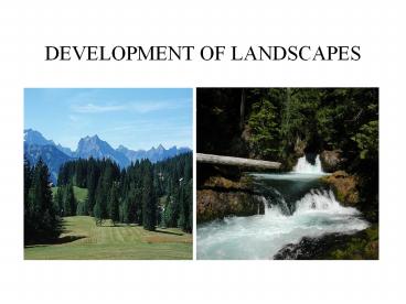
DEVELOPMENT OF LANDSCAPES
2
What is a Landscape?
- Landscapes are the general shape of the land
- Relief is the change in elevation from highest
point to lowest point that characterizes the
different landscapes. - Types of landscapes
- Mountains largest relief
- Plateaus medium relief
- Plains little to no relief (flat)
3
MOUNTAINS
- Mountains
- Greatest relief biggest change in elevation
(from high to low point) - Usually composed of metamorphic rock which is
very resistant to weathering - Physical weathering freeze-thaw in highest
elevations - Formed by tectonic uplift - so there are many
faults and folds
- Adirondack Mountains
4
PLATEAUS
- Allegheny Plateau
- Plateau has some elevation but are not as
rugged as mountains - Result from uplift of land features due to
tectonic activity - Generally composed of layers of sedimentary rock
- Usually less resistant to weathering because
sedimentary rock is generally weak - Rivers will carve out V shaped valleys
5
PLAINS
- Plains the lowest and least relief
- Underlying bedrock may be sedimentary
- Generally very flat, little slope (gradient),
wide flood plains and meandering streams
- Erie-Ontario Lowland
6
FACTORS THAT AFFECT LANDSCAPES
- GEOLOGIC FACTORS
- Composition of the underlying rock will affect
how it is weathered - Metamorphic rock and igneous rock generally very
resistant to weathering - Sedimentary rock less resistant to weathering and
generally affected by water
7
Drainage Patterns
- Streams will develop patterns based on the
geologic factors of the landscape - The main patterns are
- Dendritic
- Trellis or Rectangular
- Radial or Annular
8
Five main patterns of drainage
- The pattern of drainage in a basin is largely
determined by the underlying geology. - Streams typically follow the path of least
resistance, forming valleys where rock is most
readily eroded or following the steepest slope
gradient. - Dendritic drainage is characteristic of areas
where the geology is relatively uniform, for
example where rock layers are horizontal. Streams
intersect with a characteristic V-pattern. The
tip of the V points downstream. - Trellis drainage is characteristic of areas with
alternating parallel valleys and ridges. The
streams will intersect at right angles along
zones of weakness n the bedrock. - Rectangular patterns distinguish regions where
the bedrock exhibits well developed joints or
fractures. The streams flow along the fractures
as lines of weakness. - Radial drainage patterns are typically found on
the slopes of volcanoes, where streams flow
downslope. - Annular drainage results from a variety of
bedrock in a dome shape that has had some
faulting.
9
FACTORS THAT AFFECT LANDSCAPES
- CLIMATE FACTORS
- Humid (moist), warm climate will favor chemical
weathering and favors rolling, rounded landscapes - Arid (dry) climates will create very steep slopes
and angular formations
10
Climate Zones
- Climate is defined by the average conditions of
temperature (amount of insolation)and
precipitation (amount of moisture) - Climate factors influence landscape development
- Theses factors are
- latitude, altitude, nearness to large bodies of
water, ocean currents and wind belts, and
presence of mountains. - The earth is divided into climate zones due to
these factors and therefore contribute to the
landscape development in each zone
11
World Climate Zones
12
North America Climate Regions
13
LANDSCAPES OF NEW YORK
- New York State has unique landscape
characteristics - It is a combination of mountains, plateaus, and
plains - The geology of the land and the past tectonic
activity have all contributed to the development
of the landscape - The climate is less of a factor because it is
relatively uniform - Being seasonal which allows for the freeze thaw
of physical weathering in winter and the effects
of chemical weathering in the hot, humid summers. - The ESRT pp. 2 and 3 provides very specific
information about the NYS landscapes
14
ADIRONDACK MOUNTAINS
- In Northeast NY
- Mt. Marcy the highest peak in NY
- Composed of metamorphic rock
- About 1 billion years old
15
ALLEGHENY PLATEAU AND THE CATSKILLS
- Allegheny Plateau is an extension of the an
extension of the Appalachian Plateau formed by
collision of North America with Africa forming
Pangea (300 million years ago) - Many glacial features such as the Finger Lakes
- Catskills are not true mountains
- Layers of sedimentary rock from the erosion of
the Acadian Mountains about 400 million years ago.
16
PLAINS (LOWLANDS)
- Borders of Lakes Erie and Ontario are rich with
glacial till and drumlins. The large bodies of
water moderate the climate and allow for a longer
growing season
- Long Island (Atlantic Coastal Plain) is the
moraine from the last glacier about 10,000 years
ago - Northern border is low lying hills and the
southern border are the beaches formed from
glacial water as outwash plains.
17
TUG HILL PLATEAU
- Rather remote region
- Low population
- Highest snowfall in NYS
18
HUDSON VALLEY
- Hudson River the main waterway
- Palisades tall columns of igneous rock formed
about 200 million years ago during the breakup of
Pangea - Other features Taconic Mountains, Hudson
Highlands, Manhattan Prong complex geology
19
Drainage Patterns in NY
- The variety of landscapes in NYS also allowed for
development of different drainage patterns.
20
Watersheds in NY
- A watershed is a gathering place. It is a place
where hills and plains and peoples lives are
connected by falling rain, melting snow, and
flowing water. - A watershed is any area of land that drains to a
common point.
Recommended
CrystalGraphics Presentations


