
Case Study: Audrain County ELT 1: Loess Summits and Flats - PowerPoint PPT Presentation
1 / 18
Title:
Case Study: Audrain County ELT 1: Loess Summits and Flats
Description:
Goss-Gasconade-RO, 5-35% ELTs: 10: Protected Limestone Backslopes ... Mostly Gasconade-like, with mod. deep components (Bardley, Clinkenbeard) ... – PowerPoint PPT presentation
Number of Views:40
Avg rating:3.0/5.0
Title: Case Study: Audrain County ELT 1: Loess Summits and Flats
1
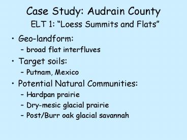
Case Study Audrain County ELT 1 Loess Summits
and Flats
- Geo-landform
- broad flat interfluves
- Target soils
- Putnam, Mexico
- Potential Natural Communities
- Hardpan prairie
- Dry-mesic glacial prairie
- Post/Burr oak glacial savannah
2
Comparison ResultsSoils in ELT 1
- 41 Mexico sil, 1-3
- 25 Mexico sicl, 1-3 eroded
- 14 Leonard sicl, 2-4 eroded
- 9 Putnam sil
- 9 Armstrong l, 4-9, eroded
- Green target soil
- Blue adjacent soil
- Red off-target (error)
3
Comparison ResultsELTs in target soils for ELT 1
- Putnam
- 94 ELT1
- 5 ELT 4 (Gentle loess backslopes)
- Mexico (uneroded)
- 88 ELT1
- 6 ELT4
- 5 ELT2 (Loess ridges)
- Mexico (eroded)
- 67 ELT1
- 15 ELT2
- 14 ELT4
4
Putnam soils and ELT 1
ELT 1
ELT Error
34 Putnam
Soil Error
5
Mexico (uneroded) and ELT 1
Minor discrepancies not worth worrying about
Mexico
ELT 1
6
Mexico (eroded) and ELT 1
ELT 1
Leonard-like inclusions?
Mex. eroded
ELT 4
Gorin-like inclusions?
7
Conclusions ELT 1
- A few delineations of Putnam can be trimmed back,
via ELT 1. - ELT 1 model can be improved by including all
areas of (revised) Putnam. - The Leonard / Mexico Eroded interface can be
reviewed via the ELT 1 model. - Most discrepancies are minor fuzzy edges, and
not worth worrying about.
8
ELT 7 Gentle Till Backslopes
- Target soils Armstrong, Keswick, 5-9
- Soils in ELT 7
- 59 Armstrong 4-9
- 25 Keswick 5-9
- ELTs in Armstrong 4-9
- 53 ELT 7
- 17 ELT1 (summits)
- 10 ELT2 (ridges)
- 7 footslopes/terraces
- 6 floodplains
- 5 upland waterways
9
Armstrong 4-9 and ELT 7
Generally good agreement Minor boundary
discrepancies
10
Conclusions ELT 7 and Armstrong
- Most discrepancies are due to fuzzy boundaries.
- Narrow upland drains are inclusions in Armstrong.
- Small Gorin-like ridges are included in
Armstrong. - Minor line adjustments are possible in some areas.
11
ELT 4 Gentle Loess Backslopes
- Target soil Leonard, 2-4
- Head slopes below Mexico interfluves
- Soils in ELT 4
- 60 Leonard 2-4
- 23 Mexico eroded, 1-3
- 13 Mexico 1-3
- ELTs in Leonard, 2-4
- 43 ELT 4
- 43 ELT 1 (summits)
12
Leonard 2-4 and ELT 4
Leonard
Leonard here?
ELT 4
ELT error (seen previously)
13
Callaway CountyWheres the Leonard?
- Leonard soils not mapped in Callaway county.
- Mexico extends down into head slope positions
where Leonard is usually mapped. - Can ELT4 be used to estimate Leonard map unit
locations?
14
ELT4 N. Callaway co.
ELT4 Leonard soil? Mapped Mexico eroded
15
Callaway 18FGoss-Gasconade-RO, 5-35
- ELTs
- 10 Protected Limestone Backslopes
- 11 Exposed Limestone Backslopes
- 12 Protected Shallow to Limestone
- 13 Exposed Shallow to Limestone
16
18F preliminary results of field investigations
- ELTs 12 13 (glades)
- Photointerpret and map at 112,000
- Mostly Gasconade-like, with mod. deep components
(Bardley, Clinkenbeard) - Concentrated on exposed aspects
- ELTs 9 10 (forests)
- Different map units, based on soil properties, on
exposed vs protected - Exposed less loess, more surface frags,
shallower - Possible geologic differences
- Upper watershed positions Mississippian (?)
cherty surfaces Bardley-like soils - Lower watershed positions Ordovician (?) less
chert Gatewood-like or Caneyville-like soils - Analysis of soil and vegetation data will
probably result in (potential) new soil map units
and ELTs.
17
Conclusions to date
- ELTs and soil map units are not exactly
coincident - Soil map units may be nested within an ELT
- Putnam, Mexico (uneroded) nest within ELT 1
(Loess Summits and Flats) - Gorin, Hatton nest within ELT 2 (Loess/Till
Ridges) - Some of these may be used to define ELT phases
- ELTs may nest within soil map units
- Exposed and Protected aspect ELTs within soil
survey steep backslope units. - Consider different soil survey map units.
- Fuzzy Boundaries account for much of the
difference between soil units and ELT units.
18
Conclusions, cont.
- Both soils and ELT model have errors.
- ELT errors due to inconsistency among landforms
within modeling area, problems with DEM (contour
line bias), etc. - Soils inconsistencies for all the reasons that
we already know about. - Developing ELTs and evaluating soil surveys
together can greatly improve both products. - The use of Fuzzy Logic can create a more
realistic model for both soils and ELTs. - We will still need hard lines.
- Soil ELT correlation provides an excellent
template for future project work. - More on this tomorrow!