
Hazus PowerPoint PPT Presentations
All Time
Recommended

Title: Recommending a Strategy Last modified by: FEMA Created Date: 6/2/1995 10:11:14 PM Document presentation format: Custom Other titles: Times New Roman Arial ...
| PowerPoint PPT presentation | free to download

9. FEMA's Commitment to HAZUS 1993 - 2005 $17.5 Million through 2000 $40.0 Million though 2005 ... Greater San Francisco Bay Area. Vision ...
| PowerPoint PPT presentation | free to download

key com.apple.print.ticket.creator /key string com.apple.printingmanager /string ... xA;Add Layer Mask Master Opacity Change Eraser Eraser ...
| PowerPoint PPT presentation | free to view

hazus most software in hazard analysis
| PowerPoint PPT presentation | free to view

HAZUS-MH: FEMA'S SOFTWARE PROGRAM FOR ESTIMATING POTENTIAL LOSSES FROM DISASTERS ... HAZUS-MH is free from FEMA. Current HAZUS-MH version (MR3) runs on ArcGIS 9.2 ...
| PowerPoint PPT presentation | free to download

It is a planning tool, NOT an engineering tool. Engineering-level data (i.e. Hydrology & Hydraulic studies for Flood modeling) ...
| PowerPoint PPT presentation | free to view

Application of spatial information technologies, including GIS, to addressing a ... Education program providing introductory thru advanced courses ... DMA 2000 ...
| PowerPoint PPT presentation | free to download

... Gas, Electric Power, Communication Facilities High Potential Loss Facilities Dams and Levees, Nuclear Facilities, Hazardous Material Sites, ...
| PowerPoint PPT presentation | free to download

... with Bay Area HAZUS users group and Working Group on Bay Area earthquake probabilities. ... soil type & the proportion of each soil type within the area. ...
| PowerPoint PPT presentation | free to download

HAZUS MH Earthquake, Wind, Flood
| PowerPoint PPT presentation | free to view

Initiated Dec 94 - adopted Dec' 97. Objectives: Prevent or reduce loss of life and damage ... Range: 11.0 to -4.6. Mallard and McAlpine Data. Intuitive. ...
| PowerPoint PPT presentation | free to view

Wind Hazard Modeling and the HAZUS Wind Model Major Stakeholders Local, state and federal government agencies Humanitarian organizations Insurance industry Businesses ...
| PowerPoint PPT presentation | free to view

Improving USGS Input into HAZUS
| PowerPoint PPT presentation | free to download

An Overview of HAZUS MultiHazard: FEMAs GISbased, Multihazard Risk Assessment Program for Analyzing
| PowerPoint PPT presentation | free to view

Analyzing impacts of new mapping (Mecklenberg, NC) ... Potential sources: DFIRM, FEMA Q3. Flood Information Tool. Floodplain Boundary ...
| PowerPoint PPT presentation | free to view

Water, Oil, Gas, Power, & Comm. HAZUS Installed on Hard Drive. HAZUS Engine. Template Files ... Better done at source level (i.e., HAZUS CD) Less files to worry about ...
| PowerPoint PPT presentation | free to view

Access to the models (CATS, HAZUS) on the server or data download. Update Base data for the models ... Scott Parsons (MOU Facilitation) Local to HS Data Model ...
| PowerPoint PPT presentation | free to view

Celebrate Success. Summit. Risk Assessment Tools. HAZUS: multi-hazard loss estimation model ... National Earthquake Hazard Reduction Program (NEHRP) National ...
| PowerPoint PPT presentation | free to download

REGION VIII EARTHQUAKE PROGRAM. Disaster ... inventories and hazard maps) FEDERAL EMERGENCY MANAGEMENT ... HAZUS GIS Inventories and Hazard Maps ...
| PowerPoint PPT presentation | free to view

National Hurricane Conference Training Session
| PowerPoint PPT presentation | free to view

Title: Flood Loss Estimation Author: Eric Tate Last modified by: Jenny Dubeansky Created Date: 6/10/2003 9:29:00 PM Document presentation format: On-screen Show
| PowerPoint PPT presentation | free to download

Title: JASON MASTERS Author: TEAM2 Last modified by: Mark Benthien Created Date: 7/29/2002 3:27:49 PM Document presentation format: On-screen Show Company
| PowerPoint PPT presentation | free to view

Serve maps visually through Web. Collaborative effort. Silver Jackets: A Natural Hazard ... data (XML) through the NWS Advanced Hydrologic Prediction Service ...
| PowerPoint PPT presentation | free to view

Used for emergency preparedness, response, and recovery planning. Works with GIS software to display graphical maps of earthquake hazards and potential damage ...
| PowerPoint PPT presentation | free to view

Modeling Flood Hazards
| PowerPoint PPT presentation | free to view

Mississippi. 82 Counties. Missouri. 115 Counties. Tennessee. 95 Counties ... Assessment, Mitigation, Response and Recovery. Upcoming Activities. Planned Work ...
| PowerPoint PPT presentation | free to download

Texas Geographic Society Presentation 1 of 2 Roddy Seekins The Texas Hazard Mitigation Package (THMP): An Internet-based GIS Data Distribution Tool
| PowerPoint PPT presentation | free to download

Title: Vulnerability to a natural hazard can be defined as to the extent to which people will experience harm and property will be damaged from that hazard.
| PowerPoint PPT presentation | free to view

Major focus on utilizing best available data to make best maps possible ... Live entertainment, good food and refreshing beverages. PaMAGIC Board Election ...
| PowerPoint PPT presentation | free to view

Real-Time Tsunami Origins. Other Stuff National Event Display System? Links to Other Data ... Tsunami Mapping and Mitigation Program ...
| PowerPoint PPT presentation | free to view

... computer aided design performance based codes and standards active and passive energy dissipation devices (e.g., base isolation) ... databases seismic ...
| PowerPoint PPT presentation | free to download

Title: Sources of Free Data: Author: Irvin A Goldblatt Last modified by: Jenny Dubeansky Created Date: 2/21/2000 3:25:24 PM Document presentation format
| PowerPoint PPT presentation | free to download

MEMPHIS Mapping for Emergency Management, Parallel Hazard Information System ... Automated Critical Asset Management System. User names/password required ...
| PowerPoint PPT presentation | free to download

To increase earthquake awareness and knowledge so that people take actions that ... Despite these facts, no southern California GIS laboratory, training facility ...
| PowerPoint PPT presentation | free to download

Preparing Effective Risk Assessments
| PowerPoint PPT presentation | free to view

... Precast/Tilt-up Concrete Shear Wall Buildings One or more stories Precast concrete perimeter wall panels cast on site and tilted into place Steel plates ...
| PowerPoint PPT presentation | free to view

Hurricanes plague the east coast, while earthquakes affect the west. ... ASCE 7 wind speed design map (mph) Loads converted to a generalized demand parameter ...
| PowerPoint PPT presentation | free to download

Module 6 ICT in Disaster Management Teknethix Inc. George M Richards gmrichards@rogers.com (416) 282-8964 September 2006
| PowerPoint PPT presentation | free to download

RI: several thousand years. Probable M: 6.0 - 7.0. Distance: ~14 miles. Newport-Inglewood. Fault Zone. Last known rupture: Mar. 10, 1933. RI: unknown ...
| PowerPoint PPT presentation | free to view

NASA Goddard Space Flight Center. 2. NASA Applications Program. Data ... Public Health: RSVP. Homeland Security: OHS Situation Center. Disaster Preparedness: ...
| PowerPoint PPT presentation | free to download
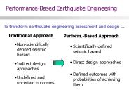
Performance-Based Earthquake Engineering To transform earthquake engineering assessment and design ... Perform.-Based Approach Scientifically-defined seismic hazard
| PowerPoint PPT presentation | free to download

Emergency Management
| PowerPoint PPT presentation | free to view

Cristian ARION, UTCB. Mihail IANCOVICI, UTCB. CONTENT. Seismic fragility analysis ... estimation of earthquake damage to buildings given knowledge of the model ...
| PowerPoint PPT presentation | free to view

Risk Assessment Public Safety Geoscience Program Earth Sciences Sector Nicky Hastings, Bert Struik, Murray Journeay, Malaika Ulmi Centre for
| PowerPoint PPT presentation | free to view

CISN Outreach: Transferring RealTime Information Products to Users
| PowerPoint PPT presentation | free to download

How do estimates change for different building types? ... JA Mulrennan College of Entomology. Panama City, FL. FEMA.gov. Florida A&M University ...
| PowerPoint PPT presentation | free to view

David Wald, Vincent Quitoriano, Bruce Worden
| PowerPoint PPT presentation | free to view

3) Hazard Map Data Calculator. 1) Hazard Curve Calculator. 2) Scenario ShakeMap ... Fault-offset probability computed at the Alaska Oil Pipeline (for Alyeska) ...
| PowerPoint PPT presentation | free to view

... Command Tool for Drinking Water Protection ... Drinking water sources are vulnerable to ... important source of public drinking water. Specifications ...
| PowerPoint PPT presentation | free to view

Catastrophic Preparedness Catastrophic events exceed our ability to accurately anticipate hazard generated humanitarian needs, to develop the capacity and ...
| PowerPoint PPT presentation | free to download

James D. Goltz Ph.D. Earthquake and Tsunami Program Manager California Emergency Management Agency CISN Steering and Advisory Committee Meeting Sacramento, October 13 ...
| PowerPoint PPT presentation | free to download

USGS website has 3 data points per location, by lat/long and by zip code. ... 4. Automatic lookup tables for 700 WA Zip Codes. Building Seismic Damage Functions ...
| PowerPoint PPT presentation | free to view

LESSONS LEARNED FROM PAST NOTABLE DISASTERS PERU PART 1: FLOODS Walter Hays, Global Alliance for Disaster Reduction, Vienna, Virginia, USA HEALTH IMPACTS The flooding ...
| PowerPoint PPT presentation | free to download

Southern CA Edison The Southern California Seismic Network and Its Products Sept 20, 2005 Hugo Rico,
| PowerPoint PPT presentation | free to download

I-880 Viaduct. Bay Area Highway Network. 17. Performance Assessment Components. Decision Variable ... I-880 Viaduct. Bay Area Highway Network. 24. Evolution of ...
| PowerPoint PPT presentation | free to view

FEMA s Mitigation Directorate and Hurricane Emergency Management The Mitigation Directorate supports Hurricane risk assessment and emergency management through ...
| PowerPoint PPT presentation | free to download