
Baseflow PowerPoint PPT Presentations
All Time
Recommended

Runoff/CN overestimated using land cover and soil group. Large variation from month to month ... CN table used might overestimate ...
| PowerPoint PPT presentation | free to download

Soil and Water Assessment Tool (SWAT model) Cattaraugus Creek Watershed with ... 10 sampling events per site- 5 baseflow, 5 storm event. One 2 liter sample ...
| PowerPoint PPT presentation | free to view

B. C. E. Baseflow. Direct Runoff. Abstraction (Losses) Estimation. Phi Index Method ... tlag - basin lag, time between center of rainfall excess and UH peak ...
| PowerPoint PPT presentation | free to view

Initial Implementation of VIC within CCSM ... non-linear baseflow generation. critical elements relevant to high latitude implementations: a snow model, a ...
| PowerPoint PPT presentation | free to download

A=watershed area; C=conversion constant(2.08 in SI) ... Accounting loss model (last time) Outflow linearly related to average storage of each time interval ...
| PowerPoint PPT presentation | free to download

NARR-Noah average percent of precipitation that becomes recharge ... Propose modifications to Noah LSM that will improve vadose-zone moisture transport ...
| PowerPoint PPT presentation | free to download

Highlands (PreCambrian and Limestone) Sourlands and Cushetunk Mountain (diabase) ... Examples for the Highlands Precambrian Rock aquifers: 7 day 10 year low ...
| PowerPoint PPT presentation | free to view
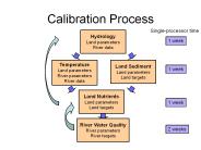
The importance' ratio is 2:1, so Land Segment A uses 2/3 of the station1 ... Labile. Organic N. Adsorbed. Ammonia. Solution. Refractory. Organic N. AGCHEM simulation ...
| PowerPoint PPT presentation | free to download

Sustainable Groundwater Management Applications for Central Gulf Coast Aquifer Venkatesh Uddameri Texas A&M University-Kingsville; MSC 213 Kingsville, TX 78363
| PowerPoint PPT presentation | free to download

Strategy for Interactive Calibration of the Sacramento Model Using NWSRFS Interactive Calibration Program (ICP)
| PowerPoint PPT presentation | free to view

Soil and groundwater infiltration rates/travel times, overland travel time ... Coniferous Forests. Storage Capacity (mm) Storage Capacity (in) Ground Cover ...
| PowerPoint PPT presentation | free to view
HYDROLOGIC MOELING SYSTEM HEC-HMS Hydrologic Modeling Event or Continuous Lumped or Distributed A Distributed Model is one in which the spatial (geographic ...
| PowerPoint PPT presentation | free to download

Runoff and Streamflow Runoff/streamflow major focus in hydrology due to relation to: Floods: high runoff events -- flooding (need flood protection)
| PowerPoint PPT presentation | free to view

Special problems with groundwater:
| PowerPoint PPT presentation | free to view
Developing ICPRB s Potomac Watershed Model using Soil & Water Assessment Tool Kaye Brubaker Univ. of Maryland, College Park Cherie Schultz, ICPRB
| PowerPoint PPT presentation | free to download

Arc Hydro geodatabase developed for full Salado Creek watershed. TAMU and UT developed Arc Hydro ... Evaluating flash flood forecasting for smaller watersheds ...
| PowerPoint PPT presentation | free to download

Direct deposition and dairy shed waste discharges to streams ... Shedding rate at high end (1010/cow/day) required to get concentrations in stream high enough ...
| PowerPoint PPT presentation | free to view

Graph of excess rainfall versus time is called excess rainfall hyetograph ... Used to compute excess rainfall hyetograph when observed rainfall and streamflow ...
| PowerPoint PPT presentation | free to download
Texas Water Development Board model to evaluate needs for instream and ... Study Area-Buffalo Bayou Tidal Watershed. Calibrating the Model ...
| PowerPoint PPT presentation | free to download

Geology controls flow and availability of groundwater. Hydrogeology Defined ... Landforms: Valley development and karst topography ...
| PowerPoint PPT presentation | free to download
Byram Township NJDEP Matching Grant Groundwater Assessment John Robinson, PG, CPG Hydrogeologist GeoEnvironmental Research Aquifer yield is evaluated by conducting an ...
| PowerPoint PPT presentation | free to download

Pervious Area Runoff. Identify the hydrologic soil groups. A High infiltration rates ( .3 in/hr) ... Pervious Area. Runoff = 4.01 in/yr. Estimating Runoff ...
| PowerPoint PPT presentation | free to view

Hydrologic Research at the Baltimore Ecosystem Study
| PowerPoint PPT presentation | free to download

Maps in the Piedmont and Coastal Plain Provinces of North Carolina. ... USGS Water Resources Investigation Report 96-4220 Ground-Water Recharge to the ...
| PowerPoint PPT presentation | free to view

Primarily Urban Runoff Model (wet weather flow) Existing studies available. Existing parameterization information available. Multiple Buildup/Washoff Functions ...
| PowerPoint PPT presentation | free to view

The Storm Hydrograph Specification Focus: Factors affecting discharge: the storm hydrograph. Bar and line graphs Learning Outcomes: recognise the regimes of different ...
| PowerPoint PPT presentation | free to download

Modelling the Entire Great Lakes and the Ottawa River Watershed
| PowerPoint PPT presentation | free to download

Percent of Precipitation in Outcrop. Computer Modeling. Depletion from Storage ... Percent of Precipitation in Outcrop. Computer Modeling. Depletion from ...
| PowerPoint PPT presentation | free to view

use to predict entire stream flow hydrograph for any given storm. UH derivation. direct method. indirect methods (synthetic UHs) UH Derivation: Direct Method Example ...
| PowerPoint PPT presentation | free to view

http://www.cpc.ncep.noaa.gov/soilmst/paper.html. Soil Moisture Budget (2) ... SAC-SMA Model Parameters. http://www.crh.noaa.gov/ncrfc/doc/calibration/flowing.html ...
| PowerPoint PPT presentation | free to download

SWOT Integration with In-Situ Measurement Networks and the Combined Utility for Water Cycle Modeling Jay Famiglietti Department of Earth System Science
| PowerPoint PPT presentation | free to download

Photo-Realistic Visualizations. RIVERSIDE, PHOTO-RENDERED POINT CLOUD. 3 ... airborne and terrestrial laser scanning. Floods of data into oceans of information ...
| PowerPoint PPT presentation | free to view

Civil Engineering. 1 / 20. Validation of Hydrological Models ... 1 Civil Engineering and 2Earth Sciences, University of Waterloo, Waterloo, ON, N2L 3G1, Canada ...
| PowerPoint PPT presentation | free to view

A Water Quality Loading Model for Tillamook Bay. Patrice A. Melancon. Thanks to: ... Bay Depth Below MSL. GIS Coverage Representation ...
| PowerPoint PPT presentation | free to download

Forest/Ag (two) Ag/Residential (two) Forest/Residential (three) Limitations ... Seems to provide discrimination among the subwatershed types encountered in the ...
| PowerPoint PPT presentation | free to download

Projected Changes in Indus River Flows due to Melting of HKH Glaciers ... Projection of flows in the river of the Indus Basin in the light of CC scenarios ...
| PowerPoint PPT presentation | free to download

Water and Climate Modeling
| PowerPoint PPT presentation | free to view

Head measured in an observation well is known as a target. ... Residual error = observed - simulated ... a set of parameters that matches the observed head values. ...
| PowerPoint PPT presentation | free to download

Soil changes: hydrophobicity, surface sealing. Dead vegetation. Altered local weather patterns ... 'We are seeking - we always have been and we always will ...
| PowerPoint PPT presentation | free to view

Christakis Roumbas, P'E, Senior Associate, Hazen and Sawyer P'C'
| PowerPoint PPT presentation | free to view

Accounting for Sediment and Geomorphology in Flood Risk Management Colin Thorne Chair of Physical Geography, Nottingham University and Faculty Affiliate, Portland ...
| PowerPoint PPT presentation | free to download

City of Austin Water Quality Master Planning GIS Model
| PowerPoint PPT presentation | free to view

RUNOFF Hydrographs and the SCS Curve Number Method AGSM 335 Homework 4 RAINFALL HYETOGRAPH EFFECTIVE RAINFALL HYETOGRAPH CREATING AN EFFECTIVE RAINFALL HYETOGRAPH ...
| PowerPoint PPT presentation | free to view

Residential Commercial/Industrial ... Minnesota, Florida, Texas, California Street Sweeping ... 14.29 20.00 8.57 17.14 14.29 25.71 water quality. Chart1. storm ...
| PowerPoint PPT presentation | free to download

2. Overland flow into streams: quickflow ... Step 2 Lack of Infiltration = overland flow. Two conditions lead to overland flow: ...
| PowerPoint PPT presentation | free to download

Title: Diapositive 1 Author: PUBLICIS Last modified by: boonslang Created Date: 5/19/2006 1:16:10 PM Document presentation format: Affichage l' cran
| PowerPoint PPT presentation | free to download
Flood Frequency A. Flood Frequency Analysis Slide 93 Slide 94 Slide 95 Slide 96 Slide 97 V. Sediment Transport A. Shear Stress V. Sediment Transport A. ...
| PowerPoint PPT presentation | free to download

1 Civil Engineering and 2Earth Sciences, University of Waterloo, Waterloo, ON, ... Confluence of MacKenzie and Liard Rivers. Inter-relationship via spring melt ...
| PowerPoint PPT presentation | free to view

The project is an outgrowth of the Georgia Governor's Green Space Initiative and ... Under UV light, cells fluoresce blue-green in the presence of E. coli bacteria ...
| PowerPoint PPT presentation | free to download

a soil water accounting module that produces surface and sub-surface runoff for each sub-basin ... Basin Excess Rainfall Maps (BERM) Produced. Output ...
| PowerPoint PPT presentation | free to download

If teak was planted over entire catchments it could have a serious effect on streamflow. ... across many Catchments. Effect on any one catchment small. Effects ...
| PowerPoint PPT presentation | free to download

Wisler & Brater - 1949 - 'the hydrograph of surface runoff resulting from a ... by plotting the precipitation in hyetograph form and drawing a horizontal line ...
| PowerPoint PPT presentation | free to view

Time of Concentration. Rising Limb. Recession Limb (falling limb) Peak Flow ... Time of concentration. Duration of excess precip. Base flow. Methods of ...
| PowerPoint PPT presentation | free to view

Pesticides in urban settings. Use of a Pesticide ... Croton watershed. NYC water supply. 47 sites. small streams. range of urban. Methods- Water samples: ...
| PowerPoint PPT presentation | free to view

Applied moisture is distributed properly in various depths ... Pervious Area. E T. Impervious Area. Tension Water. UZTW Free Water. UZFW. Percolation. Zperc. ...
| PowerPoint PPT presentation | free to download

Russell Creek ... Jones and Grant analysis suggests a change in peak flow ... Storm Hydrograph - Russell Creek. Rising Limb. Falling or Recession. Limb ...
| PowerPoint PPT presentation | free to download